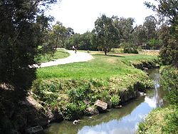
Gardiners Creek and Trail in Gardiners Reserve, Burwood
Length
Approx 17 km
Location
Melbourne, Victoria, Australia
Difficulty
Mostly easy
Hazards
Can be very crowded
Surface
Bitumen
Hills
Mostly flat
Water
Water fountains at several locations
Train(s)
Kooyong, East Malvern and Blackburn Stations
The Gardiners Creek Trail is a shared use path for cyclists and pedestrians, which follows Gardiners Creek through the eastern suburbs of Melbourne, Victoria, Australia.[1][2][3][4]
Bicycle Victoria is campaigning for a connection between Winton Road and Warrigal Road, to complete the gap in the trail at this point. It is proposed that the path would continue along the creek parallel to the Malvern Public Golf Course, spanning the gap from Winton Road to Warrigal Road.
^VicRoads - Bicycle Facilities Map Archived 19 February 2007 at the Wayback Machine
^Melbourne and Geelong's shared paths in Google Maps
^"Melbourne and Geelong's shared paths in Google Earth". Archived from the original on 12 October 2016. Retrieved 13 June 2007.
^Travel Smart Map for Boroondara Archived 15 September 2009 at the Wayback Machine
and 26 Related for: Gardiners Creek Trail information
The GardinersCreekTrail is a shared use path for cyclists and pedestrians, which follows GardinersCreek through the eastern suburbs of Melbourne, Victoria...
Stadium (Kooyong) The GardinersCreekTrail, a shared use cycling and pedestrian track, follows the general course of GardinersCreek from Box Hill's boundary...
overhead wiring to the GardinersCreekTrail in Malvern East through to Hughesdale Train Station in the south. Leaving the Yarra River Trail head south on the...
schema. Stonnington City Council introduced solar lighting on the GardinersCreekTrail in May 2007. However they did not make use of a color schema as...
The path is useful as it provides a shortcut between GardinersCreekTrail and Anniversary Trail. These two paths converge 2.5 km further to the south...
end of Wurundjeri Walk Trail starts at Boardman Close, near the clubhouse of the Box Hill golf club. See the GardinersCreekTrail for more detail. 200...
The Outer Circle Trail for cyclists and walkers continues along the Outer Circle alignment after Alamein as far as GardinersCreek and the Malvern Valley...
Scotchmans CreekTrail (1 km) and GardinersCreekTrail (2 km) can be reached by travelling west from Warrigal Road at Holmesglen railway station. Trail users...
with the Dandenong CreekTrail, as well as the EastLink Trail. Nearby in the north is the GardinersCreekTrail and the Anniversary Trail. It connects centrally...
The Diamond CreekTrail is a shared use path for cyclists and pedestrians, which follows Diamond Creek through the north eastern outer suburbs of Melbourne...
down towards Blackburn Lake sanctuary, which also leads to the GardinersCreekTrail In the Nunawading - Mitcham section, it connects with the Nunawading...
Scotchmans CreekTrail connects at the west end to the GardinersCreekTrail and the Outer Circle Trail and connects East Malvern Station to Centre Rd Trail. The...
The Ferny CreekTrail is a shared use path for cyclists and pedestrians, which follows Ferny and Corhanwarrabul Creeks through the suburbs of Knoxfield...
points along the trail, such as the Shawangunk Ridge to the west and the Plattekill Creek between New Paltz and Gardiner. The trail passes through dense...
-37.76839; 144.98405 The Merri CreekTrail is a shared use path for cyclists and pedestrians that follows the Merri Creek through the northern suburbs of...
The Taylors CreekTrail is a shared use path for cyclists and pedestrians, which follows Taylors Creek in the outer north-west suburb of Taylors Lakes...
The Moonee Ponds CreekTrail is a shared use path for cyclists and pedestrians, which follows the Moonee Ponds Creek through the northern suburbs of Melbourne...
The Tarralla CreekTrail is a shared use path for cyclists and pedestrians, which follows Tarralla Creek (previously known as the Croydon main drain)...
The Edgars CreekTrail is a shared use path for cyclists and pedestrians in the suburb of Thomastown, an inner northern suburb of Melbourne, Victoria...
The Darebin CreekTrail is a shared use path for cyclists and pedestrians which follows Darebin Creek in the inner and outer northern suburbs of Melbourne...
follows the Blind Creek from the Dandenong CreekTrail in Wantirna South to the Ringwood - Belgrave Rail Trail in Boronia. This trail is one of the major...
The Steele CreekTrail is a shared use path for cyclists and pedestrians, which follows Steele Creek in the Outer North Western suburbs of Keilor Park...
The Koonung CreekTrail, also known as the Koonung Trail, is a shared use path for cyclists and pedestrians, which follows Koonung Creek in the eastern...
The Skeleton CreekTrail is a shared use path for cyclists and pedestrians, which follows Skeleton Creek as it passes through the outer south western...
 Global Information