Bowron River, Willow River, Quesnel River, Thompson River, Coquihalla River, Chilliwack River, Sumas River, Salmon River (lower mainland)
• right
Morkill River, McGregor River, Salmon River (interior), Nechako River, West Road (Blackwater) River, Chilcotin River, Bridge River, Harrison River, Stave River, Pitt River, Coquitlam River
Protection status
Ramsar Wetland
Official name
Fraser River Delta
Designated
24 May 1982
Reference no.
243[8]
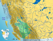
The Fraser River (/ˈfreɪzər/) is the longest river within British Columbia, Canada, rising at Fraser Pass near Blackrock Mountain in the Rocky Mountains and flowing for 1,375 kilometres (854 mi), into the Strait of Georgia just south of the City of Vancouver.[5][9] The river's annual discharge at its mouth is 112 cubic kilometres (27 cu mi) or 3,550 cubic metres per second (125,000 cu ft/s), and each year it discharges about 20 million tons of sediment into the ocean.[10]
^Salishan languages and Chinook Jargon. The Halkomelem form is Sto:lo, used as the name of the people of the Fraser Valley stretch of the river. "Staulo" is the anglicization used in the Kamloops Wawa lexicon of the Chinook Jargon
^Carrier language. Lhtako is also used to mean the Dakelh people of the Quesnel/North Cariboo area
^Indigenous name recorded by Alexander Mackenzie on expedition to find Columbia River’s headwaters; circa 18-?
^Tsilhqot'in name meaning Sturgeon (ʔElhdachogh) River (Yeqox)
^ ab"Fraser River Fact Sheet". Canadian Heritage Rivers System. Archived from the original on July 12, 2017. Retrieved December 2, 2016.
^Ambient Water Quality Assessment and Objectives for the Fraser River sub-basin from Kanaka Creek to the Mouth Archived March 4, 2016, at the Wayback Machine, BC Ministry of Environment
^Cite error: The named reference review was invoked but never defined (see the help page).
^"Fraser River Delta". Ramsar Sites Information Service. Retrieved April 25, 2018.
^"BC Geographical Names". Retrieved June 2, 2019.
^Cannings, Richard and Sidney. British Columbia: A Natural History. p.41. Greystone Books. Vancouver. 1996
The FraserRiver (/ˈfreɪzər/) is the longest river within British Columbia, Canada, rising at Fraser Pass near Blackrock Mountain in the Rocky Mountains...
State. It starts just west of Hope in a narrow valley encompassing the FraserRiver and ends at the Pacific Ocean stretching from the North Shore Mountains...
The Fraser Canyon Gold Rush, (also Fraser Gold Rush and FraserRiver Gold Rush) began in 1858 after gold was discovered on the Thompson River in British...
Vancouver, which was the largest port in Canada; the FraserRiver Port Authority; and the North Fraser Port Authority. The Vancouver Port Authority was responsible...
The Fraser Canyon is a major landform of the FraserRiver where it descends rapidly through narrow rock gorges in the Coast Mountains en route from the...
the language of the indigenous people along the lower reaches of the FraserRiver (one of British Columbia's many native Coast Salish languages). Suk-kegh...
by the Cascade Mountains, and is traversed from east to west by the FraserRiver. Due to its consistency of climate, flora and fauna, geology and land...
This is a list of bridges, tunnels, and other crossings of the FraserRiver in the Canadian province of British Columbia. It includes both functional crossings...
The following is a list of characters in River City, a Scottish soap opera that began broadcasting on BBC Scotland on 24 September 2002. "A look back...
Victoria Fraser Island, along the coast of Queensland FraserRiverFraser Plateau, a subplateau of the Interior Plateau, named for the riverFraser Basin...
: 21 Of the two catastrophic floods on the Lower FraserRiver since European settlement in the Fraser Valley, the flood of 1894 is considered to be the...
The Alex Fraser Bridge (also known as the Annacis Bridge) is a cable-stayed bridge over the FraserRiver that connects Richmond and New Westminster with...
intervention on the welfare of individuals." The institute is named after the FraserRiver. Fisher was appointed acting director in 1975, until Walker became executive...
mentioned below. The FraserRiver is the largest un-dammed whitewater river in North America with an average flow rate of 3,475m3/s. The river has a steep gradient...
Thompson River is the largest tributary of the FraserRiver, flowing through the south-central portion of British Columbia, Canada. The Thompson River has...
The FraserRiver flood of 1948 was the most devastating flooding to hit Greater Vancouver in living memory. That year's floods had more than 2,300 homes...
In 1808, they travelled from the east down the FraserRiver, perhaps as far as Point Grey. The Fraser Gold Rush of 1858 brought over 25,000 men, mainly...
000 employees and serves the region from Boston Bar in the Fraser Canyon down the FraserRiver Valley to the Vancouver suburbs of Burnaby and Delta. It...
drainage basins of the FraserRiver and Columbia River, both Pacific-draining rivers. The pass is drained to the north by the FraserRiver, and a dripping spring...
atmospheric rivers may lead to peak annual floods of historic proportions, and of unprecedented frequency, by the late 21st century in the FraserRiver Basin...
tributaries of the FraserRiver. Tributaries and sub-tributaries are hierarchically listed in upstream order from the mouth of the FraserRiver. The list may...
Moody and Coquitlam to the east, New Westminster and Surrey across the FraserRiver to the southeast, and Richmond on the Lulu Island to the southwest. Burnaby...
 Global Information