Nun's Cross, one of the boundary markers of the Forest
The Forest of Dartmoor is an ancient royal forest covering part of Dartmoor, Devon, England.
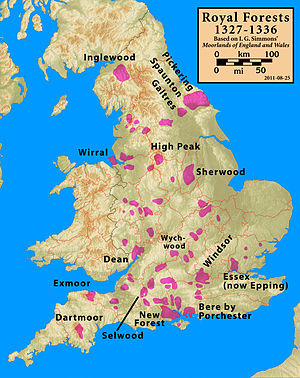
A royal forest was an area reserved by the king for hunting, and William the Conqueror introduced the concept of forest law in England in the 11th century.[1] Until 1204 the whole of Devon was a royal forest, but in that year King John agreed (subject to the payment by the county's commonality of a "fine" of 5,000 marks) to disafforest all of Devon "up to the metes of the ancient regardes of Dertemore and Exmore, as these regardes were in the time of King Henry the First". In other words, all of Devon except for Dartmoor and Exmoor was freed from forest law.[2]
This disafforestation was confirmed by King Henry III in 1217,[3] and in 1239 he granted the Forest of Dartmoor (and the Manor of Lydford) to his brother, Richard, Earl of Cornwall. From that date it technically became a chase, not a forest, though the name did not change.[4] The next year, in a writ dated 13 June 1240, the king directed the Sheriff of Devon and twelve knights of the county to perambulate the Forest to record its exact bounds. This was because Richard had been in dispute with four knights who owned land adjoining the forest. The perambulation (known ever since as "the 1240 Perambulation") took place on 24 July 1240.[3] It was around this time that the first of the Ancient Tenements, such as Babeny, were founded within the Forest.[5]
Richard's son, Edmund inherited the forest, but when he died in 1300 with no heir, the forest reverted to The Crown. King Edward II granted it to his favourite, Piers Gaveston, in 1308; on Gaveston's beheading in 1312, it reverted to The Crown again.[6] Then in 1337 King Edward III granted the forest to Edward, the Black Prince, at the same time as he created him the first Duke of Cornwall,[3] and today, the forest still belongs to the Duchy of Cornwall.[1] A walk that follows the forest bounds as far as possible was set up in 1982.[7]
^ abSandles, Tim. "The Legendary Forest of Dartmoor". Legendary Dartmoor. Archived from the original on 28 September 2011. Retrieved 11 September 2011.
^Brewer 2002, p.15
^ abcBrewer 2002, p.16
^Somers Cocks 1970, p.94
^Somers Cocks 1970, p.96–98
^Milton 2006, p.8
^Cite error: The named reference TDP was invoked but never defined (see the help page).
and 26 Related for: Forest of Dartmoor information
The ForestofDartmoor is an ancient royal forest covering part ofDartmoor, Devon, England. A royal forest was an area reserved by the king for hunting...
since 1951. Dartmoor National Park covers 954 km2 (368 sq mi). The granite which forms the uplands dates from the Carboniferous Period of geological history...
/ 50.592; -3.948 DartmoorForest is a civil parish in Devon, England. It was formed in 1987 by the splitting of the former parish of Lydford. It covers...
HM Prison Dartmoor is a Category C men's prison, located in Princetown, high on Dartmoor in the English county of Devon. Its high granite walls dominate...
Dartmoor Preservation Association (DPA) is one of the oldest environmental or amenity bodies in the UK. It was founded in 1883.: p.3 It concerns itself...
The industrial archaeology ofDartmoor covers a number of the industries which have, over the ages, taken place on Dartmoor, and the remaining evidence...
ForestofDartmoor and the Devon stannaries. The tower was rebuilt in the middle of the 13th century, probably in the 1260s by Richard, the Earl of Cornwall...
Dartmoor, England, established during the 14th century and possibly earlier. In Mediaeval Britain, grazing rights within the boundaries of the Forest...
The Dartmoor crosses are a series of stone crosses found in Dartmoor National Park in the centre of Devon, England. Many of them are old navigational...
about 3 km (1.9 mi) south of Princetown just off the path between Burrator and Whiteworks on the western side ofDartmoor, Devon, England at grid reference...
Cosdon Beacon, or Cawsand Beacon, is one of the highest hills on Dartmoor, in Devon, England. It has numerous traces of prehistoric occupation. Cosdon is a...
Grimspound is a late Bronze Age settlement, situated on Dartmoor in Devon, England. It consists of a set of 24 hut circles surrounded by a low stone wall. The...
Dartmoor; a topographical description of the forest and the commons. Plymouth Western Morning News Co. p. 72. Rowe, Samuel (1898). A perambulation of...
way include New Forest, Exmoor, Dartmoor and Welsh. Fell Ponies are also kept in a semiferal state but managed differently. Each of these breeds also...
rambler, provided a description of the stones in his 1848 book A Perambulation of the Ancient and Royal ForestofDartmoor and the Venville Precincts: We...
The New Forest is one of the largest remaining tracts of unenclosed pasture land, heathland and forest in Southern England, covering southwest Hampshire...
important town, in Devon, seven miles (11 km) north of Tavistock on the western fringe ofDartmoor in the West Devon district. There is an electoral ward...
such as Dartmoor and Exmoor in the South West, and the Peak Forestof Derbyshire. The North Yorkshire moors, a sandstone plateau, had a number of royal...
This is a list ofDartmoor tors and hills. Dartmoor is a National Park in South West England that contains many granite outcrops of many different sizes...
care of English Heritage. List of Cadw properties (Wales) List of Historic Scotland properties List of abbeys and priories List of castles List of Conservation...
the centre ofDartmoor, Devon, England at grid reference SX672731. It lies at the end of the B3357 road, about 4.5 miles (7.2 km) east of Two Bridges...
south Devon, England. From its source on Dartmoor it flows in a generally southerly direction past some of the best-preserved archaeological remains...
bundle of rags to lure children. The pixies ofDartmoor are fond of music, dancing, and riding on Dartmoor colts. These pixies are generally said to be...
Highland, Dartmoor, and Exmoor were introduced to the Forest. This practice ended in 1930, and since that time, only purebred New Forest stallions may...
soils. Moorland, nowadays, generally means uncultivated hill land (such as Dartmoor in South West England), but also includes low-lying wetlands (such as Sedgemoor...
parishes of Sticklepath, South Tawton, DartmoorForest and Okehampton Hamlets. It is only accessible by minor roads from the A30 road, east of the town of Okehampton...
 Global Information