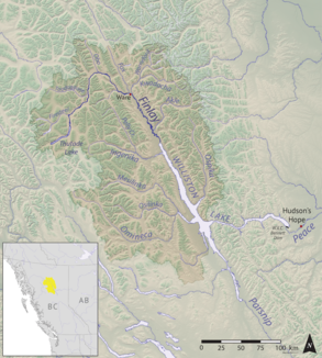
The Finlay River is a 402 km long river in north-central British Columbia flowing north and thence south from Thutade Lake in the Omineca Mountains to Williston Lake, the impounded waters of the Peace River formed by the completion of the W.A.C. Bennett Dam in 1968. Prior to this, the Finlay joined with the Parsnip River to form the Peace. The headwaters of the Finlay at Thutade Lake are considered the ultimate source of the Mackenzie River.[1] Deserters Canyon is located just north of Williston Lake.
The Finlay drains an area of 43,000 square kilometres and discharges at a mean rate of 600 cubic metres per second. Major tributaries of the Finlay include the Ospika, Ingenika, Warneford, Fox, Toodoggone, and Firesteel Rivers (the Ospika now enters Lake Williston directly, however). Located in a remote part of the province, there are no population centres along the river, however, there is a small First Nations community, Fort Ware, located at the junction of the Finlay and Warneford. Tatlatui Provincial Park protects the area of the Tatlatui Range, where Thutade Lake is located.
Map of the Stikine Territory. The line of the Finlay River is the southeast boundary of the territory, which was absorbed into the Colony of British Columbia in 1863.
The Finlay River is named for the explorer John Finlay, who travelled a short way up the river in 1797. The first European to journey its length to its source was the fur trader and explorer Samuel Black in 1824. The river was the eastern half of the northern boundary of the Colony of British Columbia at the time of its creation in 1858, north of which was the North-Western Territory; the western half of the boundary was the Nass River and from 1862 to 1863 it was briefly the southern boundary of the Stickeen Territories (Stikine Territory) which had been formed from the North-Western Territory in response to the Peace and Stikine Gold Rushes and which was amalgamated with the Colony of British Columbia in the following year.
^Atlas of Canada: Rivers of Canada page Archived April 4, 2007, at the Wayback Machine
The FinlayRiver is a 402 km long river in north-central British Columbia flowing north and thence south from Thutade Lake in the Omineca Mountains to...
Peace River joins the Athabasca River in the Peace-Athabasca Delta to form the Slave River, a tributary of the Mackenzie River. The FinlayRiver, the main...
Fraser River, the Parsnip River, the FinlayRiver, the Fox River, and the Kechika River. The North Fork of the Flathead River, flowing into Flathead Lake...
Saskatchewan rivers, which feed into the Nelson. Derived by adding the length of the Peace River (measured from its mouth to the headwaters of the FinlayRiver) to...
the ultimate source of the Mackenzie River. The lake is at the head of the FinlayRiver, which joins the Peace River via Williston Lake. The area is very...
Finlay Forks (also called Finlay Junction and sometimes misspelt Findlay), is the confluence of the FinlayRiver and Parsnip River in British Columbia...
of the Peace River by the W.A.C. Bennett Dam in 1968. Prior to that, the Parsnip joined with the FinlayRiver to form the Peace at Finlay Forks, with both...
at the confluence of the Finlay, Kwadacha and Fox Rivers, in the Rocky Mountain Trench upstream from the end of the Finlay Reach (north arm) of Williston...
Hudson's Bay Company (HBC), who made the first European exploration of the FinlayRiver headwaters, encountered three Tse Keh Nay groups. During the early fur...
Cordillera of north-central British Columbia, Canada. They are bounded by the FinlayRiver on the north, the Rocky Mountain Trench (here filled by Lake Williston)...
Omineca River Osilinka River Mesilinka River Ingenika RiverFinlayRiver Davis River Ospika River Wicked River West Nabesche River Nabesche River Additionally...
of its Finlay Reach. Before the creation of that lake by the building of WAC Bennett Dam, it was a tributary of the FinlayRiver. List of rivers of British...
Bay Company (HBC) for the Columbia District. In 1824, he explored the FinlayRiver and its tributaries in present-day north-central British Columbia, Canada...
the Stikine River, which flows into the Pacific Ocean, and the FinlayRiver, which flows into the Mackenzie via the Peace and Slave Rivers. The primary...
into Williston Lake, and is part of the Peace River basin. It was originally a tributary of the FinlayRiver before the creation of Lake Williston. According...
located just northeast of the foot of Thutade Lake, at the head of the FinlayRiver, in the Omineca Mountains of the Northern Interior of British Columbia...
tributaries of the FinlayRiver. Topographic relief is significant as the summit rises approximately 1,600 meters (5,250 ft) above the FinlayRiver in 5.5 km (3...
parallel to the north, the 125th meridian to the east, the Nass and FinlayRivers to the south, and the panhandle of Russian America to the west (only...
Mountains, located on the northwest side of the junction of Toodoggone River and FinlayRiver in northern British Columbia, Canada. There is also a Peak Range...
on the FinlayRiver in the Omineca region of central British Columbia, Canada. The canyon is just upstream (north) from the tip of the Finlay Arm on Lake...
Skeena River and a fourth route used the Fraser River and crossed over the Giscome Portage to Summit Lake, through McLeod Lake, and up the FinlayRiver to...
layers of phonolitic to trachytic composition in the Dease Lake and FinlayRiver areas of northern British Columbia. Radiocarbon dating of terrestrial...
Toodoggone River is a tributary of the FinlayRiver in the Northern Interior of British Columbia, Canada, flowing east into the upper reaches of the Finlay just...
 Global Information