Map of South Australia and southern Western Australia with Eyre Highway highlighted in red
General information
Type
Highway
Length
1,664 km (1,034 mi)[1]
Opened
1942
Route number(s)
National Highway 1 (1974–present) (Western Australia)
A1 (2017–present) (South Australia)
Former route number
National Highway A1 (1998–2017)
National Highway 1 (1974–1998) (South Australia)
National Route 1 (1955–1974) Entire route
Major junctions
West end
Coolgardie–Esperance Highway Norseman, Western Australia
Flinders Highway
Tod Highway
Lincoln Highway
Stuart Highway
East end
Augusta Highway Port Augusta, South Australia
Location(s)
Major settlements
Eucla, Ceduna, Kyancutta, Kimba
Highway system
Highways in Australia
National Highway • Freeways in Australia
Highways in Western Australia
Highways in South Australia
----
Infobox instructions
guidelines
examples
talk
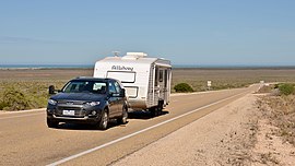
Eyre Highway is a 1,664-kilometre (1,034 mi) highway linking Western Australia and South Australia via the Nullarbor Plain. Signed as National Highways 1 and A1, it forms part of Highway 1 and the Australian National Highway network linking Perth and Adelaide. It was named after explorer Edward John Eyre, who was the first European to cross the Nullarbor by land, in 1840–1841. Eyre Highway runs from Norseman in Western Australia, past Eucla, to the state border. Continuing to the South Australian town of Ceduna, it crosses the top of the Eyre Peninsula before reaching Port Augusta.
The construction of the East–West Telegraph line in the 1870s, along Eyre's route, resulted in a hazardous trail that could be followed for interstate travel. A national highway was called for, with the federal government seeing the route's importance in 1941, when a war in the Pacific seemed imminent. The highway was constructed between July 1941 and June 1942, and was trafficable by January 1942. It was originally named Forrest Highway, after John Forrest, by the war cabinet. It was officially named Eyre Highway, a name agreed upon by the states' nomenclature committees.
The finished road, while an improvement over the previous route, still was not much more than a track, and remained such throughout the 1940s and 1950s. Efforts to seal the highway began in Norseman in 1960, with the Western Australian section completed in 1969 and the South Australian section finished in 1976. Further improvement works have been undertaken since the 1980s, including widening and reconstructing portions of the road.
^Google (29 June 2022). "Eyre Highway" (Map). Google Maps. Google. Retrieved 29 June 2022.
EyreHighway is a 1,664-kilometre (1,034 mi) highway linking Western Australia and South Australia via the Nullarbor Plain. Signed as National Highways...
network of highways. The EyreHighway (Route number A1) runs east–west across the north side of the peninsula, while the Flinders Highway (Route number...
Old EyreHighway is a remnant part of the EyreHighway that was abandoned in the construction of a route closer to the coast of the Great Australian Bight...
straight section of railway in the world (478 km; 297 mi), while the EyreHighway (refer below) contains the longest straight section of tarred road in...
said to be the world's longest, situated along 1,365 kilometres of the EyreHighway along the southern coast of Australia in two states (South Australia...
Look up eyre in Wiktionary, the free dictionary. Eyre may refer to: Eyre (given name) Eyre (surname) EyreHighway, a highway connecting South Australia...
Stuart Highway is a major Australian highway. It runs from Darwin, in the Northern Territory, via Tennant Creek and Alice Springs, to Port Augusta in...
Graeme Highway doubles as flying doctor landing strip 23 July 2015 Government News Retrieved 21 February 2017 RFDS Emergency Landing Strip, EyreHighway, between...
Tod Highway is an important 177 kilometre highway serving South Australia's Eyre Peninsula's wheatbelt, and is designated route B90. It is named after...
Adelaide via the EyreHighway. Approximately halfway along the route is Neale Junction, 172 km (107 mi) west of Ilkurlka, where the highway intersects with...
levels. According to mitochondrial DNA research, Aboriginal people reached Eyre Peninsula 49,000-45,000 years ago from both the east (clockwise, along the...
Reserve, Western Australia. Cocklebiddy is the nearest locality on the EyreHighway, 49 km (30 mi) to the north. It is in the Hampton bioregion, which is...
(200–390 ft) in height, can be viewed from several viewing points along the EyreHighway east of Eucla and west of Nullarbor roadhouse. Geologically the cliffs...
result, highways are concentrated mainly in the southeast. The EyreHighway to Perth and Stuart Highway to Darwin are the only significant highways for the...
Eyre, Eyre Peninsula, Eyre Creek, EyreHighway (the main highway from South Australia to Western Australia), Edward John Eyre High School, the Eyre Hotel...
and EyreHighways. The decades following the war saw substantial improvements to the network, with freeways established in cities, many major highways sealed...
of the major highways have an excellent bitumen surface and other major roads are usually well-maintained dirt roads. The Stuart Highway runs from north...
 Global Information