January 1, 1850 (township) January 1, 1967 (borough) June 1983 (city)
Changed Region
1954 Metropolitan Toronto from York County
Amalgamated
January 1, 1998 into Toronto
Government
• Councillors
Ward councillors
Vincent Crisanti
Mark Grimes
Stephen Holyday
Justin Di Ciano
John Campbell
• MPs
Federal reps
Kirsty Duncan (L)
Yvan Baker (L)
James Maloney (L)
• MPPs
Provincial reps
Doug Ford (PC)
Kinga Surma (PC)
Christine Hogarth (PC)
Area
[1]
• Total
123.93 km2 (47.85 sq mi)
Population
(2016)[1]
• Total
365,143
• Density
2,946.4/km2 (7,631/sq mi)
Demonym
Etobian[1]
Time zone
UTC-5 (EST)
• Summer (DST)
UTC-4 (EDT)
Postal code span
M8V-M9C, M9P-M9R, M9V-M9W
Area code(s)
416, 647, 437
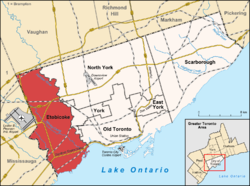
Etobicoke (/ɛˈtoʊbɪkoʊ/ⓘ, eh-TOH-bik-oh) is an administrative district and former city within Toronto, Ontario, Canada. Comprising the city's west-end, Etobicoke is bordered on the south by Lake Ontario, on the east by the Humber River, on the west by Etobicoke Creek, the cities of Brampton, and Mississauga, the Toronto Pearson International Airport (a small portion of the airport extends into Etobicoke), and on the north by the city of Vaughan at Steeles Avenue West.
The area of Etobicoke was first settled by Europeans in the 1790s. Primarily an agricultural district, it was incorporated in 1850 as Etobicoke Township. The municipality grew into city status in the 20th century after World War II. Several independent villages and towns developed and became part of Etobicoke, first when Metropolitan Toronto was formed in 1954, and later, in a 1967 consolidation. In 1998, its city status and government dissolved after it was amalgamated into present-day Toronto.
Etobicoke has a highly diversified population, which totalled 365,143 in 2016. It is primarily suburban in development and heavily industrialized, resulting in a lower population density than the other districts of Toronto. Much of its cityscape is characterized by larger main streets, shopping malls, and cul-de-sac housing developments. Etobicoke has several expressways, including Highways 427, 401, 409, the Queen Elizabeth Way (QEW) and Gardiner Expressway. Etobicoke is the western terminus of Line 2 Bloor-Danforth of the Toronto subway and served by four suburban rail stations of GO Transit. Humber College is in Etobicoke, encompassing two campuses, one of which is also home to the University of Guelph-Humber.
^"Etobian sets record straight". The Toronto Star. February 22, 2007. Retrieved August 19, 2015.
Etobicoke (/ɛˈtoʊbɪkoʊ/ , eh-TOH-bik-oh) is an administrative district and former city within Toronto, Ontario, Canada. Comprising the city's west-end...
Etobicoke North may refer to: Etobicoke North GO Station, a station in the GO Transit network, Etobicoke district, Toronto, Ontario, Canada Etobicoke...
Etobicoke Creek /ɛˈtoʊbɪkoʊ/ is a river in the Greater Toronto Area of Ontario, Canada. It is a tributary of Lake Ontario and runs from Caledon to southern...
municipalities. Along with the original City of Toronto, these are East York, Etobicoke, North York, Scarborough, and York. The names of these municipalities...
Centennial Park in Etobicoke, Toronto, Ontario, Canada during the Canada Day weekend. The Toronto Ribfest is run by the Etobicoke Rotary Club. The festival...
Etobicoke North GO Station is a GO Transit train and bus station on the Kitchener line in the Etobicoke district of Toronto, Ontario, Canada. It is located...
Etobicoke Centre can refer to: Etobicoke Centre (federal electoral district) Etobicoke Centre (provincial electoral district) Islington-City Centre West...
Brampton Etobicoke District Cricket League, popularly known as BEDCL is one of the most popular cricket leagues in Canada, it is the body responsible...
Etobicoke Collegiate Institute (ECI, Etobicoke CI), previously known as Etobicoke High School is a high school in Toronto, Ontario, Canada. It is located...
Dufferin—Peel—Wellington—Grey: Dave Davies Erie—Lincoln: Steve Elgersma Etobicoke—Lakeshore: Ted Kupiec Etobicoke North: Teresa Ceolin Guelph—Wellington: Alan John McDonald...
The Etobicoke General Hospital is a community hospital located at 101 Humber College Boulevard in the Etobicoke district of Toronto, Ontario, Canada....
The Etobicoke School of the Arts (ESA) is a specialized public arts-academic high school in Toronto, Ontario, Canada. Located in Etobicoke, it has been...
following is a list of educational institutions in Etobicoke, a district of Toronto, Ontario, Canada. Etobicoke is a former municipality within Toronto and served...
community councils. Their meeting locations are as follows: Etobicoke and York – Etobicoke Civic Centre North York – North York Civic Centre Scarborough...
Plant". August 2020. Retrieved October 18, 2020. "FCA Canada Fact Sheets - Etobicoke Casting Plant". July 2020. Retrieved October 18, 2020. Official website...
station on Line 1 Yonge–University to the North Campus of Humber College in Etobicoke. The line will operate in a dedicated above-ground right-of-way, much...
years after the centennial. It is located within Centennial Park in the Etobicoke district, just south of Toronto Pearson International Airport and near...
2012. The team was formed as Nobleton Capitals in 1984 and later as the Etobicoke Capitals. Since moving to Brampton in 1989, the Capitals have been one...
The Etobicoke Civic Centre in the Eatonville neighbourhood of Toronto, Ontario, Canada, once housed the municipal government of the former City of Etobicoke...
after his term as mayor, Ford was a city councillor representing Ward 2 Etobicoke North. He was first elected to Toronto City Council in the 2000 Toronto...
Etobicoke Creek is a bus rapid transit station on the Mississauga Transitway in Mississauga, Ontario, Canada. It is located along the north side of Eglinton...
 Global Information