The Enguri (Georgian: ენგური, romanized:enguri, Mingrelian: ინგირი, romanized: ingiri, Abkhaz: Егры, Egry Russian: Ингури, Inguri) is a river in western Georgia. It is 213 km (132 mi) long, and has a drainage basin of 4,060 km2 (1,570 sq mi).[1] It originates near Ushguli in northeastern Svaneti and plays an important role providing hydroelectric power to the area.
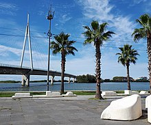
The Enguri ValleyBridge over the Enguri river near the coast. In the background the area of AbkhaziaMouth of Enguri river with viewtower, September 2018
The river emerges from the high Caucasus near the highest mountain in Georgia, Shkhara, and winds through the mountain valleys to the northwest before turning southwest to empty into the Black Sea near Anaklia.
Since the Abkhaz–Georgian conflict, both Georgia and Abkhazia keep troops on the river; Russia also keeps peacekeeping troops. The only legal crossing-point is the 870-metre (2,850 ft) long Enguri Bridge [ru], which was built by German prisoners of war from 1944 until 1948. There are also a number of illegal connections across the river.
The river plays an important role in the Georgian energy production. In 1988 the Enguri Dam was built at a height of 240 metres (790 ft). At 750 metres (2,460 ft) across and 271.5 metres (891 ft) high, it is the largest construction in the Caucasus. It has a capacity of 1.1 million cubic metres (39,000,000 cu ft) of water. The underground water works produce about 40% of the national energy. The capacity is 1,300 megawatts.
^Statistical Yearbook of Georgia: 2020, National Statistics Office of Georgia, Tbilisi, 2020, p. 12.
The Enguri (Georgian: ენგური, romanized: enguri, Mingrelian: ინგირი, romanized: ingiri, Abkhaz: Егры, Egry Russian: Ингури, Inguri) is a river in western...
The Enguri Dam is a hydroelectric dam on the Enguri River in Tsalenjikha, Georgia. Currently, it is the world's second highest concrete arch dam, with...
December 2, 2001, with the discovery of two orphan radiation sources near the Enguri Dam in Tsalenjikha District in the country of Georgia. Three villagers from...
multiple-arch type) Contra Dam Daniel-Johnson Dam Deriner Dam El Atazar Dam Enguri Dam Flaming Gorge Dam Glen Canyon Dam Hartbeespoort Dam Idukki Dam Kariba...
is located in the Samegrelo-Zemo Svaneti region, at the place where the Enguri River flows into the Black Sea, near the border with Abkhazia. The earliest...
two broad upland valleys located to the south of Mount Elbrus – the upper Enguri River valley in the west and the upper Ts'khenis-Ts'k'ali and its tributary...
(Georgian: უშგული) is a community of five villages located at the head of the Enguri gorge in Svaneti, Georgia. Ushguli is one of the highest continuously inhabited...
Svaneti, i.e. in the districts of Mestia and Lentekhi of Georgia, along the Enguri, Tskhenistsqali and Kodori rivers. Some Svan speakers live in the Kodori...
plants in the Gali Municipality of Georgia. Included in the Cascade of Enguri Hydropower Plants. It consists of four relatively smaller power plants (Vardnil...
dumped behind, unlabeled and improperly dismanteled, near the Soviet-built Enguri Dam. Three villagers from the nearby village of Lia were unknowingly exposed...
Tkvarcheli and terminates near the village of Lekukhona on the right bank of Enguri. Most of the fortifications are located in the western part of the wall...
total area of the glaciers of Georgia is a share of the Enguri River basin. Except the Enguri River basin the shares of the other river basins in the...
possessions in the east, first to the river Ghalidzga, and then to the Enguri, which serves as today's boundary between Abkhazia and Georgia proper. After...
the southern foothills of the Greater Caucasus mountains, in the upper Enguri River valley, at the elevation of 2,160 m above sea level. The village is...
Potskhetseri (Georgian ფოცხოეწერი) is a village near the Enguri Dam in the Tsalenjikha Municipality of Samegrelo-Zemo Svaneti region of western Georgia...
Railway. Lines from Nikozi to Tskhinvali (5 km) and from Ochamchire to Enguri River are not in use; much of the track and overhead on these two lines...
Tsalenjikha. Tsalenjikha Municipality is located in the valleys of the Enguri and Chanistskali rivers, the area is 646.7 km2, the population is 26,158...
Russian state. Samurzakano was an ethnical contact zone located between the Enguri and Ghalidzga rivers, where already in the 18th century a mixed Abkhaz-Georgian...
 Global Information