Global Information Lookup Global Information

Electoral district of Ripon information


Ripon
Victoria—Legislative Assembly
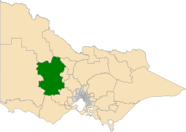
Location of Ripon (dark green) in Victoria
StateVictoria
Dates current1945–1955
1976–present
MPMartha Haylett
PartyLabor
NamesakeShire of Ripon
Electors47,774 (2018)
Area14,444 km2 (5,576.9 sq mi)
DemographicRural
Coordinates36°57′0″S 143°15′36″E / 36.95000°S 143.26000°E / -36.95000; 143.26000
Electorates around Ripon:
Lowan Mildura Murray Plains
Bendigo East
Lowan Ripon Bendigo West
Macedon
Lowan Eureka
Polwarth
Wendouree
Eureka

Ripon is a single member electoral district of the Victorian Legislative Assembly. It is a rural electorate based in western Victoria. In 1946 the electoral district of Ripon was first contested but then abolished in the 1955 election after being held by Labor for seven of these years.[1] Ripon was re-created in 1976,[1] essentially as a replacement for Hampden and Kara Kara.

Ripon has an area of 16,761 square kilometres.[2] It includes the towns of Amphitheatre, Ararat, Avoca, Bealiba, Beaufort, Borung, Bridgewater on Loddon, Buangor, Cardigan, Carisbrook, Charlton, Clunes, Creswick, Dunolly, Eddington, Elmhurst, Glenorchy, Great Western, Inglewood, Landsborough, Lexton, Lucas, Marnoo, Maryborough, Miners Rest, Moonambel, Newbridge, Snake Valley, St Arnaud, Stawell, Stuart Mill, Talbot, Tarnagulla and Wedderburn.[2] The main population centres are Creswick, Ararat, Maryborough, Avoca, Bridgewater on Loddon, St Arnaud and Stawell.[1] This district is known for agriculture, wine making, timber industries, manufacturing, wool production, paper milling, knitting mills and tourism.[2]

It has been held by the Liberal Party for most of its history. However, it was one of several country seats that unexpectedly fell to Labor Party in 1999 as part of Labor's shock victory that year. Labor would hold the seat until 2014, and reclaimed it in 2022. The 2018 result was the subject of a legal challenge by the second placed Labor candidate.[3]

In the 2021 redistribution, the boundaries of Ripon moved southeast, losing Donald and Charlton to Mildura, and Stawell to Lowan, and also gaining rural towns to the north, west and southwest of Ballarat from the abolished district of Buninyong. As a result, it is estimated that Ripon would be a Labor marginal seat from results of the 2018 election with a margin of 2.8%.[4]

  1. ^ a b c "Victorian Election 2014". ABC. Retrieved 12 February 2015.
  2. ^ a b c "Ripon District profile". Victorian Electoral Commission. Retrieved 12 February 2015.[permanent dead link]
  3. ^ Wilson, Amber (7 February 2019). "De Santis' lawyer says she should've won Ripon: court". Collie Mail.
  4. ^ "Map of Ripon District" (PDF). Victorian Electoral Boundaries Commission.

and 21 Related for: Electoral district of Ripon information

Request time (Page generated in 1.1132 seconds.)

Electoral district of Ripon

Last Update:

Ripon is a single member electoral district of the Victorian Legislative Assembly. It is a rural electorate based in western Victoria. In 1946 the electoral...

Word Count : 379

Electoral district of Ripon and Hampden

Last Update:

Ripon and Hampden was an electoral district of the Legislative Assembly in the Australian state of Victoria from 1859 to 1904. It was based in western...

Word Count : 173

Electoral results for the district of Ripon

Last Update:

This is a list of electoral results for the Electoral district of Ripon in Victorian state elections. The 2018 result was the subject of a legal challenge...

Word Count : 116

Ripon

Last Update:

Ripon (/ˈrɪpən/) is a cathedral city and civil parish in North Yorkshire, England. The city is located at the confluence of two tributaries of the River...

Word Count : 5935

List of electoral wards in North Yorkshire

Last Update:

list of electoral divisions and wards in the ceremonial county of North Yorkshire in Yorkshire and the Humber. All changes since the re-organisation of local...

Word Count : 4230

Electoral district of Kara Kara

Last Update:

abolished in 1976 and replaced by the electoral district of Ripon. Kara Kara was abolished in 1927, the Electoral district of Kara Kara and Borung was created...

Word Count : 140

List of close election results

Last Update:

Springer. ISBN 9781349814671. "State Election 2018: Ripon District results summary - Victorian Electoral Commission". vec.vic.gov.au. Retrieved 2018-12-04...

Word Count : 8435

Electoral district of Polwarth and South Grenville

Last Update:

was created after the Electoral district of Polwarth, Ripon, Hampden and South Grenville was divided in 1859. After the abolition of Polwarth and South Grenville...

Word Count : 167

Electoral district of Wendouree

Last Update:

district of Ripon and the Yarrowee River with the district of Eureka. District profile from the Victorian Electoral Commission "Summary of Changes"....

Word Count : 273

Electoral district of Northcote

Last Update:

The electoral district of Northcote /ˈnɔːθkət/ is an electoral district of the Victorian Legislative Assembly. It covers the suburbs of Alphington, Fairfield...

Word Count : 336

Electoral district of Grenville

Last Update:

"Electoral district of Polwarth, Ripon, Hampden and South Grenville" and "Electoral district of North Grenville" which were both original districts of...

Word Count : 250

Electoral district of North Grenville

Last Update:

North Grenville was an electoral district of the Legislative Assembly in the Australian state of Victoria from 1856 to 1859. It was bordered on the east...

Word Count : 151

Electoral district of North Grant

Last Update:

North Grant was an electoral district of the Legislative Assembly in the Australian state of Victoria from 1856 to 1859. It was bordered on the north...

Word Count : 155

Electoral district of Burwood

Last Update:

The electoral district of Burwood was an electorate for the Victorian Legislative Assembly in Australia. It was located approximately 13 kilometres east...

Word Count : 260

Electoral district of Eltham

Last Update:

The electoral district of Eltham is an electoral district of the Victorian Legislative Assembly. It is an outer metropolitan electorate and contains Eltham...

Word Count : 154

Electoral district of Morwell

Last Update:

The electoral district of Morwell is an electoral district of the Victorian Legislative Assembly. It covers the regional centres of Moe, Morwell and Traralgon...

Word Count : 160

Electoral district of Villiers and Heytesbury

Last Update:

Rutledge Esq" (PDF). Parliament of Victoria. 14 May 1861. "Electoral Districts of South Grant, North Grant, North Grenville, Ripon, Hampden, South Grenville...

Word Count : 177

Electoral district of Broadmeadows

Last Update:

The electoral district of Broadmeadows is an electorate of the Victorian Legislative Assembly. It covers an area of 47 square kilometres (18 sq mi) in...

Word Count : 512

List of cities in the United Kingdom

Last Update:

the city of Ripon; though the status may not apply to the local government district which share their name. For example, the civil parishes of Lichfield...

Word Count : 5052

Electoral district of Wimmera

Last Update:

Source; and on the South by the Boundaries of the Counties of Follett, Dundas and Ripon". In the Electoral Act of 1858 (which took effect in 1859), Wimmera...

Word Count : 248

Electoral district of Preston

Last Update:

The electoral district of Preston is an electoral district of the Victorian Legislative Assembly. It currently centres on the northern Melbourne suburbs...

Word Count : 129

PDF Search Engine © AllGlobal.net