Global Information Lookup Global Information

Edisto River information


Feeding ducks in winter time at Edisto Gardens alongside the Edisto River, Orangeburg, South Carolina
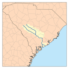
Edisto River watershed
Edisto River is located in South Carolina
Edisto River
Location of mouth
Location
CountryUnited States
StateSouth Carolina
CountiesCharleston, Colleton, Dorchester, Bamberg, Orangeburg
Physical characteristics
Source 
 • coordinates33°15′46″N 80°53′11″W / 33.262659°N 80.8864854°W / 33.262659; -80.8864854
Mouth 
 • location
Edisto Beach, Atlantic Ocean
 • coordinates
32°39′16″N 80°23′17″W / 32.65444°N 80.38806°W / 32.65444; -80.38806
 • elevation
0 ft (0 m)
Lengthover 250 mi (400 km)

The Edisto River is one of the longest free-flowing blackwater rivers in North America,[1] flowing over 250[1] meandering miles from its sources in Saluda and Edgefield counties, to its Atlantic Ocean mouth at Edisto Beach, South Carolina. It rises in two main tributaries (North Fork & South Fork) from springs under the Sandhills region of West Central South Carolina, just to the south of the Piedmont Fall Line. It is the longest and largest river system completely contained within the borders of South Carolina. Its name comes from the Edisto subtribe of the Cusabo Indians.[2]

Near the coast, part of the river was once known as the Ponpon River. The Dawhoo River (sometimes Dawho, or Dawhoe) connects the Edisto to the North Edisto River, also the confluence of the Wadmalaw and the Toogoodoo rivers, where they meet the Atlantic Ocean. Between the coast and the Dawhoo River, the river is known as the South Edisto River.[3]

The Edisto system flows through only one major town or city, Orangeburg, the location of Edisto Gardens (on the North Fork). The river system, being blackwater throughout its entire length, flows through highly intermittent bottom swampland. During an excessively rainy season, the river will leave its main channel, with its flow basin increasing to over a mile or more of total width. The lower Edisto basin forms a crucial part of the ACE Basin, an area that encompasses its bottomlands confluence with the Ashepoo and Combahee river basins.[4]

A major tributary is Four Holes Swamp, which is unique in that it has no single defined channel, but rather a network of braided channels.

  1. ^ a b "South Carolina Department of Natural Resources - Edisto River". Archived from the original on June 21, 2012. Retrieved May 8, 2012.
  2. ^ U.S. Geological Survey Geographic Names Information System: Edisto River
  3. ^ Report of the Chief of Engineers U.S. Army, 1881, Volume II, page 1140.
  4. ^ "ACE Basin National Wildlife Refuge". ACE.

and 20 Related for: Edisto River information

Request time (Page generated in 0.7906 seconds.)

Edisto River

Last Update:

The Edisto River is one of the longest free-flowing blackwater rivers in North America, flowing over 250 meandering miles from its sources in Saluda and...

Word Count : 734

Edisto Island

Last Update:

County. Edisto Beach is in Colleton County, and the Charleston County part of the island is unincorporated. The island, the town, and the Edisto River are...

Word Count : 1676

Blackwater river

Last Update:

Albemarle Sound. Edisto River, South Carolina: flows into the Atlantic Ocean. Econlockhatchee River, a tributary of the St. Johns River in Central Florida...

Word Count : 2095

List of rivers of South Carolina

Last Update:

Creek Wando River Cooper River Back River Ashley River Stono River Kiawah River Edisto River (North Edisto River and South Edisto River are distributaries)...

Word Count : 555

Ashepoo Combahee Edisto Basin National Estuarine Research Reserve

Last Update:

The Ashepoo Combahee Edisto Basin National Estuarine Research Reserve (often shortened to ACE Basin NERR) is a 140,000-acre (570 km2) reserve area located...

Word Count : 323

Stono River

Last Update:

between the mainland and Wadmalaw Island and Johns Island, from north Edisto River between Johns (West) and James (East) Islands. The Intracoastal Waterway...

Word Count : 191

Combahee River

Last Update:

of its lower drainage basin combines with the Ashepoo River and the Edisto River to form the ACE Basin. The Combahee empties into Saint Helena Sound near...

Word Count : 537

Stono Rebellion

Last Update:

being intercepted and defeated by the South Carolina militia near the Edisto River. Survivors traveled another 30 miles (50 km) before the militia finally...

Word Count : 2536

Edisto Island during the American Civil War

Last Update:

Edisto Island during the American Civil War was the location of a number of minor engagements and for a time of a large colony of escaped African-American...

Word Count : 2636

Interstate 95 in South Carolina

Last Update:

Marion crosses. United States portal U.S. roads portal Edisto River Lake Marion Pee Dee River South of the Border South Carolina Highway Patrol Starks...

Word Count : 1578

South Carolina

Last Update:

names of these tribes survive in place names like Edisto Island, Kiawah Island, and the Ashepoo River. The Spanish were the first Europeans in the area...

Word Count : 11793

Chattooga River

Last Update:

Chattooga River (also spelled Chatooga, Chatuga, and Chautaga, variant name Guinekelokee River) is the main tributary of the Tugaloo River. The headwaters...

Word Count : 1500

Ashepoo River

Last Update:

with the Combahee and Edisto river basins. (The refuge's name is formed from the first letters of the names of the three rivers: A-C-E). The name comes...

Word Count : 308

ACE Basin

Last Update:

Beaufort counties in South Carolina, the Ashepoo, Combahee and South Edisto rivers combine into the larger St. Helena Sound and drain a significant portion...

Word Count : 1182

Wadmalaw Island

Last Update:

the northeast and east by Bohicket Creek; to the south by the North Edisto River; and to the west by the Bohicket Creek. The island's only connection...

Word Count : 549

Givhans Ferry State Park

Last Update:

A boat drop off area allows small boats access to the Edisto River. The multi-purpose River Bluff Nature Trail is available for hiking and biking. Amenities...

Word Count : 254

Congaree National Park

Last Update:

Park. Resource extraction on the Congaree River centered on cypress logging from 1898 when the Santee River Cypress Logging Company began to operate in...

Word Count : 1476

Hurricane Idalia

Last Update:

areas along the Edisto and Combahee rivers in Colleton and Dorchester counties, with water levels peaking at 14.5 feet (4.4 m) at a river gauge at Givhans...

Word Count : 6649

Bloody Bill Cunningham

Last Update:

all along the river. Pickens easily took the first camp by surprise but the rest heard the alarm and successfully escaped. Edisto River signaled Cunningham's...

Word Count : 1910

Croft State Park

Last Update:

Tract Cliff Pitts Clinton Reservoir Tract Crackerneck Donnelley Draper Edisto River Fant's Grove Gray Court Tract Hamilton Ridge Hatchery Herbert Kirsh Hickory...

Word Count : 543

PDF Search Engine © AllGlobal.net