The western part of Dundry village seen from the top of the church tower in 2004The west part of East Dundry in 1962The East Dundry baby nearly bombed during his 24 November 1940 Christening in Bristol
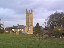
Dundry is a village and civil parish, situated on Dundry Hill in the northern part of the Mendip Hills, between Bristol and the Chew Valley Lake, in the English county of North Somerset, previously Somerset. The parish includes the hamlets of Maiden Head and East Dundry. The parish had a 2011 population of 829.[1]
The village lies on the route of the Monarch's Way long-distance footpath. It is a popular destination for the people of Bristol as it is known for its panoramic views of the city.
^ ab"2011 Census Profile". North Somerset Council. Archived from the original (Excel) on 4 January 2014. Retrieved 4 January 2014.
Dundry is a village and civil parish, situated on Dundry Hill in the northern part of the Mendip Hills, between Bristol and the Chew Valley Lake, in the...
Dundry Hill is immediately south of Bristol, England: it includes farmland, a small number of houses and a church. It stretches east–west for some two...
Dundry Main Road South Quarry (grid reference ST566654) is a 0.7 hectare geological Site of Special Scientific Interest near the village of East Dundry...
East Dundry is a south-facing hamlet some 160 metres above sea level in a sheltered valley of Dundry Hill just south of Bristol, England. The hamlet is...
the Elder Lady Chapel, is made from limestone taken from quarries around Dundry and Felton with Bath stone being used in other areas. Amongst the other...
on 1 April 1951 and merged with Bristol, parts went to Long Ashton and Dundry. In 1931 the parish had a population of 1866. In 1928 the ecclesiastical...
Barns Batch Spinney, a geological Site of Special Scientific Interest near Dundry, Somerset, England Beacon Batch, the summit area of Black Down, the highest...
eastern end of the Dundry Down ridge, south of the city of Bristol and north of the village of Norton Malreward near the eastern side of Dundry Hill. It is a...
Dorset. Until about 1958 when the mains water arrived, the hamlet of East Dundry just south of Bristol had three working rams – their noisy "thump" every...
north side of Dundry Hill on the borders of Somerset and Bristol. The main tributary is the Pigeonhouse stream which also rises on Dundry. Much of the...
from Beckford's Tower in Bath and from the tower of St Michael's Church, Dundry near Bristol.[citation needed] A car park on Bratton Road (B3098) which...
Knighton Sutton, North Elm, and Stone. Furthermore, it had the living of Dundry annexed to it. By 1848 all tithes had been commuted and the sole impropriator...
North East Somerset, North Somerset, Somerset BS41 BRISTOL Long Ashton, Dundry North Somerset BS48 BRISTOL Backwell, Nailsea North Somerset BS49 BRISTOL...
Clapton in Gordano, Claverham, Cleeve, Clevedon, Congresbury Downside, Dundry East End, East Hewish, East Rolstone, Easton in Gordano Failand, Farleigh...
06-hectare geological Site of Special Scientific Interest near the village of Dundry, North Somerset, notified in 1987. The English Nature citation says that...
house. The stonework which remains from the medieval period is primarily Dundry stone from Somerset, though local blue lias constitutes most of the stonework...
generally low-lying and undulating. It is bounded by higher ground ranging from Dundry Down and the south western boundary of Keynsham town to the north, the Lulsgate...
Part of an 1842 tithe map including the small village of East Dundry near Bristol, England, with names of its fields and two farms. Note the tithe-officer...
evidence for its western extension is earthworks along the north side of Dundry Hill, its mention in a charter and a road name. The area became the border...
Lincolnshire 168 162 Normanby le Wold Top TF121964 43 Bristol 160 east of Dundry Hill ST593668 44 Essex 147 Chrishall Common TL443362 45 Cambridgeshire 146...
 Global Information