Global Information Lookup Global Information

Duilong River information


Duilong River
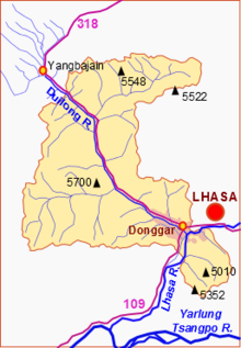
Sketch map of the Duilong River and Doilungdêqên District
Location
CountryTibet
LocationDamxung County, Doilungdêqên District, Lhasa
Physical characteristics
Mouth 
 • coordinates
29°37′11″N 91°00′39″E / 29.619711°N 91.010815°E / 29.619711; 91.010815
Length137 km (85 mi)
Basin size4,988 km2 (1,926 sq mi)
Basin features
River systemLhasa River

The Duilong River, or Duilong Qu (Toelung, Tibetan: སྟོད་ལུང་ཆུ, Wylie: stod lung chu; Chinese: 堆龙河), is a right tributary of the Lhasa River, which it enters just below the city of Lhasa, Tibet, China. The river is about 137 kilometres (85 mi) in length. Water quality may be compromised by dissolved substances including arsenic from geothermal springs.

and 5 Related for: Duilong River information

Request time (Page generated in 0.8145 seconds.)

Duilong River

Last Update:

The Duilong River, or Duilong Qu (Toelung, Tibetan: སྟོད་ལུང་ཆུ, Wylie: stod lung chu; Chinese: 堆龙河), is a right tributary of the Lhasa River, which it...

Word Count : 685

Lhasa River

Last Update:

Pengbo River and the Duilong River. At its mouth the Lhasa Valley is about 3 miles (4.8 km) wide. It enters the Tsangpo at a point where that river makes...

Word Count : 2575

Tsurphu River

Last Update:

Autonomous Region, the People's Republic of China. Tsurphu River is the right bank tributary of Duilong River, originated in the town of Gurong southwest of Zagara...

Word Count : 219

Yangbajain Geothermal Field

Last Update:

Lhasa in 1981 along a transmission line that runs southeast along the Duilong River. It was the main source of power for Lhasa until the Yamdrok Hydropower...

Word Count : 1541

Damxung County

Last Update:

to the city of Lhasa to the south. The transmission line follows the Duilong River south through Doilungdêqên District. Yangbajain Geothermal Field is...

Word Count : 1505

PDF Search Engine © AllGlobal.net