 Global Information
Dudhatoli information
| Dudhatoli Range | |
|---|---|
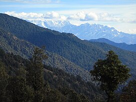 View of Brahma-dhungi (The giant rock at the centre of the image) in the southern flank of Dudhatoli mountains with the great Himalayas in the background; as seen from Peethsain in Pauri Garhwal | |
| Highest point | |
| Peak | Musa Ka Kotha |
| Elevation | 3,114 m (10,217 ft) |
| Parent peak | Dudhatoli Danda |
| Coordinates | 30°03′56″N 79°11′13″E / 30.06556°N 79.18694°E |
| Dimensions | |
| Length | 25 km (16 mi) |
| Width | 20 km (12 mi) |
| Naming | |
| Etymology | from "Doodh ki Tauli" in Garhwali ("Cauldron of Milk" in English) |
| Native name | दुधतोलि डांडा (Garhwali) |
| Geography | |
| Country | |
| State | Uttarakhand |
| Region | Pauri Garhwal , Chamoli Garhwal |
| Rivers | Nayaar (East), Nayaar (West), Ramganga (West), Aata Gaad, Bino and Dhaijyuli Gaad |
| Settlements | Thalisain and Gairsain |
| Geology | |
| Type of rock | Fold mountains from Plate tectonics |
Dudhatoli is a middle Himalayan mountain range/forest running approximately 25 km in a north–south direction, starting near Thalisain tehsil of Pauri Garhwal district in Uttarakhand, with Gairsain in Chamoli district being its western limit and Syoli-Khand region in Pauri its northernmost spur.[1][2]
Some off-shoots of the parent mountain range go as far North as Nauti-Chhatoli-Nandasain in Chamoli, Paithani (Pauri Garhwal) in the West and Mehalchauri/Milchori (Chamoli) in South-East. Musa-ka-kotha,[3] the highest peak in Dudhatoli range, is higher than Nag Tibba[4] (often wrongly quoted as the highest peak in the Shivaliks) by almost hundred metres. The core area of Dudhatoli mountains, known as Dudhatoli Danda has an average elevation of 2900 to 3000 metres (9500 to 10000 feet).

- ^ RAVLEEN KAUR (22 October 2011). "A people's forest". thehindu.com. The Hindu. Archived from the original on 7 May 2013. Retrieved 15 October 2018.
- ^ "Binsar Mahadev Temple". pauri.nic.in. Pauri Garhwal, Government of Uttarakhand .
- ^ "{title}" (PDF). Archived from the original (PDF) on 13 October 2018. Retrieved 15 October 2018.
- ^ "Treks in Himalaya" (PDF). treksinhimalaya.com. Archived (PDF) from the original on 25 August 2018. Retrieved 15 October 2018.