 Global Information
Drygrange Old Bridge information
Drygrange Old Bridge | |
|---|---|
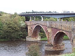 | |
| Coordinates | 55°36′14″N 2°40′32″W / 55.603915°N 2.675603°W |
| Crosses | River Tweed |
| Characteristics | |
| Material | Stone |
| Longest span | 105 feet (32 m) |
| No. of spans | 4 |
| History | |
| Construction start | 1776 |
| Construction end | 1780 |
| Location | |
 | |
The Drygrange Old Bridge is a disused road bridge over the River Tweed near Melrose in the Scottish Borders.