 Global Information
Drumuillie information
Drumuillie
| |
|---|---|
 The A95 at Drumuillie in winter | |
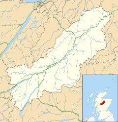 Drumuillie Location within the Badenoch and Strathspey area | |
| OS grid reference | NH947199 |
| Council area |
|
| Country | Scotland |
| Sovereign state | United Kingdom |
| Postcode district | PH24 3 |
| Police | Scotland |
| Fire | Scottish |
| Ambulance | Scottish |
Drumuillie (Scottish Gaelic: Druim Mùillidh) is a small hamlet (or Clachan), which lies 1 mile (1.6 km) north of Boat of Garten and 10 miles (16 km) northeast of Aviemore in Inverness-shire, Scottish Highlands and is in the Scottish council area of Highland.[1] The village is located at the centre of Abernethy Forest (to the north of Drumuillie is Deishar Wood)[2] and just to the west of the River Spey.
- ^ "Drumuillie". The Gazetteer for Scotland. School of GeoSciences, University of Edinburgh and The Royal Scottish Geographical Society. Retrieved 17 June 2018.
- ^ Historic Environment Scotland. "Deishar Wood (15455)". Canmore. Retrieved 8 September 2021.