 Global Information
Dowa Yalanne information
| Dowa Yalanne | |
|---|---|
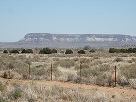 Dowa Yalanne, the "Corn Mountain" of the Zuni people | |
| Highest point | |
| Elevation | 7,274 ft (2,217 m) NGVD 29[1] |
| Coordinates | 35°03′10″N 108°47′32″W / 35.0528111°N 108.7923046°W[2] |
| Geography | |
 Dowa Yalanne Location in New Mexico | |
| Location | McKinley County, New Mexico, U.S. |
| Topo map | USGS Zuni |
Dowa Yalanne (Zuni: "Corn Mountain") is a steep mesa 3.1 miles (5 km) southeast of the present Pueblo of Zuni, on the Zuni Indian Reservation. Plainly visible from the Zuni Pueblo, the mesa is located in McKinley County, New Mexico,[3] and has an elevation of 7,274 feet (2,217 m). The mesa is a sacred place for the Zuni people, who fled to the mesa top to escape the Coronado expedition in 1540, and it is closed to outside visitors.
- ^ "Dowa Yalanne". ListsOfJohn.com. Retrieved 2014-02-15.
- ^ "Dowa Yalanne". Geographic Names Information System. United States Geological Survey, United States Department of the Interior. Retrieved 2014-02-15.
- ^ "ZYEP – Zuni Youth Enrichment Project: The Zuni Pueblo". Retrieved 2014-02-04.