Global Information Lookup Global Information

Dietzenley information


Dietzenley
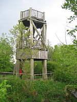
Viewing tower on the Dietzenley
Highest point
Elevation617.6 m above sea level (NHN) (2,026 ft) [1]
Coordinates50°12′09″N 6°40′40″E / 50.2025°N 6.67778°E / 50.2025; 6.67778
Geography
Dietzenley is located in Rhineland-Palatinate
Dietzenley
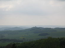
Dietzenley
Vulkaneifel county, Rhineland-Palatinate, Germany
(Viewing tower at the summit)
Parent rangeVolcanic Eifel
Geology
Mountain typevolcano
Type of rockBasalt

The Dietzenley in the county of Vulkaneifel in the German state of Rhineland-Palatinate is a mountain, 617.6 m above sea level (NHN),[1] and the highest point in the Pelm Forest, a part of the Volcanic Eifel range.

The Dietzenley rises within the Volcanic Eifel Nature Park in the parish of Gerolstein north and above the Gerolstein quarter of Büscheich-Niedereich.

On the largely wooded domed summit stands a small, wooden observation tower, which offers a good view of the Volcanic Eifel. Somewhat below it there is an electrical converter and the remains of a Celtic ringwall.

The Dietzenley may be reached on footpaths from Gerolstein, Pelm or Gees.

View of the Alter Voß from the tower
  1. ^ a b Map service of the Landscape Information System of the Rhineland-Palatinate Nature Conservation Office (Naturschutzverwaltung Rheinland-Pfalz)

and 6 Related for: Dietzenley information

Request time (Page generated in 0.5092 seconds.)

Dietzenley

Last Update:

The Dietzenley in the county of Vulkaneifel in the German state of Rhineland-Palatinate is a mountain, 617.6 m above sea level (NHN), and the highest point...

Word Count : 127

Volcanic Eifel

Last Update:

volcanic (eponymous quartzite ridge; other summits being the Scharteberg and Dietzenley) Hochkelberg, 674.9 m (2,210 ft), county of Vulkaneifel; with a transmission...

Word Count : 982

Eifel

Last Update:

Adert, Hohe Acht and Raßberg in the northeast; the Hochkel, Nerotherkopf, Dietzenley and ruins of the Kasselburg in the central area; the Prümer Kalvarienberg...

Word Count : 8205

Gerolstein

Last Update:

human habitation in the Buchenloch, a nearby cave. In the Bronze Age the Dietzenley was used by the Celts as a refuge castle. In Roman times a temple and...

Word Count : 3013

List of castles in the Eifel

Last Update:

rampart Borler DAU RP Circular rampart Probably early Celtic Image wanted Dietzenley circular rampart Gerolstein DAU RP Iron Age circular rampart Remains Image...

Word Count : 310

List of mountains and hills of the Eifel

Last Update:

Hills Ahrweiler Highest elevation of the Ahr Hills; site of Burg Aremberg Dietzenley 617.6 Volcanic Eifel Vulkaneifel Highest mountain of the Pelmer Forest...

Word Count : 126

PDF Search Engine © AllGlobal.net