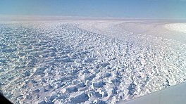
Denman Glacier is a glacier 11 to 16 km (7 to 10 mi) wide, descending north some 110 km (70 mi), which debouches into the Shackleton Ice Shelf east of David Island, Queen Mary Land. It was discovered in November 1912 by the Western Base party of the Australasian Antarctic Expedition under Sir Douglas Mawson. Mawson named the glacier for Lord Denman, Governor-General of Australia in 1911, a patron of the expedition.[1]
The canyon under Denman Glacier has been found by the BedMachine Antarctica project (under the leadership of the University of California, Irvine)[2] to be the deepest natural location on land (or at least not under liquid water) worldwide, with the bedrock being 3,500 m (11,500 ft) below sea level.[3][4]
Calving of Denman Glacier into the Mawson Sea gives rise to the periodically appearing Pobeda Ice Island.
^"Denman Glacier". Geographic Names Information System. United States Geological Survey, United States Department of the Interior. Retrieved 2012-01-11.
^"So that's what it's like beneath Antarctica's ice sheet: New high-precision map reveals all the bumps and hollows". Cosmos magazine. 2019-12-13. Retrieved 2019-12-13.
^Jonathan Amos (December 12, 2019). "Denman Glacier: Deepest point on land found in Antarctica". BBC. Retrieved December 13, 2019.
^Mathieu Morlighem; Eric Rignot; Tobias Binder; Donald Blankenship; Reinhard Drews; Graeme Eagles; Olaf Eisen; Fausto Ferraccioli; René Forsberg; Peter Fretwell; Vikram Goel; Jamin S. Greenbaum; Hilmar Gudmundsson; Jingxue Guo; Veit Helm; Coen Hofstede; Ian Howat; Angelika Humbert; Wilfried Jokat; Nanna B. Karlsson; Won Sang Lee; Kenichi Matsuoka; Romain Millan; Jeremie Mouginot; John Paden; Frank Pattyn; Jason Roberts; Sebastian Rosier; Antonia Ruppel; Helene Seroussi; Emma C. Smith; Daniel Steinhage; Bo Sun; Michiel R. van den Broeke; Tas D. van Ommen; Melchior van Wessem; Duncan A. Young (2019-12-12). "Deep glacial troughs and stabilizing ridges unveiled beneath the margins of the Antarctic ice sheet". Nature Geoscience. 13 (2): 132–137. doi:10.1038/s41561-019-0510-8. S2CID 209331991. Retrieved 2019-12-13.
DenmanGlacier is a glacier 11 to 16 km (7 to 10 mi) wide, descending north some 110 km (70 mi), which debouches into the Shackleton Ice Shelf east of...
the World. Two important glaciers debouche into the water here: Scott Glacier and DenmanGlacier. Calving of DenmanGlacier gives rise to the periodically...
submarine topographical features Jonathan Amos (December 12, 2019). "DenmanGlacier: Deepest point on land found in Antarctica". BBC. Retrieved December...
Denman may refer to: DenmanGlacier, near Antarctica Denman Shire, New South Wales, Australia Denman, New South Wales, a town in the Hunter Valley of Australia...
Antarctica glaciers have lost ice in recent decades due to ocean warming and declining structural support from the local sea ice, such as DenmanGlacier, and...
of glaciers of Queen Mary Land in Antarctica. This list may not reflect recently named glaciers in Queen Mary Land. Apfel GlacierDenmanGlacier Northcliffe...
drilling ship, which achieved a subsea drilling record in 2012 DenmanGlacier – Glacier in Queen Mary Land, Antarctica, covers the lowest point on land...
lowest point on land not covered by liquid water is the canyon under DenmanGlacier in Antarctica, with the bedrock being 3,500 m (11,500 ft) below sea...
seaward end, protruding above the lower reaches of DenmanGlacier near the point where the glacier meets the coast. It was discovered by the Western Base...
However, it is still subject to adverse change, such as the retreat of DenmanGlacier, or the flow of warmer ocean current into ice cavities beneath the stabilizing...
feet) above sea level. The lowest point in Antarctica is within the DenmanGlacier, which reaches 3.5 kilometers (11,500 feet) below sea level. This is...
99.767) are a group of rounded hills on the coast between DenmanGlacier and Scott Glacier. The hills were plotted by the Western Base Party of the Australasian...
northward of the Possession Rocks at the junction of Northcliffe Glacier and DenmanGlacier. It was discovered by the Australasian Antarctic Expedition (1911–1914)...
1,380 m high, rising above the continental ice on the west side of DenmanGlacier, 11 miles south of Mount Barr Smith, in Antarctica. It was discovered...
nautical miles (17 km) southwest of Mount Strathcona near the head of DenmanGlacier in Antarctica. It was mapped from aerial photographs taken by U.S. Navy...
Peak (Antarctica), a peak protruding above the continental ice near DenmanGlacier, Antarctica Kennedy Peak (Myanmar), a peak in Chin State of Burma (Myanmar)...
67.367°S 100.400°E / -67.367; 100.400) is a nunatak overlooking the DenmanGlacier about 11 miles southwest of Mount Amundsen in Antarctica. It was discovered...
2019-12-13. Retrieved 2019-12-13. Jonathan Amos (December 12, 2019). "DenmanGlacier: Deepest point on land found in Antarctica". BBC. Retrieved December...
nautical miles (15 km) northwest of Mount Strathcona near the head of DenmanGlacier in Antarctica. It was mapped from aerial photographs taken by U.S. Navy...
periodically. It is created by the calving of an enormous block of ice from DenmanGlacier, located in the eastern part of Shackleton Ice Shelf. The resulting...
Mount Amundsen is a nunatak lying east of DenmanGlacier, about 11 nautical miles (20 km) northeast of Mount Sandow. It was discovered by the Western Base...
1,310 m, the northernmost in a line of peaks along the west side of DenmanGlacier. Discovered in December 1912 by members of the Western Base party of...
Watson and Sandow at "The Grottoes" Zip, Amundsen and Switzerland at the DenmanGlacier Watson and Zip, one of the surviving dogs The Macquarie Island party...
Australian west coast has a possible continuation beneath the Antarctic DenmanGlacier. Archaean and Paleoproterzoic rocks in the Kalinjala Mylonite Zone of...
 Global Information