Deim Zubeir, from the Arabic ديم الزبير ["Daim az-Zubayr"], commonly translated as the "Camp of Zubeir", is the historically established but highly controversial name of Uyujuku town in the Western Bahr el Ghazal of the Republic of South Sudan,[1] located in the Western Bahr El Ghazal part of the country, some 70 km from the border with the Central African Republic (CAR), near the Biri tributary of the River Chel.[2]
Due to different transliterations from the Arabic, the name components are also spelled in various combinations Dem, Dehm, Deym, Dam, Daym or Daim, and Zubair, Zubayr, Zoubair, Zoubeir, Zoubayr, Zobeir, Ziber, Zebehr, or Zubier, respectively.
The historical remains of the slave camp have been designated a potential UNESCO World Heritage Centre site.[3] In the collective memory of South Sudanese people, the very name Deim Zubeir rings as a synonym for millennia of slavery,[4] at least since Pharaonic times.[5][page needed]
Stefano Santandrea (1966) had written a lexicon and grammatical sketch of the Mboto dialect of the Birri language as spoken in Deim Zubeir.[6]
^ abc"Deim Zubeir, Sudan - Geographical Names, map, geographic coordinates". Geographic.org. 24 September 1993. Archived from the original on 16 September 2016. Retrieved 31 July 2016.
^Chisholm, Hugh, ed. (1911). "Bahr-el-Ghazal" . Encyclopædia Britannica. Vol. 3 (11th ed.). Cambridge University Press. pp. 212–213.
^Regional Office for Eastern Africa, UNESCO (15 October 2017). "South Sudan overcomes challenges of ongoing conflict to designate potential World Heritage sites". UNESCO. Archived from the original on 16 October 2017. Retrieved 15 October 2017.
^"Deim Zubeir – Slave route site". UNESCO World Heritage Centre. 4 October 2017. Archived from the original on 28 January 2018. Retrieved 18 January 2018.
^Rex S., O'Fahey; Spaulding, Jay L. (1974). Kingdoms of the Sudan. London: Methuen. ISBN 0416774504.
^Santandrea, Stefano. 1966. The Birri language: Brief elementary notes. Afrika und Übersee 49. 81‒234.
DeimZubeir, from the Arabic ديم الزبير ["Daim az-Zubayr"], commonly translated as the "Camp of Zubeir", is the historically established but highly controversial...
Equatoria and Western Bahr al-Ghazal States, Yei, Maridi, Yambio, Tombura, DeimZubeir, Wau Town and Momoi.[citation needed] The Azande were believed to be...
In 1904, Yangu, the chief of the Banda Dukpu, relocated his people to DeimZubeir from their settlement near the Mbari River, at the same time when other...
(also spelled Kpango or Pango), south of the Wau-Dem-Zubeir, better known as simply DeimZubeir. Their boundary north was the little stream Ngoku. They...
Zubayr, the capital of Al-Zubair District Az Zubair Field, oilfield DeimZubeir, a town in Lol State, South Sudan Zubair Group, a group of volcanic islands...
Eltom Elnur Daldoum, who has a Misseriya background and operated in the DeimZubeir area, joined the Sudan Armed Forces and became part of the Joint Integrated...
Western Bahr el Ghazal States in areas like Yei, Maridi, Yambio, Tambura, DeimZubeir, Wau Town and Momoi. The Azande are predominantly agriculturalists who...
state of Lol was Raga. Other towns in Lol State included Gossinga and DeimZubeir. "South Sudan army says "bandits" repulsed from Lol state capital". Sudan...
converge, and on the route from DeimZubeir to the south to Foroga to the north. On this map the road from DeimZubeir runs through Sakka just south of...
Central African Republic. It flows in a north-northeast direction past DeimZubeir (which lies to the east), then northeast to the border with Northern...
the western part of the state. Acongeong is located northeast of Wau. DeimZubeir is located in the central part of the state. Jur River is located in...
Santandrea, who served in Wau from 1928 to 1948 and then until 1955 in DeimZubeir, stressed though that "their competition prevented their [Northern] rivals...
tolerated it until he refused to pay tribute. He settled in the Sudan near DeimZubeir. He died there on 11 January 1918. "Djabir", "Gabir" or "Jabir" is an...
returned from Khartoum and made his base in Bahr el Ghazal at Deim Suliman, now DeimZubeir. He brought with him a beautiful young woman from Shendi named...
(1966) wrote a lexicon and grammatical sketch of the Mboto dialect in DeimZubeir, South Sudan. The Birri were not included in the maps of the old travellers...
road leading south from Aroyo to the B41. The B41 runs between Wau and DeimZubeir. There is a small airstrip to the southeast of the village. The Awoda...
African Republic. It flows north, passing the road that runs west to DeimZubeir from Ibra on its east bank, and enters Northern Bahr el Ghazal. It is...
Landeghem, marched northwards and reached Dem Ziber - also often spelled "DeimZubeir" - but the expedition did not go beyond that as an Anglo-Egyptian intervention...
 Global Information
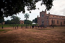
![Deim Zubeir[1] is located in South Sudan](http://upload.wikimedia.org/wikipedia/commons/thumb/2/28/South_Sudan_adm_location_map.svg/250px-South_Sudan_adm_location_map.svg.png)