Global Information Lookup Global Information

Dapani information


Dapani
Village
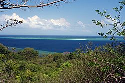
Saziley Point, east of Dapani
Dapani is located in Mayotte
Dapani
Dapani
Coordinates: 12°58′17″S 45°9′39″E / 12.97139°S 45.16083°E / -12.97139; 45.16083
CountryDapani France
Overseas TerritoryMayotte
CommuneBandrele
Area
 • Total3.646 km2 (1.408 sq mi)

Dapani is a village in the commune of Bandrele on Mayotte. It is located near the Pointes et plages de Saziley et Charifou protected area on the south-east of Mayotte. The protected area includes Dapani Beach and mangroves, and is a notable bird habitat known for its "botanical trail" through the mangroves.

Two locals on the beach in Dapani

and 4 Related for: Dapani information

Request time (Page generated in 0.5283 seconds.)

Dapani

Last Update:

Dapani is a village in the commune of Bandrele on Mayotte. It is located near the Pointes et plages de Saziley et Charifou protected area on the south-east...

Word Count : 74

Pointes et plages de Saziley et Charifou

Last Update:

digitata). The protected area also includes the beaches and mangroves of Dapani and Charifou west of Point Salizey. The adjacent sea is part of Mayotte...

Word Count : 250

Comoros forests

Last Update:

Dzialandzé, both Ramsar List sites. Saziley Point is visited from the village of Dapani on Mayotte, there is a birding trail through the forest. Moheli is the smallest...

Word Count : 1566

Communes of Mayotte

Last Update:

Bandrele 5,537 36.46 152 Bandrele 2,124 M'tsamoudou 1,395 Nyambadao 813 Dapani 568 Bambo Est 353 Hamouro 284 14 M'Tsangamouji 5,382 21.84 246 M'Tsangamouji...

Word Count : 170

PDF Search Engine © AllGlobal.net