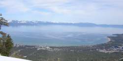
Lake Tahoe, headwater sub-basin of the Truckee River watershed
The DSSAM Model (Dynamic Stream Simulation and Assessment Model) is a computer simulation developed for the Truckee River to analyze water quality impacts from land use and wastewater management decisions in the Truckee River Basin. This area includes the cities of Reno and Sparks, Nevada as well as the Lake Tahoe Basin. The model is historically and alternatively called the Earth Metrics Truckee River Model. Since original development in 1984-1986 under contract to the U.S. Environmental Protection Agency (EPA),[1] the model has been refined and successive versions have been dubbed DSSAM II and DSSAM III. This hydrology transport model is based upon a pollutant loading metric called Total maximum daily load (TMDL). The success of this flagship model contributed to the Agency's broadened commitment to the use of the underlying TMDL protocol in its national policy for management of most river systems in the United States.[2]
The Truckee River has a length of over 115 miles (185 km) and drains an area of approximately 3120 square miles,[3] not counting the extent of its Lake Tahoe sub-basin. The DSSAM model establishes numerous stations along the entire river extent as well as a considerable number of monitoring points inside the Great Basin's Pyramid Lake, the receiving waters of this closed hydrological system. Although the region is sparsely populated, it is important because Lake Tahoe is visited by 20 million persons per annum and Truckee River water quality affects at least two endangered species: the Cui-ui sucker fish and the Lahontan cutthroat trout.
^C.M.Hogan, Marc Papineau et al. Development of a dynamic water quality simulation model for the Truckee River, Earth Metrics Inc., Environmental Protection Agency Technology Series, Washington D.C. (1987)
^Guidance for Water Quality-Based Decisions: The TMDL Process (Report). Washington, D.C.: U.S. Environmental Protection Agency (EPA). April 1991. EPA 440/4-91-001.
^John Warwick, Truckee River spill model, University of Nevada-Reno (2002).
The DSSAMModel (Dynamic Stream Simulation and Assessment Model) is a computer simulation developed for the Truckee River to analyze water quality impacts...
climate warmed.[citation needed] Recent computer simulations (using the DSSAMModel and other techniques) indicate, if precipitation and evaporation rates...
evolutionary algorithm to automated watershed model calibration. The United States EPA developed the DSSAMModel to analyze water quality impacts from land...
stream reaches. The DSSAMmodel was developed by the U.S. Environmental Protection Agency (EPA). This hydrology transport model is actually based upon...
analyzed by the United States Environmental Protection Agency using the DSSAMModel.[citation needed] U.S. Geological Survey Geographic Names Information...
as input parameters for hydrology transport models (such as the Storm Water Management Model or DSSAMModels) to allow prediction of river water quality...
risks for water-quality excursions. Other computer models have been developed (such as the DSSAMModel) that allow surface runoff to be tracked through...
Environmental Protection Agency, which funded the development of the DSSAMmodel to analyze water quality below Lake Tahoe. Lake Tahoe never freezes....
there are several such hydrology transport models such as the SWMM and DSSAMModels developed by the U.S. Environmental Protection Agency for river water...
was used to successfully restock Lake Lahontan. Winnemucca Lake Cui-ui DSSAMModel "National Register Information System". National Register of Historic...
model such as the USGS runoff precipitation algorithm, while the instream transport may be analyzed by a dynamic river pollutant model such as DSSAM....
dynamic hydrology transport model was developed by Earth Metrics Inc. The model's name was subsequently changed to DSSAM, and it was applied to analyze...
comprehensive dynamic hydrology transport model, the Dynamic Stream Simulation and Assessment Model (DSSAM), was applied to analyze impacts of a variety...
conducted on Pyramid Lake including the application of the DSSAM hydrological river model to examine nitrogen, reactive phosphorus, dissolved oxygen and...
will come under Directorate of Space Situational Awareness and Management (DSSAM) in Bengaluru. It will collect tracking data on inactive satellites and...
Nash–Sutcliffe model efficiency coefficient GLUE Hydrological transport model Canadian Land Surface Scheme CHyM – Cetemps Hydrological Model DRAINMOD[1] DSSAM FEHM...
will come under Directorate of Space Situational Awareness and Management (DSSAM) in Bengaluru. It will collect tracking data on inactive satellites and...
 Global Information