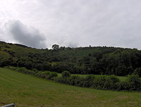
Crook Peak to Shute Shelve Hill is a 332.2 hectare (820.9 acre) geological and biological Site of Special Scientific Interest near the western end of the Mendip Hills, Somerset. The line of hills runs for approximately 5 kilometres (3.1 mi) from west to east and includes: Crook Peak, Compton Hill, Wavering Down, Cross Plain and Shute Shelve Hill. Most of the site is owned by the National Trust, which bought 725 acres (293 ha) in 1985,[1] and much of it has been designated as common land.[2] It was notified as an SSSI by Natural England in 1952.
The ecology of the area includes ancient woodland and calcareous grassland which supports nationally rare species including the Cheddar pink. The underlying rocks are Carboniferous Limestone containing phreatic caves at Shute Shelve Cavern and Picken's Hole from which fossils dating from the Middle Devensian have been recovered.
^"Trust fundraising push reached new heights". Western Daily Press. 9 September 2010. Archived from the original on 26 April 2015. Retrieved 26 April 2015.
^"Crooks Peak and Compton Bishop Hill". Common Land in England. Retrieved 26 April 2015.
and 21 Related for: Crook Peak to Shute Shelve Hill information
the Mendip Hills. The maximum depth of the gorge is 137 m (449 ft), with a near-vertical cliff-face to the south, and steep grassy slopes to the north...
up toCrookPeak and ShuteShelve, at the western edge of the Mendip Hills, and is part of the Wessex walk route leading from Weston-super-Mare to Wells...
The route here follows the northern boundary of the Crook Peak toShuteShelveHill SSSI. After descending through woodland, the route crosses the Samaritans...
ornithological importance due to colonisation by the Dartford warbler (Sylvia undata), which can be found at Black Down and CrookPeak. In Britain, this species...
Yatton, and in the opposite direction through the railway tunnel at ShuteShelveHillto Axbridge and Cheddar. The railway station was originally named Woodborough...
10,810 in 2019. Mendip District Council was based there. The Mendip Hills lie to the north and the River Sheppey runs through the town, as does the route...
broadcasting and telecommunications facility on the summit of Pen Hill, part of the Mendip Hills range in Somerset, England, at 305 metres (1,001 ft) above sea...
England, on the River Axe, near the southern edge of the Mendip Hills. Its population according to the 2011 census was 2,057. Axanbrycg is suggested as the source...
attraction in the village of Wookey Hole on the southern edge of the Mendip Hills near Wells in Somerset, England. The River Axe flows through the cave. It...
Limestone gorge near the village of Burrington, on the north side of the Mendip Hills Area of Outstanding Natural Beauty, in North Somerset, England. "Combe"...
and surrounding area, taking its supply from the Mendip Hills. Some of the lake water is used to maintain the flow in the River Chew. Before the lake was...
that flows for some 17 miles (27 km) through the North Somerset countryside to form the Chew Valley before merging with the River Avon. The spring from which...
Pen Hill forms part of the Mendip Hills plateau in Somerset, England. The hill is located in St Cuthbert Out civil parish in Mendip district. The name...
of the Mendip Hills, within the affluent Chew Valley in Somerset. It lies east of Chew Valley Lake and north east of the Mendip Hills, approximately...
south of Bath and Bristol on the A39 very close to the A37. The village is in a valley on the Mendip Hills and is the source of the River Chew. The parish...
a limestone quarry at East Cranmore, near Shepton Mallet on the Mendip Hills, Somerset, England. The quarry was formerly known as Merehead, a name which...
 Global Information