Administrative division of Yorkshire, England until 1974
For the settlement, see Leeds. For the current metropolitan administrative boundaries, see City of Leeds.
City of Leeds
County Borough of Leeds
Leeds Town Hall
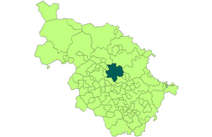
Leeds shown within the West Riding in 1971
Area
• 1911
21,593 acres (8,738 ha)
• 1931
38,105 acres (15,421 ha)
• 1961
40,612 acres (16,435 ha)
Population
• 1911
445,550
• 1931
482,809
• 1961
510,676
Density
• 1911
21/acre
• 1931
13/acre
• 1961
13/acre
History
• Origin
Leeds ancient borough[1]
• Created
1836
• Abolished
1974
• Succeeded by
City of Leeds (metropolitan district)
Status
Municipal borough (1835–1889) County borough (1889–1974) City (1893–1974)
Government
• HQ
Leeds
• Motto
PRO REGE ET LEGE
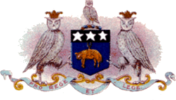
Coat of arms in use until 1921
The County Borough of Leeds, and its predecessor, the Municipal Borough of Leeds, was a local government district in the West Riding of Yorkshire, England, from 1835 to 1974.[2] Its origin was the ancient borough of Leeds, which was reformed by the Municipal Corporations Act 1835. In 1889, when West Riding County Council was formed, Leeds became a county borough outside the administrative county of the West Riding; and in 1893 the borough gained city status. The borough was extended a number of times, expanding from 21,593 acres (8,738 ha) in 1911 to 40,612 acres (16,435 ha) in 1961; adding in stages the former area of Roundhay, Seacroft, Shadwell and Middleton parishes and gaining other parts of adjacent districts. In 1971 Leeds was the fifth largest county borough by population in England. The county borough was abolished in 1974 and replaced with the larger City of Leeds, a metropolitan district of West Yorkshire.
^Great Britain Historical GIS / University of Portsmouth, Leeds ancient borough. Retrieved 16 September 2009. Archived 25 December 2012 at archive.today
^Great Britain Historical GIS / University of Portsmouth, Leeds MB/CB. Retrieved 16 September 2009.
and 17 Related for: County Borough of Leeds information
The CountyBoroughofLeeds, and its predecessor, the Municipal BoroughofLeeds, was a local government district in the West Riding of Yorkshire, England...
Leeds, also known as the City ofLeeds, is a metropolitan borough with city status in West Yorkshire, England. The metropolitan borough includes the administrative...
College was named. In 1893 the CountyBoroughofLeeds was granted city status, and in 1897 Queen Victoria conferred the title of Lord Mayor on James Kitson...
Act 1972, the area of the CountyBoroughofLeeds was combined with those of the Municipal Boroughof Morley, the Municipal Boroughof Pudsey, Aireborough...
market town in the City ofLeedsBorough in West Yorkshire, England. It is located midway between Bradford city centre and Leeds city centre. Historically...
identifiable areas. The metropolitan borough is divided into 33 wards, each of which elects three members ofLeeds City Council. The ward boundaries were...
The Coat of arms ofLeeds City Council derives its design from the seventeenth century. In 1662 the BoroughofLeeds received a new charter which created...
A total of 99 councillors have been elected from 33 electoral wards across Leeds since 1980. From 1889 until 1974 Leeds was a countyborough, independent...
which Leeds, Yorkshire derives its name, was anciently a forested area of the Celtic kingdom of Elmet. The settlement certainly existed at the time of the...
English ceremonial countyof West Yorkshire is divided into 22 parliamentary constituencies: 12 borough constituencies and 10 county constituencies. †Conservative...
boroughof Blackburn with Darwen, England Chapeltown, South Yorkshire, a suburb of Sheffield, South Yorkshire, England Chapeltown, Leeds, a suburb of...
Yorkshire and the boroughsof Bradford and Leeds in West Yorkshire. It fell primarily within the HG, LS and YO postcode areas, while a small part of it was within...
parish ofLeeds in West Yorkshire, England. It is 5 miles (8.0 km) north of central Leeds and is one of the most affluent areas of the county. Alwoodley...
 Global Information