Highland plateau in the north-central United States
This article needs additional citations for verification. Please help improve this article by adding citations to reliable sources. Unsourced material may be challenged and removed. Find sources: "Coteau des Prairies" – news · newspapers · books · scholar · JSTOR(July 2016) (Learn how and when to remove this message)
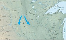
The Coteau des Prairies: blue arrows indicate paths of the two lobes of the glacier around either side of the formation.This excerpt from the Lewis and Clark map of 1814 shows the rivers of western Iowa and eastern South Dakota. The Coteau des Prairies is seen near the upper center of the map, "High land covered with wood called mountain of the prairie."
The Coteau des Prairies is a plateau approximately 200 miles in length and 100 miles in width (320 by 160 km), rising from the prairie flatlands in eastern South Dakota, southwestern Minnesota, and northwestern Iowa in the United States. The southeast portion of the Coteau comprises one of the distinct regions of Minnesota, known as Buffalo Ridge. The tip of the feature starts in extreme south North Dakota.
The flatiron-shaped plateau was named by early French explorers from New France (Quebec), coteau meaning "hill" in French; the general term coteau has since been used in English to describe any upland dividing ridge.[1]
The plateau is composed of thick glacial deposits, the remnants of many repeated glaciations, reaching a composite thickness of approximately 900 feet (275 m). They are underlain by a small ridge of resistant Cretaceous shale. During the last (Pleistocene) Ice Age, two lobes of the Laurentide glacier, the James lobe on the west and the Des Moines lobe on the east, appear to have parted around the pre-existing plateau and further deepened the lowlands flanking the plateau.
The plateau has numerous small glacial lakes and is drained by the Big Sioux River in South Dakota and the Cottonwood River in Minnesota. Pipestone deposits on the plateau have been quarried for hundreds of years by Native Americans, who use the prized, brownish-red mineral to make their sacred ceremonial pipes. The quarries are located at Pipestone National Monument in the southwest corner of Minnesota and in adjacent Minnehaha County, South Dakota.
Numerous wind farms have been built on the area's surface to take advantage of the high average wind speeds.[2][3]
^"entry for "coteau"". Oxford English Dictionary. Retrieved December 19, 2014.
^"2009 Wind Technologies Market Report" (PDF). Archived from the original (PDF) on March 1, 2012. Retrieved July 5, 2013.
^"U.S. 80 Meter Wind Resource Map". Windpoweringamerica.gov. Archived from the original on July 28, 2013. Retrieved July 5, 2013.
and 23 Related for: Coteau des Prairies information
The CoteaudesPrairies is a plateau approximately 200 miles in length and 100 miles in width (320 by 160 km), rising from the prairie flatlands in eastern...
separating the plateau from the CoteaudesPrairies substantially. This specific area is also attached to the Canadian Prairies, with forests and elevated...
rises in Roberts County, South Dakota on a low plateau known as the CoteaudesPrairies and flows generally southwardly through Grant, Codington, Hamlin...
County, approximately six miles (9.7 km) southwest of Ivanhoe, on the CoteaudesPrairies, a morainic plateau dividing the Mississippi and Missouri River watersheds...
of this area include the CoteaudesPrairies, the Dissected Till Plains, and the James River Valley. The CoteaudesPrairies is a higher region bordered...
through northwestern Lincoln County as an intermittent stream on the CoteaudesPrairies, a morainic plateau dividing the Mississippi and Missouri River watersheds...
Paläontologie, Teil I. 11/12: 1635–46. ISSN 0340-5109. Verhandlungsblatt des Südamerika-Symposiums 1984 in Bamberg. Kuhle, M. (1986). "Die Vergletscherung...
Indiana Southwestern Indiana Wabash Valley Regions of Iowa include: CoteaudesPrairiesDes Moines metropolitan area Dissected Till Plains Driftless Area Great...
Agassiz while outlets to the north were blocked by glaciers. The CoteaudesPrairies divides the Minnesota and Missouri River valleys, and is a striking...
southwestern Minnesota and southeastern Dakota ... between Swan Lake and CoteaudesPrairies," until forced to move to reservation land near the Minnesota River...
Politics Regions Badlands Black Hills CoteaudesPrairies Missouri Coteau Dissected Till Plains Drift Prairie East River Pine Ridge Siouxland West River...
United States Chippewa Moraine State Recreation Area, Wisconsin CoteaudesPrairies, South Dakota Devil's Lake State Park, Wisconsin Glacial Lake Wisconsin...
populous city, and largest metropolitan area fully located within the state is Des Moines. A portion of the larger Omaha, Nebraska, metropolitan area extends...
Valley (Tallgrass Aspen Parkland) in Manitoba and Minnesota; the CoteaudesPrairies, which extends from South Dakota through Minnesota and into Iowa;...
The heaviest winds in the state are found on the Buffalo Ridge, or CoteaudesPrairies, a flatiron-shaped area extending from Watertown, South Dakota, diagonally...
replanting keep about a third of the state forested. Nearly all Minnesota's prairies and oak savannas have been fragmented by farming, grazing, logging, and...
County, approximately four miles (6.4 km) west of Ruthton, on the CoteaudesPrairies, a morainic plateau dividing the Mississippi and Missouri River watersheds...
United States Chippewa Moraine State Recreation Area, Wisconsin CoteaudesPrairies, South Dakota Devil's Lake State Park, Wisconsin Glacial Lake Wisconsin...
protected valleys and on north-facing slopes, wet prairies along the rivers, and some mesic prairie on the floodplain farther back from the river.[citation...
 Global Information