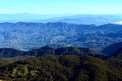
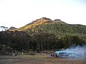
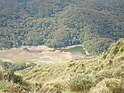
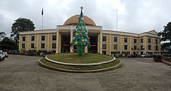
(from top: left to right) Mount Apo Rainforest, Paniki Falls in Kidapawan, Lake Venado Campsite, Lake Venado, Provincial road in Carmen and Kidapawan City Hall.
September 1, 1914 (founded as the Empire Province of Cotabato)
November 22, 1973 (Maguindanao and Sultan Kudarat were carved out)
Capital and largest city
Kidapawan
Government
• Governor
Emmylou Taliño-Mendoza (NP)
• Vice Governor
Efren F. Piñol (PDP–Laban)
• Legislature
Cotabato Provincial Board
Area
[1]
• Total
9,008.90 km2 (3,478.36 sq mi)
• Rank
6th out of 81
Highest elevation
(Mount Apo)
2,954 m (9,692 ft)
Population
(2020 census)[2]
• Total
1,275,185
• Rank
22nd out of 81
• Density
140/km2 (370/sq mi)
• Rank
57th out of 81
Divisions
• Independent cities
0
• Component cities
1
Kidapawan
• Municipalities
25
Alamada
Aleosan
Antipas
Arakan
Banisilan
Carmen
Kabacan
Kadayangan
Kapalawan
Libungan
Ligawasan
M'lang
Magpet
Makilala
Malidegao
Matalam
Midsayap
Nabalawag
Old Kaabakan
Pahamuddin
Pigcawayan
Pikit
President Roxas
Tugunan
Tulunan
• Barangays
606
• Districts
Legislative districts of Cotabato
Time zone
UTC+8 (PST)
ZIP code
9400–9417
IDD: area code
+63 (0)64
ISO 3166 code
PH-NCO
Spoken languages
Hiligaynon
Maguindanaon
Cebuano
Chavacano
Iranun
Dulangan Manobo
Obo
Tagabawa
Tboli
Ilianen
Tagalog
English
Income classification
1st class
Website
cotabatoprov.gov.ph
* excluding 8 municipalities under BARMM
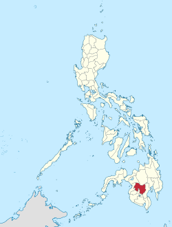
Cotabato or North Cotabato (Hiligaynon: Aminhan Cotabato; Maguindanaon: Utara Kutawatu, Jawi: اوتار كوتوات; Cebuano: Amihanang Cotabato; Filipino: Hilagang Cotabato), officially the Province of Cotabato, is a landlocked province in the Philippines located in the Soccsksargen region in Mindanao. Its capital is the city of Kidapawan. Some of its municipalities are under the jurisdiction of the nearby Bangsamoro Autonomous Region.
^"List of Provinces". PSGC Interactive. Makati, Philippines: National Statistical Coordination Board. Archived from the original on January 17, 2013. Retrieved June 3, 2014.
^Census of Population (2020). "Region XII (Soccsksargen)". Total Population by Province, City, Municipality and Barangay. Philippine Statistics Authority. Retrieved July 8, 2021.
Cotabato City, officially the City of Cotabato (Maguindanaon: Kuta nu Kutawatu, Jawi: كوت نو كوتوات; Cebuano: Dakbayan sa Cotabato; Filipino: Lungsod...
(South Cotabato, Cotabato, Sultan Kudarat, Sarangani and General Santos). The regional center is in Koronadal, located in the province of South Cotabato, and...
Cotabato Airport (IATA: CBO, ICAO: RPMC), also known as Awang Airport, is an airport serving the general area of Cotabato City, North Cotabato, Maguindanao...
Kidapawan), is a 3rd class component city and capital of the province of Cotabato, Philippines. According to the 2020 Census, it has a population of 160...
Soccsksargen region, and is geographically located within the province of South Cotabato but administered independently of it. The city was named after Gen. Paulino...
Cotabato Manobo (Dulangan Manobo) is a Manobo language spoken in Mindanao, the Philippines. Dialects include Tasaday and Blit. Cotabato Manobo is spoken...
Tagalog: Bayan ng Midsayap), is a 1st class municipality in the Province of Cotabato, Philippines. According to the 2020 census, it has a population of 117...
backed by Filipino and Malaysian businesspeople. The airline which has Cotabato Airport in Datu Odin Sinsuat, Maguindanao del Norte as its hub, is meant...
South Cotabato, Philippines. According to the 2020 census, it has a population of 195,398 people. It is the capital of the province of South Cotabato and...
Norte and Cotabato regarding their cession to the Bangsamoro region. As a result of the second part of the plebiscite, 63 barangays of Cotabato province...
Cotabato Spikers are a men's volleyball team based in North Cotabato which plays in the Spikers' Turf, a league in the Philippines. The AMC Cotabato Spikers...
is a chain of shopping malls that originated in Koronadal City, South Cotabato, Philippines. It is owned by Koronadal Commercial Corporation and its headquarters...
South Cotabato and Davao del Sur to the north, Davao Occidental to the east, and the Celebes Sea to the south. Sarangani is part of the South Cotabato-Cotabato-Sultan...
Retrieved 23 March 2010. Unson, John (16 February 2000). "Death toll in Cotabato store bomb explosion reaches 3". Philstar. Archived from the original on...
Santos (pop. 697,315), Butuan (pop. 372,910), Iligan (pop. 363,115) and Cotabato City (pop. 325,079). About 70% of residents identify as Christian and 24%...
The Cotabato Regional and Medical Center (CRMC) is a government-owned hospital situated in Cotabato City which serves both the main land Bangsamoro region...
province of Cotabato in the Philippines. It is part of the Bangsamoro Autonomous Region in Muslim Mindanao, despite the province of Cotabato itself being...
ايڠد نو ڤولومولوک), is a 1st class municipality in the province of South Cotabato, Philippines. As of May 2020, it has a population of 172,605 people making...
The Grand Mosque of Cotabato, officially the Sultan Haji Hassanal Bolkiah Mosque, is situated in Cotabato City and is the second largest mosque in the...
Davao, and General Santos, and the provinces of North Cotabato, Sultan Kudarat, South Cotabato, Sarangani, Zamboanga del Sur, Zamboanga Sibugay, Davao...
Tagalog: Bayan ng Kabacan), is a 1st class municipality in the province of Cotabato, Philippines. According to the 2020 census, it has a population of 77,164...
Tagalog: Bayan ng Pigkawayan), is a 1st class municipality in the province of Cotabato, Philippines. According to the 2020 census, it has a population of 52,744...
 Global Information