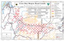
The Coos Bay Wagon Road or Coos Bay Military Wagon Road was a pioneer road in the U.S. state of Oregon that connected Douglas County to Coos Bay starting in 1872.[1] Travelers on the road could start in either Tenmile or Lookingglass near Roseburg. The route passed through Reston, Sitkum, Dora, McKinley, and Fairview, ending in Sumner south of Coos Bay. Eventually the road was continued to Eastside, now a neighborhood of Coos Bay.[2] The road follows the East Fork Coquille River from near the Coos/Douglas county line to Dora.[3]
^Guyer, R.J. (October 3, 2012). "Past echoes on Coos Bay Wagon Road". The News-Review. Retrieved February 23, 2012.
^McArthur, Lewis A.; McArthur, Lewis L. (2003) [1928]. Oregon Geographic Names (7th ed.). Portland, Oregon: Oregon Historical Society Press. p. 314. ISBN 978-0875952772.
^Oregon Atlas & Gazetteer (7th ed.). Yarmouth, Maine: DeLorme. 2008. pp. 52–53. ISBN 0-89933-347-8.
and 19 Related for: Coos Bay Wagon Road information
approximately 73,583 acres of land in Coos and Douglas counties that had been conveyed by the United States to the CoosBayWagonRoad. Congress enacted the Oregon...
monuments, Indian reservations, railroad grant lands, and revested CoosBayWagonRoad grant lands. Surrounding land owners may be granted right of passage...
the Interior to harvest timber from the O&C lands (as well as the CoosBayWagonRoad Lands) on a sustained yield basis. The legislation returned 50 percent...
1926 1937: Congress passes the Oregon and California Railroad and CoosBayWagonRoad Grant Lands Act of 1937 (O&C Act), which further modifies the terms...
Cascade Mountain Military WagonRoad from Albany to Fort Boise (1866), and the CoosBay Military WagonRoad from Roseburg to CoosBay (1869). The Dalles –...
southern Coos County, mostly in and to the southeast of the CoosBay-North Bend urban area. Parts of the communities of Bandon, Barview, CoosBay, and North...
Location in United States Show map of the United States Location 1191 CoosBayWagonRoad Lookingglass, Oregon Coordinates 43°10′43″N 123°30′21″W / 43.17861°N...
the construction of a wagonroad from Corvallis to Yaquina Bay, costing approximately $20,000 and spanning 45 miles. The road was completed in 1873 and...
Missouri April 22, 1940 Covered Wagon Days May 10, 1940 Gaucho Serenade distribution only May 10, 1940 The Crooked Road May 19, 1940 Gangs of Chicago May...
Bay Coal Company and reorganized it as a subsidiary, operating its mines until closing them in 1878. In the 1870s, the company purchased land in Coos...
suspension components, are shared with the R170 platform. For example, the engine bay of the Crossfire is virtually identical to the Mercedes-Benz SLK320 on the...
smaller profile, make the XJ better both off-road and on." AMC's initial forecasts of 40,000 Cherokee and Wagoneer sales were shattered, with sales amounting...
Reedsport, and CoosBay. This latter line closed at that time, but was sold in 2009 to the Port of CoosBay, which reopened it in 2011–2013 as CoosBay Rail Link...
timeline of the San Francisco Bay Area in California, events in the nine counties that border on the San Francisco Bay, and the bay itself. An identical list...
Yaquina Bay, like CoosBay, is a shallow coastal bay on the Oregon Coast in the Pacific Northwest of North America. The principal town on Yaquina Bay is Newport...
defunct IDA Indonesia Air Transport INTRA Indonesia QZ AWQ Indonesia AirAsia WAGON AIR Indonesia IO IAA Indonesian Airlines INDO LINES Indonesia IPN Industri...
Bullock teams hauling goods had to tie large logs to the back of their wagons to retard the speed of descent. The Government regularly sent work crews...
locomotives and 7231 wagons. R4Bn would be spent on infrastructure connecting Majuba coal-fired power station with the Richards Bay freight railway. Transnet...
 Global Information