Knik River, Little Susitna River, Susitna River, Matanuska River
Max. length
180 miles (290 km)
Surface area
100,000 km2 (39,000 sq mi)
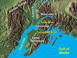
Cook Inlet (Tanaina: Tikahtnu; Sugpiaq: Cungaaciq) stretches 180 miles (290 km) from the Gulf of Alaska to Anchorage in south-central Alaska.[1] Cook Inlet branches into the Knik Arm and Turnagain Arm at its northern end, almost surrounding Anchorage. On its southern end, it merges with Shelikof Strait, Stevenson Entrance, Kennedy Entrance and Chugach Passage.[2]
The Cook Inlet and both its arms are bodies of brackish water, containing a turbid mix of ocean salt-water and freshwater runoff from the various rivers and streams. The narrow channel of the inlet funnels the tides creating very fast-moving currents, rip tides, and occasional bore tides.[3] Cook Inlet watershed is the most populated watershed in Alaska. The watershed covers about 100,000 km2 (39,000 sq mi) of southern Alaska, east of the Aleutian Range, south and east of the Alaska Range, receiving water from its tributaries, which include the Knik River, the Little Susitna River, the Susitna and Matanuska rivers, Eagle River, Ship Creek, Resurrection Creek, Portage Creek, Kenai River, and many others. The watershed includes the drainage areas of Denali (formerly named Mount McKinley) and is the collection point for the runoff from many surrounding glaciers, leading to the high turbidity and large silt deposits. Within the watershed there are several national parks and the active volcano Mount Redoubt, along with three other historically active volcanoes.[4] Cook Inlet provides navigable access to the port of Anchorage at the northern end, and to the smaller Homer port further south. Before the growth of Anchorage, Knik was the destination for most marine traffic in upper Cook Inlet. Approximately 400,000 people live within the Cook Inlet watershed.
^"Cook Inlet, Alaska". Archived from the original on June 11, 2007. Retrieved 2007-02-03.
^United States Coast Pilot 9. "Coast Pilot 9 – 33rd Edition, 2015". Office of Coast Survey. page 182. Retrieved 28 November 2015.{{cite web}}: CS1 maint: numeric names: authors list (link)
^Summary of Quaternary geology of the Municipality of Anchorage, Alaska
^"Cook Inlet-South Central Alaska map and volcano list". Alaska Volcano Observatory. Retrieved 2007-02-03.
CookInlet (Tanaina: Tikahtnu; Sugpiaq: Cungaaciq) stretches 180 miles (290 km) from the Gulf of Alaska to Anchorage in south-central Alaska. Cook Inlet...
Red List in 2008 as being "near threatened"; the subpopulation from the CookInlet in Alaska, however, is considered critically endangered and is under the...
The CookInlet Basin is a northeast-trending collisional forearc basin that stretches from the Gulf of Alaska into South central Alaska, just east of the...
USS CookInlet (AVP-36) was a United States Navy Barnegat-class small seaplane tender in commission from 1944 to 1946. She tended seaplanes during World...
contamination from the animal's strong castor (musk) gland. It is usually slow-cooked in a broth, and was a valuable food source to Native Americans.[citation...
contributions, including the Cook Islands, Cook Strait, CookInlet and the Cook crater on the Moon. Aoraki / Mount Cook, the highest summit in New Zealand...
1988 Athletes in Action Fire 2001–2011 Valley Green Giants 1976–1979 CookInlet Bucs 1980–1983 Alaska Goldpanners 1974–2010; 2012–2015 2023: Anchorage...
The CookInlet taiga is a taiga and boreal forests ecoregion in Alaska. This ecoregion is located around the upper CookInlet on the south-central coast...
volume at its mouth. The river stretches from the Susitna Glacier to CookInlet's Knik Arm. The Susitna River was named by the Dena'ina Alaska Native people...
landmark in the Anchorage area and can be seen across the Knik Arm of the CookInlet from most of the city, especially at higher elevations. The mountain's...
south of Anchorage. It is separated from the mainland on the west by CookInlet and on the east by Prince William Sound. Most of the peninsula is part...
Alaska, at the north end of the Alaska Peninsula, between Kvichak Bay and CookInlet, about 100 miles (160 km) west of Seldovia, Alaska. It shares a name with...
preserve year-round. The park protects rainforests along the coastline of CookInlet, alpine tundra, glaciers, glacial lakes, major salmon-bearing rivers,...
in Lake Clark National Park and Preserve, the mountain is just west of CookInlet, in the Kenai Peninsula Borough about 110 miles (180 km) southwest of...
Near its mouth, it flows through Captain Cook State Recreation Area and under Kenai North Road to enter CookInlet. Swanson River and the many lakes around...
The CookInlet Aquaculture Association (CIAA) is a non-profit organization based in Kenai, Alaska, that works to create sustainable salmon stocks in the...
Missouri CookInlet, off the Gulf of Alaska Cook, South Australia Cook County, New South Wales Cook, Australian Capital Territory Division of Cook, an Australian...
climbers. The party navigated up the Cookinlet and followed the path of the 1902 Brooks party towards Denali. Cook approached the mountain via the Peters...
the quieter effusion of lava. It forms Augustine Island in southwestern CookInlet in the Kenai Peninsula Borough of southcentral coastal Alaska, 174 miles...
 Global Information