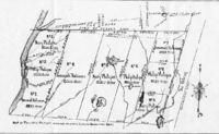
Connecticut panhandle and "The Oblong"A 1799 map of Connecticut which shows The Oblong. From Low's EncyclopaediaMap of Philipse Patent (showing the Oblong and Gore)
The Connecticut panhandle is the southwestern appendage of Connecticut, where it abuts New York State. It is contained entirely in Fairfield County and the Western Connecticut Planning Region, and includes all of Greenwich, Stamford, New Canaan, and Darien,[1] as well as parts of Norwalk and Wilton. It has some of the most expensive residential real estate in the United States.
The irregularity in the boundary is the result of territorial disputes in the late 17th century between the British colonies of New York and Connecticut. In an agreement on November 28, 1683, that established the New York–Connecticut border as 20 miles (32 km) east of the Hudson River, New York gave up its claim to this area of 61,660 acres (249.5 km2) east of the Byram River, whose residents considered themselves part of Connecticut. In exchange, New York received an equivalent area consisting of a 1.81-mile-wide (2.91 km) strip of land known as the "Oblong" running northwards from Ridgefield, Connecticut to the Massachusetts border, alongside the New York counties of Westchester, Putnam, and Dutchess. New York was also given undisputed claim to Rye, New York.[2][3][4][5][6]
^
Frank R. Abate (2001). Connecticut Trivia. Thomas Nelson Inc. p. 19. ISBN 9781558539259.
^
Mark Stein (2008). How the States Got Their Shapes. HarperCollins. pp. 198–199. ISBN 9780061431395.
^"Surveying Connecticut's Borders | ConnecticutHistory.org". connecticuthistory.org. Retrieved July 19, 2018.
^"CT-NY-MA Tri-Point". www.ctmq.org. Retrieved July 19, 2018.
^"The Oblong in Pawling: A History of a Quaker Hill Community in the Hudson Valley". Retrieved July 19, 2018.
^"About Town: The Oblong | The Ridgefield Press". The Ridgefield Press. September 6, 2016. Archived from the original on July 19, 2018. Retrieved July 19, 2018.
and 17 Related for: Connecticut panhandle information
The Connecticutpanhandle is the southwestern appendage of Connecticut, where it abuts New York State. It is contained entirely in Fairfield County and...
"Connecticut's Southwick Jog". Connecticut State Library. Archived from the original on October 24, 2010. "Connecticut's "Panhandle"". Connecticut State...
Southeastern Connecticut Western Connecticut Some of Connecticut's informal regions include: Coastal ConnecticutConnecticutpanhandle/Gold Coast Farmington Valley...
as a panhandle or bootheel, is an elongated protrusion of one jurisdiction into another. Alaska PanhandleConnecticutpanhandle Florida Panhandle Idaho...
land on the New York-Connecticut border in the United States nicknamed the "Oblong", running north from the Connecticutpanhandle Oblong (company), an...
state of Connecticut has adopted numerous symbols, which are found in Chapter 33, Sections 3.105–110 of the General Statutes of Connecticut, and are listed...
(249.5 km2) east of the Byram River making up the ConnecticutPanhandle were granted to Connecticut. In exchange, Rye was granted to New York, along with...
The U.S. State of Connecticut currently has nine statistical areas that have been delineated by the Office of Management and Budget (OMB). On July 21...
Northeastern Connecticut, better known as the Quiet Corner, is a historic region of the state of Connecticut, located in the northeastern corner of the...
Connecticut is a state of the United States in the New England region. Following the Chicago Symphony, Boston Symphony and the New York Philharmonic,...
Ridgefield in Connecticut as possible, as well as settled on the "equivalent land" that New York would receive in exchange for the Connecticutpanhandle (i.e....
is a residential neighborhood in the city of Norwalk, Connecticut in the ConnecticutPanhandle region of Fairfield County. It lies in the western central...
electricity-generating power stations in the U.S. state of Connecticut, sorted by type and name. In 2022, Connecticut had a total summer capacity of 10,108 MW through...
parks, reserves, forests and wildlife management areas (WMAs) in the Connecticut state park and forest system, shown in five tables. The first table lists...
split in half. The southwestern border of Connecticut where it abuts New York State is marked by a panhandle in Fairfield County, containing the towns...
Hawaii - Hawai'i Gas Kansas – Aquila, Inc. Atmos Energy Kansas Gas Service Panhandle Eastern Pipe Line Xcel Energy Black Hills Energy Kentucky – Atmos Energy...
prohibition of aggressive panhandling and regulation of passive panhandling is controlled by individual cities, with many panhandlers being charged with loitering...
 Global Information