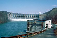
Conemaugh Dam (also known as Conemaugh River Dam or Conemaugh River Lake Dam) is a concrete gravity dam across the Conemaugh River, near the town of Saltsburg, in Pennsylvania. The dam was authorized by the Flood Control Act of 1936 and completed in 1952 by the U.S. Army Corps of Engineers for flood protection on the Conemaugh, Kiskiminetas, and Allegheny Rivers. The dam is one of 16 flood control structures in the Corps' Pittsburgh District.[2]
With a capacity of 355,000 acre-feet (438,000 dam3), the lake is usually kept at a much lower level of 5,140 acre-feet (6,340 dam3), to accommodate flash floods.[1] Water is released as quickly as possible while not exacerbating flooding conditions downstream. The dam has prevented a total of $2.2 billion of flooding-related damages between 1952 and 2013, including $375 million during 2004's Hurricane Ivan alone.[2] The dam also supplies water to a 14 MW hydroelectric power station which was commissioned in 1989.[3]
Conemaugh Lake Recreation Area is located adjacent to the dam and preserves several historic sites, including segments of the Main Line Canal that once connected Pittsburgh to Philadelphia.[4][5]
^ abcde"Archived copy". Archived from the original on 2014-03-05. Retrieved 2014-03-01.{{cite web}}: CS1 maint: archived copy as title (link)
^ ab"Pittsburgh District > Missions > Recreation > Lakes > Conemaugh River Lake".
^"Hydroelectric Plants in Pennsylvania". IndustCards. Retrieved 3 March 2014.
^"Archived copy". Archived from the original on 2014-03-05. Retrieved 2014-03-01.{{cite web}}: CS1 maint: archived copy as title (link)
ConemaughDam (also known as Conemaugh River Dam or Conemaugh River Lake Dam) is a concrete gravity dam across the Conemaugh River, near the town of Saltsburg...
South Fork Dam was an earthenwork dam forming Lake Conemaugh (formerly Western Reservoir, also known as the Old Reservoir and Three Mile Dam, a misnomer)...
The Conemaugh River is a 70-mile (110 km) tributary of the Kiskiminetas River in Westmoreland, Indiana, and Cambria counties in the U.S. state of Pennsylvania...
after the catastrophic failure of the South Fork Dam, located on the south fork of the Little Conemaugh River, 14 miles (23 km) upstream of the town of...
Station Dam, NDS ID Number PA-661 Susquehanna River Basin, Davis Run, Schuylkill County Charleroi Locks & Dam, Monongahela River, USACE ConemaughDam, Conemaugh...
the ConemaughDam Marburg, under Lake Marburg. Milford Mills, flooded by creation of Marsh Creek Lake Social Hall, under the waters of Conemaugh River...
rainfall of July 19–20, 1977, six dams failed in the Conemaugh Valley. The Laurel Run Dam on Laurel Run was an old earthen dam originally owned by the Bethlehem...
The Little Conemaugh River is a tributary of the Conemaugh River, approximately 30 miles (48 km) long, in western Pennsylvania in the United States. The...
to locals as The Dam, is created by the Quemahoning Dam, located on Quemahoning Creek on the border of Quemahoning Township, Conemaugh Township, and Jenner...
The dam had not failed completely since 1862. Notwithstanding leaks and other warning signs, the flawed dam held the waters of Lake Conemaugh back until...
"Pennsylvania Railroad, Bow Ridge Tunnel, Through Bow Ridge, 0.3 mile South of ConemaughDam, New Alexandria, Westmoreland County, PA". Library of Congress. "Panoramio...
States Geological Survey, United States Department of the Interior. "Kinzua Dam". Geographic Names Information System. United States Geological Survey, United...
the ConemaughDam broke and flooded the surrounding valley. Damage was extraordinary, and the dam was never rebuilt. Also known as the Conemaugh Calamity...
about the South Fork Dam, which formed Lake Conemaugh above Johnstown and Cambria Iron Company's facilities. To monitor the dam, Morrell joined South...
construction of the ConemaughDam, PA 982 used to occupy Livermore Road, across from its current terminus, and continued on, crossing the Conemaugh River at Livermore...
Johnstown Flood occurred on May 31, 1889, when the South Fork Dam located on the Little Conemaugh River upstream of the town of Johnstown, Pennsylvania, failed...
narrow river valleys. In 1836, the South Fork dam was built to create a reservoir (later named Conemaugh Lake) for the Pennsylvania Canal's western division...
www.eia.gov. Retrieved 12 February 2020. "Electricity Data Browser - Conemaugh". www.eia.gov. Retrieved 9 February 2020. "Electricity Data Browser -...
This is a complete list of bridges and dams that span the Kiskiminetas River from its confluence at the Conemaugh River and Loyalhanna Creek to its mouth...
world's largest earthen dam, behind which formed a private lake called Lake Conemaugh. Less than 20 miles (32 km) downstream from the dam sat the city of Johnstown...
flows NNW, passing through Loyalhanna Lake reservoir and joins with the Conemaugh River to form the Kiskiminetas River at Saltsburg. The creek lies about...
accumulated snow on the ground, and the soil became saturated. By March 17, the Conemaugh River reached flood stage and was continuing to rise at the rate of 18...
 Global Information