 Global Information
Colemanville Covered Bridge information
Colemanville Covered Bridge | |
|---|---|
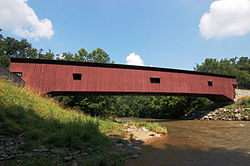 Wide view of the side of the bridge | |
| Coordinates | 39°53′56″N 76°20′32″W / 39.89889°N 76.34222°W |
| Carries | T412 / T398 |
| Crosses | Pequea Creek |
| Locale | Lancaster, Pennsylvania, United States |
| Official name | Pequea #12 Bridge |
| Other name(s) | Martic Forge |
| Maintained by | Lancaster County |
| NBI Number | 367224040815120 |
| Characteristics | |
| Total length | 170 ft (52 m) |
| Width | 15 ft (4.6 m) |
| Height | 11.5 ft (3.5 m) |
| Load limit | 11 t (12 short tons) |
| History | |
| Constructed by | James C. Carpenter |
| Built | 1856 |
U.S. National Register of Historic Places | |
| MPS | Covered Bridges of Lancaster County TR |
| NRHP reference No. | 80003534 |
| Added to NRHP | December 11, 1980 |
| Location | |
 | |
The Colemanville Covered Bridge is a covered bridge that spans Pequea Creek in Lancaster County, Pennsylvania, United States. After Hunsecker's Mill Covered Bridge, it is Lancaster County's second-longest single-span covered bridge still being used.[1] It is also referred to as the Martic Forge Covered Bridge and Pequea #12 Bridge.
The bridge has a single span, wooden, double Burr arch trusses design with the addition of steel hanger rods. The deck is made from oak planks.[2] It is painted red, the traditional color of Lancaster County covered bridges, on both the inside and outside. Both approaches to the bridge are painted red with white trim.
The bridge's WGCB Number is 38-36-26.[3] In 1980 it was added to the National Register of Historic Places as structure number 80003534.[4] The bridge is located on Fox Hollow Road just south of Pennsylvania route 324 in Martic Township, Pennsylvania.[1] It is located at 39°53′56.01″N 76°20′31.90″W / 39.8988917°N 76.3421944°W (39.898892, -76.342194).
- ^ a b "Colemanville Covered Bridge". Lancaster County Pennsylvania Dutch Country Official Visitors Center. Pennsylvania Dutch Convention & Visitors Bureau. 2006. Archived from the original on 2006-03-17. Retrieved 2006-07-07.
- ^ "Colemanville Covered Bridge". Lancaster County, PA Government Portal. County of Lancaster, Pennsylvania. 2001-10-20. Archived from the original on 2006-10-06. Retrieved 2006-07-07.
- ^ Dr. Roger A. McCain. "Colemanville Bridge". A Guide to Old Covered Bridges of Southeastern Pennsylvania and nearby areas. Archived from the original on 2006-09-07. Retrieved 2006-08-03.
- ^ "PENNSYLVANIA - Lancaster County". National Register of Historic Places. Retrieved 2007-03-20.