Coat of arms of the London Borough of Bexley information
Coat of arms
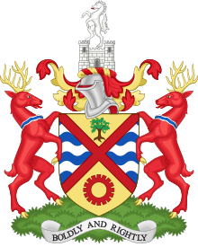
Coat of arms of the London Borough of Bexley is the official coat of arms of the London Borough of Bexley, granted on 20 May 1965.
The arms have wavy lines representing the rivers Thames, Cray and Shuttle, on which Bexley is situated. The gold fields at top with the oak tree and bottom with the cog wheel represent the agricultural and mineral wealth of the Borough. The oak tree was taken from the arms of the former Bexley council, and also signified the rural nature of much of the council's area. The red saltire has no official meaning, but it can be noted that there is also a red saltire in the arms of the Diocese of Rochester, to which the majority of Bexley belongs.
The horse in the crest is the white horse of Kent, a traditional symbol of the county. This horse was also present in the crest of the former Municipal Borough of Bexley and the arms of the Crayford UDC. Standing on a gateway, the horse symbolises the borough's location in the historic county of Kent.
The supporters are red stags, from the arms of Lord Eardley of Belvedere House. A stag like this was part of the crest of the former Municipal Borough of Erith. The stags are gorged with silver and blue waves from the shield in the Bexley arms to differentiate them.
The motto is a translation of the Latin motto 'FORTITER ET RECTE', which is the motto of Crayford[1][2]
^"Bexley - Heraldry of the World". Ngw.nl. Retrieved 2013-11-25.
^"Civic Heraldry Of England And Wales-Kent (Obsolete)". Civicheraldry.co.uk. Retrieved 2013-11-25.
and 29 Related for: Coat of arms of the London Borough of Bexley information
Bexley is an area of south-eastern Greater London, England and part oftheLondonBoroughofBexley. It is sometimes known as Bexley Village or Old Bexley...
before theborough's abolition in 1965, Labour took control. A coatofarms was granted to theBexley UDC on 16 October 1937 and inherited by theborough. The...
streets; the term was coined in 1902 by borough surveyor Charles Jones. This is reflected by the tree emblem on its council logo and its coatofarms. Within...
TheLondonBoroughof Richmond upon Thames (pronunciation) in southwest London, England, forms part of Outer London and is the only Londonborough on both...
Great Trees ofLondon is a list created by Trees for Cities after the Great Storm of 1987, when the general public were asked to suggest suitable trees...
now ruined, in Abbey Wood, in theLondonBoroughofBexley, southeast London, England. It is a scheduled monument, and the abbey's ruins are listed at Grade...
This is a list of notable people who were born or grew up in theLondonBoroughofBexley or otherwise have a strong association with the area. George Albert...
The Royal Boroughof Kingston upon Thames is a borough in southwest London. The main town is Kingston upon Thames and it includes Chessington, Malden...
covered much ofthe north-western and northern East End ofLondon. An individual coatofarms was never granted to the metropolitan borough council; they...
Lewisham constituency. Theborough contains the constituencies of: Eltham Erith and Thamesmead (shared with theLondonBoroughofBexley) Greenwich and Woolwich...
Theborough shares borders with theLondonBoroughsof Lewisham and Greenwich to the north, Bexley to the north-east, Southwark and Lambeth to the north-west...
Town. Theborough borders theLondonBoroughof Lambeth to the east, theLondonBoroughof Merton and the Royal Boroughof Kingston upon Thames to the south...
The Metropolitan Boroughof Chelsea was a metropolitan boroughofthe County ofLondon between 1900 and 1965. It was created by theLondon Government Act...
London, England, within theLondonBoroughofBexley. It lies east of Bexleyheath and north west of Dartford. Crayford was in the historic county of Kent...
Bexleyheath is a town in south-east London, England, in theLondonBoroughofBexley. It had a population of 15,600 (rounded to the nearest 100) in 2021 and is...
in theLondonBoroughofBexley in south-east London, built in 1537 for Sir John Champneys, a wealthy merchant and former Lord Mayor ofLondon. The house...
TheLondonBoroughof Redbridge is a Londonborough established in 1965. Theborough shares boundaries with the Epping Forest District and the ceremonial...
TheLondonBoroughof Haringey (/ˈhærɪŋɡeɪ/ HARR-ing-gay, same as Harringay) is a Londonborough in north London, classified by some definitions as part...
part oftheLondonBoroughofBexley. It lies north-east of Bexleyheath and north-west of Dartford, on the south bank ofthe River Thames. The town centre...
 Global Information