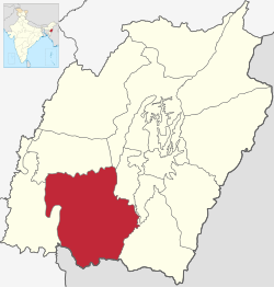
Churachandpur District[1] (Meitei pronunciation: /tʃʊraːˌtʃaːnɗpʊr/), is one of the 16 districts of the Indian state of Manipur populated mainly by Kuki-Zo people.[6] The name honours former Maharaja Sir Churachand Singh of Manipur.[7][8] The district headquarters is located in the Churachandpur town, which is also locally known by the name Lamka.[9]
The Churachandpur district first came into being as the South-West Area hill subdivision of Manipur in 1919.[10] It soon acquired the name "Churachandpur subdivision" based on its headquarters at Songpi, which was also called "Churachandpur". After the independence of India, it remained one of the eight subdivisions of Manipur.[11] A "New Churachandpur" town was built at the present location to serve as its headquarters. In 1969, the subdivision was upgraded to a district, initially called "Manipur South" and later "Churachandpur district".[12] In 2016, the western part of the district consisting of the Tipaimukh and Thanlon subdivisions has been made a separate district called Pherzawl, and the rump territory remains Churachandpur district.[13]
^ ab"History". Churachandpur District administration, Government of Manipur, India. Retrieved 7 February 2020.
^"About District". Churachandpur District administration, Government of Manipur, India. Retrieved 7 February 2020.
^ abcdef"Census of India: Provisional Population Totals and Data Products – Census 2011: Manipur". Office of the Registrar General and Census Commissioner, Ministry of Home Affairs, Government of India. 2011. Archived from the original on 7 October 2011.
^"Report of the Commissioner for linguistic minorities: 47th report (July 2008 to June 2010)" (PDF). Commissioner for Linguistic Minorities, Ministry of Minority Affairs, Government of India. p. 78. Archived from the original (PDF) on 13 May 2012. Retrieved 16 February 2012.
^"Pin Code: 795128, List of Post Offices, Churachandpur, Manipur". pincode.net.in.
^Cite error: The named reference Hindu 6 Aug 2023 was invoked but never defined (see the help page).
^Dr. Siamkhum, Th (2013). The Paites. First: Notion Press. p. 101. ISBN 978-93-83416-22-6.
^"History | Churachandpur District, Government of Manipur | India". Retrieved 19 November 2023.
^
Sukrit Baruah (10 July 2023), "Amid ongoing violence, why there is an open challenge to the name of Manipur's Churachandpur", The Indian Express
^Chishti, Political Development in Manipur (2005), p. 45.
^Manipur Administrative Atlas (2005), p. 12.
^Manipur Administrative Atlas (2005), pp. 17–22.
^Khelen Thokchom, More districts in Manipur, The Telegraph (Kolkata), 9 December 2016. ProQuest 2290178396
Cite error: There are <ref group=lower-alpha> tags or {{efn}} templates on this page, but the references will not show without a {{reflist|group=lower-alpha}} template or {{notelist}} template (see the help page).
and 26 Related for: Churachandpur district information
ChurachandpurDistrict (Meitei pronunciation: /tʃʊraːˌtʃaːnɗpʊr/), is one of the 16 districts of the Indian state of Manipur populated mainly by Kuki-Zo...
headquarters of the ChurachandpurDistrict. The name "Churachandpur" was transferred from the earlier headquarters of the district at Songpi to the present...
between the Kuki people (i.e. the Thadou) and the Paites tribe in Churachandpurdistrict of Manipur, India. Its parent organisation, the Zomi Re-unification...
Hills (covering the Kangpokpi district) asked all Kuki residents of the district to abstain from voting. Kuki Inpi Churachandpur issued a directive asking...
Pherzawl district is located in the southern part of the state of Manipur. It is bounded on the east by ChurachandpurDistrict; on the north by Tamenglong...
only in the Lushai areas (present-day Mizoram, and possibly the Churachandpurdistrict of Manipur). In the Chin Hills region, according to him, they were...
member Ngursanglur Sanate. He was also briefly elected as an MLA in Churachandpur AC in the by-election term of 1968. He belongs to the Hmar tribe. Ngurdinglien...
Churachandpurdistrict of Manipur state in India is divided into 10 subdivisions or blocks. This is a list of villages in present-day Churachandpur district...
Bishnupur district and Churachandpurdistrict in Manipur, India. The Bishnupur part of the village has a population of 2781, and the Churachandpur part a...
precincts of Churachandpurdistrict in Manipur, India. It is populated mostly by Meitei people who regard themselves as being part of Bishnupur district. The...
Kangvai is a village in the Churachandpurdistrict of Manipur, India. It is on the bank of the Kangvai stream that flows down from the eastern slopes of...
2020. Kom was born in Kagathei village, Moirang Lamkhai in the Churachandpurdistrict of rural Manipur in India. She came from a poor Kom family. Her...
2005, security forces uncovered a PLA camp in Theogtang Zoukanou, Churachandpurdistrict. A total of 76 rifles, 20 small arms, and large amounts of ammunition...
Henglep is a village in the Churachandpurdistrict in the Manipur state of India, populated by about a thousand Kuki-Zo people. Henglep is also the headquarters...
Champhai district is one of the eleven districts of Mizoram state in India. The district is bounded on the north by Churachandpurdistrict of Manipur...
Chin in favour of Zomi. Zomi is becoming more and more popular in Churachandpurdistrict of Manipur adjoining the Chin State of Burma as group identity in...
Saikot) is a Hmar village in Churachandpurdistrict, India. Saikawt is a Sub-division and a Block of churachandpurdistrict. The Miracle plant of Saikot...
Sangai International University (SIU) is a private university in Churachandpurdistrict of Manipur, India. It is the first private university in the state...
include the Kuki-inhabited southern parts of the present Churachandpur and Chandel districts, adding further Kuki populations to the state of Manipur...
a river in Manipur, India. It originates in the Churachandpurdistrict and flows through the district for much of its course. It enters the Imphal Valley...
Sites Pherzawl district "Villages | Pherzawl District | India". "Village and Town Directory", District Census Handbook, Churachandpur. Directorate of...
Chandel district New Somtal – Thenjen, or Khampat Churachandpurdistrict Behiang – Khenman, or Chikha. Mizoram Border Haats Lawngtlai district Hruitezawl...
the "58 unit". The route to the Mizoram border passes through the Churachandpurdistrict, home to many Kuki-Zo communities. Manipur ministers and MLAs meet...
Kangpokpi, Saitu, Tamei, Tamenglong, Nungba, Tipaimukh, Thanlon, Henglep, Churachandpur, Saikot and Singhat Established 1952 Reservation ST Member of Parliament...
is a mountain peak in the Indian state of Manipur. It is in the Churachandpurdistrict, to the west of Moirang. The north-south-running mountain range...
the Kakching district in Manipur, India. It is on the bank of the Manipur River, to the east of Churachandpurdistrict, Chandel district to the east and...
 Global Information