Chitinsky District (Russian: Чити́нский райо́н) is an administrative district (raion), one of the thirty-one in Zabaykalsky Krai, Russia.[1] It is located in the west of the krai, and borders with Karymsky District in the east, Duldurginsky District in the south, and with Khiloksky District in the west. The area of the district is 16,100 square kilometers (6,200 sq mi).[2] Its administrative center is the city of Chita.[1] Population (excluding the administrative center): 64,642 (2010 Russian census);[3] 62,221 (2002 Census);[9]62,366 (1989 Soviet census).[10]
^ abcdefRegistry of the Administrative-Territorial Units and the Inhabited Localities
^ ab"Chitinsky District, Encyclopedia of Trans-Baikal" (in Russian). Transbaikal State University. Retrieved June 22, 2016.
^ abRussian Federal State Statistics Service (2011). Всероссийская перепись населения 2010 года. Том 1 [2010 All-Russian Population Census, vol. 1]. Всероссийская перепись населения 2010 года [2010 All-Russia Population Census] (in Russian). Federal State Statistics Service.
^"26. Численность постоянного населения Российской Федерации по муниципальным образованиям на 1 января 2018 года". Federal State Statistics Service. Retrieved January 23, 2019.
^The count of urban-type settlements may include the work settlements, the resort settlements, the suburban (dacha) settlements, as well as urban-type settlements proper.
^Cite error: The named reference ZabaykalskyK_mun0 was invoked but never defined (see the help page).
^Law #317-ZZK
^"Об исчислении времени". Официальный интернет-портал правовой информации (in Russian). June 3, 2011. Retrieved January 19, 2019.
^Federal State Statistics Service (May 21, 2004). Численность населения России, субъектов Российской Федерации в составе федеральных округов, районов, городских поселений, сельских населённых пунктов – районных центров и сельских населённых пунктов с населением 3 тысячи и более человек [Population of Russia, Its Federal Districts, Federal Subjects, Districts, Urban Localities, Rural Localities—Administrative Centers, and Rural Localities with Population of Over 3,000] (XLS). Всероссийская перепись населения 2002 года [All-Russia Population Census of 2002] (in Russian).
^Всесоюзная перепись населения 1989 г. Численность наличного населения союзных и автономных республик, автономных областей и округов, краёв, областей, районов, городских поселений и сёл-райцентров [All Union Population Census of 1989: Present Population of Union and Autonomous Republics, Autonomous Oblasts and Okrugs, Krais, Oblasts, Districts, Urban Settlements, and Villages Serving as District Administrative Centers]. Всесоюзная перепись населения 1989 года [All-Union Population Census of 1989] (in Russian). Институт демографии Национального исследовательского университета: Высшая школа экономики [Institute of Demography at the National Research University: Higher School of Economics]. 1989 – via Demoscope Weekly.
and 22 Related for: Chitinsky District information
ChitinskyDistrict (Russian: Чити́нский райо́н) is an administrative district (raion), one of the thirty-one in Zabaykalsky Krai, Russia. It is located...
Chitinsky (masculine), Chitinskaya (feminine), or Chitinskoye (neuter) may refer to: ChitinskyDistrict, a district of Zabaykalsky Krai, Russia Chita...
1984) is a Russian rapist and serial killer, who operated in the ChitinskyDistrict of the Zabaykalsky Krai, killing 4 people between 2003 and 2009. On...
village in Punjab, India Kuka, Russia, several rural localities in ChitinskyDistrict of Zabaykalsky Krai, Russia Kuka, former name of Kukawa, a town in...
March 11, 2007. In 2018, the krai became part of the Far Eastern Federal District. The krai is located within the historical region of Transbaikalia (Dauria)...
Selsoviet of Yeravninsky District of the Republic of Buryatia, Russia Domna, Zabaykalsky Krai, a selo in ChitinskyDistrict of Zabaykalsky Krai, Russia...
borders with ChitinskyDistrict in the north, Aginsky District in the east, Akshinsky District in the south, and with Ulyotovsky District in the west....
District of Ivanovo Oblast; 57°23′N 42°31′E / 57.383°N 42.517°E / 57.383; 42.517 Molokovka, Zabaykalsky Krai, a settlement in ChitinskyDistrict of...
District in the north, Shilkinsky District in the east, Aginsky District in the south, and ChitinskyDistrict in the west. The area of the district is...
Zabaykalsk Kalarsky District Krasnochikoysky District Mogochinsky District Nerchinsky District Chernyshevsky DistrictChitinskyDistrict Birobidzhan Birobidzhansky...
settlement of Yablonovo and the settlement at the station of Kuka in ChitinskyDistrict of Zabaykalsky Krai are incorporated as Yablonovsky (disambiguation)...
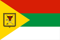
Tungiro-Olyokminsky District ?–present Flag of Ulyotovsky District ?–present Flag of Chernyshevsky District ?–present Flag of ChitinskyDistrict ?–present Flag...
settlement in ChitinskyDistrict of Zabaykalsky Krai Rural localities Yablonovo, Chernyansky District, Belgorod Oblast, a khutor in Chernyansky District of Belgorod...
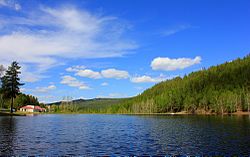
112.833 Arakhley (Russian: Арахлей) is a rural locality (a selo) in ChitinskyDistrict of Zabaykalsky Krai, located on the southwest bank of Arakhley Lake...
Новокручининский) is an urban locality (an urban-type settlement) in ChitinskyDistrict of Zabaykalsky Krai, Russia. Population: 10,166 (2010 Russian census);...
(disambiguation) Chitas, a Hebrew acronym for Chumash, Tehillim, and Tanya Chitinsky (disambiguation) adjective This disambiguation page lists articles associated...
Cherepovetsky District As of 2022, one rural locality in Zabaykalsky Krai bears this name: Yagodny, Zabaykalsky Krai, a settlement in ChitinskyDistrict This article...
Pereslavsky District As of 2012, one rural locality in Zabaykalsky Krai bears this name: Ilyinka, Zabaykalsky Krai, a selo in ChitinskyDistrict Ilyinka,...
This is a list of districts of Russia. A district (raion) is an administrative and municipal division of a federal subject of Russia. Within the framework...
 Global Information