Arm of the Gulf of Saint Lawrence between Quebec and New Brunswick, Canada
For the bay in Newfoundland and Labrador, see Chaleur Bay (Newfoundland and Labrador).
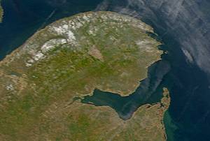
Satellite image of Chaleur Bay (NASA). Chaleur Bay is the large bay in the centre of the image; the Gaspé Peninsula is to the north and the Gulf of St. Lawrence is seen to the east.
Chaleur Bay, also Chaleurs Bay, Bay of Chaleur[1][2] (in French: Baie des Chaleurs[3]), is an arm of the Gulf of Saint Lawrence located between Quebec and New Brunswick, Canada.[3]
The name of the bay is attributed to explorer Jacques Cartier (Baie des Chaleurs). It translates into English as "bay of warmth" or "bay of torrid weather".
Chaleur Bay is the 31st member of the Most Beautiful Bays of the World Club.[4][5]
Chaleur Bay is host to an unusual visual phenomenon, the Fireship of Chaleur Bay, an apparition of sorts resembling a ship on fire which has reportedly appeared at several locations in the bay. It is possibly linked to similar sightings several hundred kilometres to the south where the Fireship of Northumberland Strait has been seen in the Northumberland Strait. This may have given rise to a phantom ship legend, which dates back more than two centuries. [citation needed] The story (and witnesses) claim that a sailing ship burned in the waters north of the city of Campbellton, New Brunswick on the Restigouche River, possibly from the Battle of the Restigouche, and is visible in certain weather and light conditions. A drawing of a ghost wielding an anchor and menacing two sailors can be seen on the city's welcome sign. [citation needed]
^Gouvernement du Canada, Travaux publics et Services gouvernementaux Canada (2009-10-08). "CHALEUR BAY [2 fiches] - TERMIUM Plus® — Recherche - TERMIUM Plus®". www.btb.termiumplus.gc.ca. Retrieved 2020-11-08.
^also known informally in English as Bay of Chaleur due to the influence of its French translation
^ ab"Names of pan-Canadian significance". Geographical Names Board of Canada. Archived from the original on 2013-11-05. Retrieved 2013-11-05.
^"Www.World-Bays.Com - Le Club Des Plus Belles Baies Du Monde". Archived from the original on 2005-10-18. Retrieved 2005-10-27.
^Gagné, Gilles (2004). "Baie des Chaleurs now part of the Most Beautiful Bays in the World Club". www.gogaspe.com. Retrieved 2020-11-08.
ChaleurBay, also ChaleursBay, Bay of Chaleur (in French: Baie des Chaleurs), is an arm of the Gulf of Saint Lawrence located between Quebec and New Brunswick...
The Baie Chaleur Fireship, more commonly referred to as the Chaleur Phantom or the Phantom Ship, is a form of ghost light, an unusual visual phenomenon...
Look up chaleur in Wiktionary, the free dictionary. Chaleur (French for "warmth") may refer to: ChaleurBay, or Baie des Chaleurs in Canada between Quebec...
l'Esker Bay") Waconichi River (via Du Poste Bay) Waconichi Lake Bignell River (Waconichi River) Pipounichouane River (via "Des Plongeurs Bay") De Maurès...
reached the head of Bay of Fundy. From the Gaspereau center, on the divide crossing New Brunswick flowed into the Bay of Fundy and ChaleurBay. In New York,...
largest city is Carleton-sur-Mer. It is on the Gaspé Peninsula, along ChaleurBay. There are 13 subdivisions and 2 native reserves within the RCM: Canada...
expansion set include Black Aggie, the Black Dog of the Hanging Hills, the ChaleurBay Ghost Ship, the Chasse-Galerie, D.C. the Demon Cat, Edgar Cayce, the...
(#68) Green Bay-Appleton (#69) Roanoke-Lynchburg (#70) Omaha (#71) Wichita-Hutchinson Plus (#72) Springfield, MO (#73) Flint-Saginaw-Bay City (#74) Columbia...
in 1534, when his party set foot in Miscou and explored the coasts of ChaleurBay. They made contact with aboriginals, who from this point on began to...
The Chemin de fer Baie des Chaleurs (reporting mark CBC) (in English, the ChaleurBay Railway) was a short line railway that operated in eastern Québec...
discharge basins: the Gulf of Saint Lawrence to the east and north and the Bay of Fundy to the south. The major rivers are the Saint John River (Wolastoq)...
hunting of the Magdalen Islands' walruses, with the last in 1597. The ChaleurBay, separating Quebec and New Brunswick, also began to experience Basque...
uk. Retrieved 15 December 2012. "Diffused Lighting and its use in the ChaleurBay". Naval Museum of Quebec. Royal Canadian Navy. Archived from the original...
2015. "Naval Museum of Quebec". Diffused Lighting and its use in the ChaleurBay. Royal Canadian Navy. Archived from the original on 22 May 2013. Retrieved...
around the coast of New Brunswick and Nova Scotia from the south shore of ChaleurBay and includes Prince Edward Island and Îles-de-la-Madeleine." "Physiographic...
in Gloucester County, New Brunswick, Canada. Situated on the shore of ChaleurBay in the Acadian Peninsula, its name is derived from the Mi'kmaq term for...
source in the Appalachian Mountains of northwestern New Brunswick to ChaleurBay. Its meander length is approximately 200 kilometres (120 mi). The Restigouche...
Bay (from the Mi’kmaq word winpegijawik, which means "rough water") is located in northern New Brunswick, Canada on the southern part of the Chaleur Bay...
rises in the Chic-Choc Mountains and flows south to empty into Baie des Chaleurs near the town of Bonaventure, Quebec. The river is about 115 km (71 mi)...
 Global Information