 Global Information
Cattaraugus Creek information
| Cattaraugus Creek | |
|---|---|
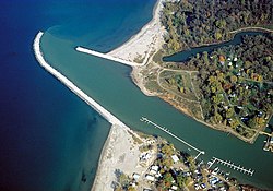 The mouth of Cattaraugus Creek on Lake Erie near Sunset Bay, New York. | |
 Cattaraugus Creek Watershed (Interactive map) | |
 Location of the mouth of Cattaraugus Creek in New York State.  Cattaraugus Creek (the United States) | |
| Location | |
| Country | United States |
| State | New York |
| Physical characteristics | |
| Source | Java Lake |
| • location | Java, Wyoming County |
| • coordinates | 42°37′43″N 78°20′24″W / 42.62861°N 78.34000°W[1] |
| Mouth | Lake Erie |
• location | Sunset Bay, Erie County |
• coordinates | 42°34′14″N 79°08′14″W / 42.57056°N 79.13722°W[1] |
| Length | 68 mi (109 km)[2] |
| Basin size | 559 sq mi (1,450 km2)[2] |
Cattaraugus Creek is a stream, approximately 68 miles (109 km) long, in western New York in the United States.[1][2][3][4] The creek drains a wooded rural portion of western New York southwest of Buffalo into Lake Erie.[2][3][4] In its lower course it flows primarily through the Cattaraugus Reservation of the Seneca tribe.[2][3][4] William Beauchamp identifies the name Cattaraugus as deriving from the Seneca word Gah-ta-ra-ke-ras, meaning "stinking shore" or "foul-smelling river bank."[5] This in turn is likely a loanword from an extinct Attiwandiron, Erie, Wenro, or Wendat (Huron) language, combining the verb root -i'tar-, referring to clay or mud,[6] and -akera(n)-, describing a bad or strong odor:[7] hence, tke'tarakeras, place of strong-smelling mud or clay. (The Seneca language does not have a distinct R sound; the Seneca language equivalent, Canawaugus, was originally used for a site further east.[8]) This name is a result of the natural gas that oozes from the river mud.
- ^ a b c "Cattaraugus Creek". Geographic Names Information System. United States Geological Survey, United States Department of the Interior. Retrieved March 22, 2015.
- ^ a b c d e Gravel mining; Summary of permits for mining activities in the Cattaraugus Creek watershed, Cattaraugus Creek watershed resource guide and proposed watershed planning strategy, 2006, Boyer, B., Carpenter, B., Renschler, C., & Kellam, R.V., Funded by: U.S. Environmental Protection Agency Great Lakes National Program Office, U.S. Army Corps of Engineers Buffalo District, Retrieved 21 June 2014.
- ^ a b c Kirby, C.D. (1976). The Early History of Gowanda and The Beautiful Land of the Cattaraugus. Gowanda, NY: Niagara Frontier Publishing Company, Inc./Gowanda Area Bi-Centennial Committee, Inc.
- ^ a b c Historical sketch of the Village of Gowanda, N.Y. in commemoration of the fiftieth anniversary of its incorporation, August 8, 1898. Buffalo, NY: The Matthews-Northrup Company, Leonard, I.R., Reprinted 1998, Salem, MA: Higginson Book Company.
- ^ Beauchamp, William Martin (1907). Aboriginal Place Names of New York (New York State Museum Bulletin, Volume 108). New York State Education Department. p. 31. ISBN 9781404751552. Retrieved 27 February 2015.
- ^ Kanatawakhon, David. Karoron Ne Owennashonha (Mohawk Language Thematic Dictionary. London, ON: University of Western Ontario Press, 2001.
- ^ Kanatawakhon, David. Akwekon Tetewakhanyon (Let's Put It All Together): Mohawk Language Course Dictionary. London, ON: University of Western Ontarion Press, 2003.
- ^ Czamota, Lorna (2014). Native American & Pioneer Sites of Upstate New York. The History Press. p. 140. ISBN 9781626192904.