 Global Information
Catawba River information
| Catawba River | |
|---|---|
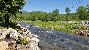 A view of the Catawba River in McDowell County, North Carolina | |
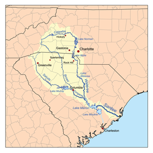 Map of the Santee River watershed showing the Catawba River | |
 Location of the mouth of the Catawba River in South Carolina | |
| Etymology | Named after the Catawba Indians[2] |
| Native name | Eswa-Taroa (Catawba)[1] |
| Location | |
| Country | United States |
| States | North Carolina, South Carolina |
| Counties | McDowell NC, Caldwell NC, Burke NC, Alexander NC, Catawba NC, Iredell NC, Lincoln NC, Gaston NC, Mecklenburg NC, York SC, Lancaster SC, Fairfield SC |
| Physical characteristics | |
| Source | Evans Knob[3] |
| • location | Ridgecrest, North Carolina |
| • coordinates | 35°36′04″N 82°17′06″W / 35.60111°N 82.28500°W[1] |
| • elevation | 3,044 ft (928 m) |
| Mouth | Wateree River |
• location | Liberty Hill, South Carolina |
• coordinates | 34°28′01″N 80°53′20″W / 34.46694°N 80.88889°W[1] |
• elevation | 223 ft (68 m)[1] |
| Basin features | |
| Progression | Catawba → Wateree → Santee → Atlantic Ocean |
| River system | Catawba River |
| Waterbodies | Lake James, Rhodhiss Lake, Lake Hickory, Lookout Shoals Lake, Lake Norman, Mountain Island Lake, Lake Wylie, Fishing Creek Reservoir,Great Falls Reservoir, Cedar Creek Reservoir, Lake Wateree |
| Waterfalls | Catawba Falls |
The Catawba River is a major river located in the Southeastern United States. It originates in Western North Carolina and flows into South Carolina, where it later becomes known as the Wateree River. The river is approximately 220 miles (350 km) long. It rises in the Appalachian Mountains and drains into the Piedmont, where it has been impounded through a series of reservoirs for flood control and generation of hydroelectricity. The river is named after the Catawba tribe of Native Americans, which lives on its banks. In their language, they call themselves "yeh is-WAH h’reh", meaning "people of the river."[4]
The river rises in the Blue Ridge Mountains in western McDowell County, North Carolina, approximately 20 miles (30 km) east of Asheville. It flows ENE, falling over two waterfalls, Upper Catawba Falls and Catawba Falls, before being dammed by Lake James, and joining the Linville River. It passes north of Morganton, then southeast through Lake Rhodhiss and Lake Hickory just north of Hickory, and into the Lake Norman reservoir. From Lake Norman it flows south, passing west of Charlotte, then flowing through the Mountain Island Lake and Lake Wylie reservoirs, where it exits the reservoirs approximately 10 miles (15 km) south of the border between North Carolina and South Carolina. The confluence of the South Fork Catawba River and Catawba River is submerged by Lake Wylie near the NC/SC state line.
The river flows into northern South Carolina, passing Rock Hill, through Fishing Creek Reservoir near Great Falls, and into the Lake Wateree reservoir, approximately 30 miles (50 km) northeast of Columbia. At the now-submerged confluence with Wateree Creek, it becomes known as the Wateree River.
- ^ a b c d "Catawba River". Geographic Names Information System. United States Geological Survey, United States Department of the Interior. June 17, 1980. Retrieved December 28, 2020.
- ^ "North Carolina Gazetteer". Archived from the original on June 23, 2022. Retrieved December 28, 2020.
- ^ "Evans Knob". Geographic Names Information System. United States Geological Survey, United States Department of the Interior. June 17, 1980. Retrieved December 28, 2020.
- ^ "The Catawba Nation - About The Nation". www.catawba.com. Retrieved Jan 22, 2023.