This article needs additional citations for verification. Please help improve this article by adding citations to reliable sources. Unsourced material may be challenged and removed. Find sources: "Caprock Escarpment" – news · newspapers · books · scholar · JSTOR(December 2009) (Learn how and when to remove this message)
Caprock Escarpment
Escarpment
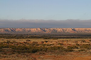
Caprock Escarpment, Garza County, Texas
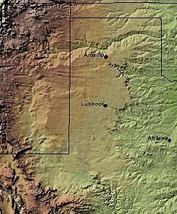
The Caprock Escarpment marking the edge of the Llano Estacado is clearly visible in this shaded relief image. The escarpment can be seen on the eastern edge of the Llano, running roughly in a north–south line through the middle of the Panhandle of Texas.
Northwest escarpment of the Llano Estacado overlooking Alamogordo Valley of Quay and Guadalupe Counties, New Mexico.
The Caprock Escarpment is a term used in West Texas and Eastern New Mexico to describe the geographical transition point between the level High Plains of the Llano Estacado and the surrounding rolling terrain.[1]
In Texas, the escarpment stretches around 200 mi (320 km) south-southwest from the northeast corner of the Texas Panhandle near the Oklahoma border. The escarpment is especially notable, from north to south, in Briscoe, Floyd, Motley, Crosby, Dickens, Garza, and Borden Counties.
In New Mexico, a prominent escarpment exists along the northernmost extension of the Llano Estacado, especially to the south of San Jon and Tucumcari, both in Quay County, New Mexico. Along the western edge of the Llano Estacado, the portion of the escarpment that stretches from Caprock to Maljamar, New Mexico, is called the Mescalero Ridge.[2][3]
^Carroll, H.B. "Caprock". Handbook of Texas Online. Retrieved March 1, 2013.
^Price, A.P. 1977. Mescalero Sandhills of Cochran and Yoakum Counties, Texas. Master's thesis, Texas Tech University, Lubbock, 253 pp.
^Henderson, D. 2006. An Introduction to the Mescalero Sands Ecosystem. Master's thesis, Texas A&M University, 42 pp.
and 17 Related for: Caprock Escarpment information
The CaprockEscarpment is a term used in West Texas and Eastern New Mexico to describe the geographical transition point between the level High Plains...
layer. The Niagara Escarpment, over which Niagara Falls flows, is an example of a scarp or escarpment. At Niagara Falls, the caprock is the riverbed above...
Escarpment (Wisconsin) Book Cliffs (Colorado–Utah) CaprockEscarpment (Texas) Catskill Escarpment (New York) The Chinese Wall (Montana) Cody Scarp (Florida)...
States in New Mexico and Texas. It is the western equivalent of the CaprockEscarpment, which defines the eastern edge of the Llano Estacado. Extending north-south...
rock layers occurs at the escarpment, which is not a fault line but the result of unequal erosion. The escarpment'scaprock is dolomitic limestone, also...
distinct from North Texas, which is further south and east. West of the CaprockEscarpment and North and South of the Canadian River breaks, the surface of the...
separating it from the rest of the High Plains. To the east, the CaprockEscarpment, a precipitous cliff about 300 feet (100 m) high, lies between the...
National Historic Site. The North Central Plains are bounded by the CaprockEscarpment to the west, the Edwards Plateau to the south, and the Eastern Cross...
Caprock Canyons State Park and Trailway is a Texas state park located along the eastern edge of the Llano Estacado in Briscoe County, Texas, United States...
overlying a weaker or less resistant rock type, and lends its name to the CaprockEscarpment that defines the edge of the high plains of the Llano Estacado. The...
Palo Duro Canyon is a canyon system of the CaprockEscarpment located in the Texas Panhandle near the cities of Amarillo and Canyon. As one of the largest...
Colorado Springs founder William Jackson Palmer, the Palmer Divide is a caprockescarpment-style ridge in central Colorado that separates the Arkansas River...
resistant stratum or strata, called caprock. The outcrop of the caprock forms a steeper or even cliff-like frontslope (escarpment), cutting through the dipping...
by sandstones. The resistant layer acts as a caprock that forms the flat summit of a mesa. The caprock can consist of either sedimentary rocks such as...
located in the U.S. state of Texas. Eroded by the White River into the CaprockEscarpment on the east side of the Llano Estacado, the canyon runs for 34 miles...
part of a larger pine-hardwood forest. The Cross Timbers region and CaprockEscarpment are part of the Interior Lowlands. The Great Plains region in Central...
 Global Information