You can help expand this article with text translated from the corresponding article in French. (November 2012) Click [show] for important translation instructions.
View a machine-translated version of the French article.
Machine translation, like DeepL or Google Translate, is a useful starting point for translations, but translators must revise errors as necessary and confirm that the translation is accurate, rather than simply copy-pasting machine-translated text into the English Wikipedia.
Do not translate text that appears unreliable or low-quality. If possible, verify the text with references provided in the foreign-language article.
You must provide copyright attribution in the edit summary accompanying your translation by providing an interlanguage link to the source of your translation. A model attribution edit summary is Content in this edit is translated from the existing French Wikipedia article at [[:fr:Cap de la Hague]]; see its history for attribution.
You may also add the template {{Translated|fr|Cap de la Hague}} to the talk page.
For more guidance, see Wikipedia:Translation.
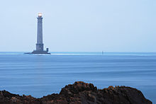
Cape of la Hague with Cherbourg on the leftThe La Hague lighthouse [fr]
Cap de la Hague is a cape at the tip of the Cotentin peninsula in Normandy, France.
The La Hague area has precambrian granite and gneiss cliffs, several coves and small fields surrounded by hedges. France's oldest rocks are to be found on its coast in Jobourg.[1] Other rocky outcroppings on the coast include Cadomian granite in Auderville[2] and Variscan granite in Flamanville.[3]
The La Hague cape consists of two promontories about half a mile apart. The cape itself, which has the lighthouse and a lifeboat station, is very low-lying.
The dialect of the Norman language spoken by a minority in the region is called Haguais. The Norman poet Côtis-Capel was a native of the region and used the landscape as inspiration for his poetry. The painter Jean-François Millet was also a native of the region.
The La Hague site, the largest light water reactor nuclear waste reprocessing plant on earth (over half of the world's capacity), is located in the region.
^La Presse de la Manche, 27 August 2009, p. 5
^Cadomian Granite Archived 6 July 2014 at the Wayback Machine Website Lithothèque de Normandie.
^Alain Foucault. Guide du géologue amateur. Éditions Dunod. p. 182. ISBN 978-2-10-049959-5 .
CapdelaHague is a cape at the tip of the Cotentin peninsula in Normandy, France. The LaHague area has precambrian granite and gneiss cliffs, several...
Islands both to France and to the United Kingdom. It is separated from CapdelaHague by the dangerous Alderney Race (French: Raz Blanchard). As of March...
three areas: the headland of CapdelaHague, the Cotentin Pass (the Plain), and the valley of the Saire River (Val de Saire). It forms the bulk of the...
made up Groups C and D. These three groups headed for a position near CapdelaHague. Group B (the destroyers Brocklesby, Fernie, Tynedale and the Polish...
cruise. The Allied force headed at speed for an interception point near CapdelaHague. 2 MTB flotillas were following 5 destroyers. Drayson was in the second...
the Divette [fr] and at the south of the bay between Cap Lévi [fr] to the east and CapdeLaHague to the west, Cherbourg-Octeville is 120 km (75 mi) from...
L’Ambiteux. On 21 May, the French fleet was anchored against the tide off CapdelaHague. The leading contingent, 21 ships—now under Pannetier—had rounded the...
running in a line from the northeast of Carentan, via Barfleur-Cherbourg-CapdelaHague to a point west of Barneville. This included the 65 km land front of...
communes of CapdeLaHague (Auderville and Saint-Germain-des-Vaux) where one pronounces [chanhanto] /ʃaɔ̃to/. The dialect of the Val de Saire, pronounces...
the pursuit after Barfleur; Tourville's squadron, unable to round CapdelaHague with the rest of his fleet, and with anchors dragging in a strong flood...
sites were added by mid-September 1940: a DeTe-Gerät at CapdelaHague and a FernDeTe-Gerät long-range radar at Cap d’Antifer near Le Havre. The 38 cm SK...
when the U.S. 9th Infantry Division managed to reduce the defenses of CapdelaHague, north-west of the port. Within four days, VII Corps (Major General...
followed by eight Motor Torpedo Boats sailed from Dartmouth to patrol off CapdelaHague, while a second group of four destroyers were to wait off the Channel...
March 1990, Pointe de Chémoulin, Saint-Nazaire Loire-Atlantique 1048.9 hPa. Lowest air pressure: 25 February 1989, CapdeLaHague, Cherbourg 951.8 hPa...
ship SS Saint Prosper, which had struck a rock in Alderney Race off CapdelaHague on the Cotentin Peninsula. On 10 July 1935, she was the flagship of...
radar sites were added by mid-September: a DeTeGerät at CapdelaHague and a FernDeTeGerät long-range radar at Cap d’Antifer near Le Havre. To strengthen...
commerce raider was attacked by British motor torpedo boats near the CapdelaHague. She was hit by a torpedo from MTB 236 and sank with no survivors....
radar sites were added by mid-September: a DeTeGerät at CapdelaHague and a FernDeTeGerät long-range radar at Cap d’Antifer near Le Havre. The longest-ranged...
William Jefferson Hague, Baron Hague of Richmond, PC, FRSL (born 26 March 1961) is a British politician and life peer who served as Leader of the Conservative...
aircraft attacked the German ships. The minesweeper M 26 was sunk off CapdelaHague and M 256 was badly damaged. On 19 May Stier reached Gironde, and broke...
 Global Information