 Global Information
Cambridgeshire information
Cambridgeshire | |
|---|---|
Ceremonial county | |
| |
 Ceremonial Cambridgeshire within England  Historic Cambridgeshire in the British Isles | |
| Coordinates: 52°20′N 0°0′W / 52.333°N -0.000°E | |
| Sovereign state | United Kingdom |
| Constituent country | England |
| Region | East of England |
| Established | 1 April 1974 |
| Established by | Local Government Act 1972 |
| Preceded by | Cambridgeshire and Isle of Ely Huntingdon and Peterborough |
| Origin | Ancient |
| Time zone | UTC+0 (GMT) |
| • Summer (DST) | UTC+1 (BST) |
| Members of Parliament | List of MPs |
| Police | Cambridgeshire Constabulary |
| Ceremonial county | |
| Lord Lieutenant | Julie Spence[1] |
| High Sheriff | Dr Bharatkumar N Khetani (2023-24) |
| Area | 3,389 km2 (1,309 sq mi) |
| • Ranked | 15th of 48 |
| Population (2022) | 852,523 |
| • Ranked | 28th of 48 |
| Density | 252/km2 (650/sq mi) |
| Ethnicity | 94.6% White 2.6% S.Asian |
| Non-metropolitan county | |
| County council | Cambridgeshire County Council |
| Executive | Conservative |
| Admin HQ | New Shire Hall, Alconbury Weald |
| Area | 3,046 km2 (1,176 sq mi) |
| • Ranked | 8th of 21 |
| Population | 689,109 |
| • Ranked | 17th of 21 |
| Density | 226/km2 (590/sq mi) |
| ISO 3166-2 | GB-CAM |
| ONS code | 12 |
| GSS code | E10000003 |
| ITL | UKH12 |
| Website | cambridgeshire |
| Unitary authorities | |
| Councils | Peterborough City Council |
| Districts | |
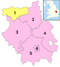 Districts of Cambridgeshire Unitary County council area | |
| Districts |
|


Cambridgeshire (abbreviated Cambs.) or the County of Cambridge is a ceremonial county and historic county in the East of England and East Anglia. It is bordered by Lincolnshire to the north, Norfolk to the north-east, Suffolk to the east, Essex and Hertfordshire to the south, and Bedfordshire and Northamptonshire to the west. The largest settlement is the city of Peterborough, and the city of Cambridge is the county town.
The county has an area of 3,389 km2 (1,309 sq mi) and a population of 852,523. Peterborough and Cambridge, located in the north-west and south respectively, are by far the largest settlements. The remainder of the county is rural, and contains the city of Ely, and towns such as Wisbech and St Neots.
For local government purposes, Cambridgeshire comprises a non-metropolitan county, with five districts, and the unitary authority area of Peterborough. The local authorities collaborate through Cambridgeshire and Peterbrough Combined Authority. The county did not historically include Huntingdonshire or the Soke of Peterborough, which was part of Northamptonshire.
The north and east of the county are dominated by the Fens, an extremely flat, drained marsh maintained by drainage ditches and dykes. Holme Fen is the UK's lowest physical point, at 2.75 m (9 ft) below sea level. The flatness of the landscape makes the few areas of higher ground, such as that Ely is built on, very conspicuous. The landscape in the south and west is gently undulating. Cambridgeshire's principal rivers are the Nene, which flows through the north of the county and is canalised east of Peterborough; the Great Ouse, which flows from west to east past Huntingdon and Ely; and the Cam, a tributary of the Great Ouse which flows through Cambridge.[2]
- ^ "Lord Lieutenant". Archived from the original on 17 September 2017. Retrieved 22 January 2018.
- ^ . Encyclopædia Britannica. Vol. 5 (11th ed.). 1911. pp. 97–99.