California bikeway classifications are standards for identifying the level of travel efficiency and human protection offered by the various bike routes in the state. Traffic engineers use the designations for route planning.
Bikeway class
Photo
Common name
CalTrans definition
Further info
Examples
Class I
BIKE PATH
“Bike paths should offer opportunities not provided by the road system. They can either provide a recreational opportunity, or in some instances, can serve as direct high-speed commute routes if cross flow by motor vehicles and pedestrian conflicts can be minimized. The most common applications are along rivers, ocean fronts, canals, utility right of way, abandoned railroad right of way, within school campuses, or within and between parks. Another common application of Class I facilities is to close gaps to bicycle travel caused by construction of freeways or because of the existence of natural barriers (rivers, mountains, etc.).”[1]
“off-roadway bike paths or bike trails” [2]
Coyote Creek Trail, Ballona Creek Bike Path
Class II
BIKE LANE
“Bike lanes are established along streets in corridors where there is significant bicycle demand, and where there are distinct needs that can be served by them... Bike lanes are intended to delineate the right of way assigned to bicyclists and motorists and to provide for more predictable movements by each.”[1]
“on-roadway, separated (striped) bike lanes”[2]
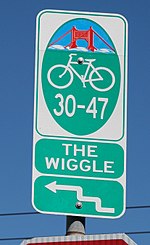
Class III
BIKE ROUTE
“Bike routes are shared facilities which serve either to: (a) Provide continuity to other bicycle facilities (usually Class II bikeways) or (b) Designate preferred routes through high demand corridors. Normally, bike routes are shared with motor vehicles. The use of sidewalks as Class III bikeways is strongly discouraged.“[1]
“on-roadway, signed (but not separated) bike lanes[2] - Sharrows
The Wiggle
Class IV
SEPARATED BIKEWAY
“A bikeway for the exclusive use of bicycles and includes a separation required between the separated bikeway and the through vehicular traffic. The separation may include, but is not limited to, grade separation, flexible posts, inflexible posts, inflexible barriers, or on-street parking.”[1]
Telegraph Ave., Oakland; Elenda Bikeway, Culver City; Venice Blvd., Mar Vista, Los Angeles; Canyon Crest Ave., Riverside
^ abc
Brundige, Don; Brundige, Sharron (2007). Cycling Los Angeles (2nd ed.). San Diego, Calif.: Sunbelt Publications. p. xxiv. ISBN 978-0-932653-81-9.
and 13 Related for: California bikeway classifications information
Californiabikewayclassifications are standards for identifying the level of travel efficiency and human protection offered by the various bike routes...
about the halfway point along the route. Rails with trails Californiabikewayclassifications List of Los Angeles bike paths There is a distance of 2.1...
bike paths Californiabikewayclassifications "SANDAG ::PROJECTS:: San Diego's Regional Planning Agency". "Coastal Rail Trail: Rose Creek Bikeway" (PDF)....
Cycling infrastructure is all infrastructure cyclists are allowed to use. Bikeways include bike paths, bike lanes, cycle tracks, rail trails and, where permitted...
Veloway List of San Diego bike paths California Cycleway Bicycle infrastructure Californiabikewayclassifications "Bicycle Maps". LADOT Bicycle Services...
June 2019, the City of Los Angeles began construction on the Taylor Yard Bikeway and Pedestrian Bridge to connect Taylor Ward with Elysian Valley on the...
was named 12373 Lancearmstrong in honor of him. Six-mile Lance Armstrong Bikeway through downtown Austin, Texas, built by the city of Austin at a cost of...
with over 160 miles of dedicated bikeways. The city is currently in the process of expanding its on and off street bikeway network.[when?] In 2015, Downtown...
power. Consequently, any particular e-bike may be subject to different classifications and regulations in different jurisdictions. In Australia, the e-bike...
(26 km) of on-street protected bikeways, 98 miles (158 km) of bike lanes and 101 miles (163 km) of off-street bikeways and trails. Off-street facilities...
obesity by changing ordinances to encourage construction of sidewalks, bikeways, and other places for physical activity. A report of the National Conference...
providing a connection to the University of Houston and other downtown bikeways and destinations. Metropolitan Transit Authority of Harris County, Texas...
 Global Information