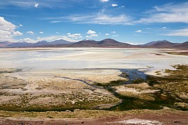
The complex is visible at the centre of the image. Salar de Capur (left) and Salar de Talar (right).
Caichinque is a volcanic complex lying between Salar de Talar and Salar de Capur, in the high Andean plateau of the Antofagasta Region, in Chile. It is located southwest of the Salar de Atacama, directly S of Cerro Miñiques and SE of Cordón Puntas Negras forming part of the main branch of the Andean volcanic chain in this area.
Route CH-23 is an approach road to the volcano area and could be impacted by eruptions.[1]
The volcano has erupted rocks with composition ranging from basalt to dacite. It grew atop a rhyodacitic ignimbrite.[1]
^ abAmigo, Álvaro R.; Bertin, Daniel U.; Orozco, Gabriel L. (2012). Peligros volcánicos de la Zona Norte de Chile (PDF) (Report). Carta geológica de Chile: Serie Geología Ambiental (in Spanish). Vol. 17. SERVICIO NACIONAL DE GEOLOGÍA Y MINERÍA. p. 20. ISSN 0717-7305. Archived from the original (PDF) on June 29, 2021. Retrieved 20 August 2021.
Caichinque is a volcanic complex lying between Salar de Talar and Salar de Capur, in the high Andean plateau of the Antofagasta Region, in Chile. It is...
Chiliques Laguna Miscanti Cordón Puntas Negras Los Flamencos National Reserve Caichinque "Chilean IGM". Archived from the original on 2007-09-29. Retrieved 2007-03-28...
connected to Salar Purisunchi. The salty flat is bordered on the west by Caichinque and on the east by Cerro Medano. This latter is a mountain with striking...
December 9. The event had a hypocenter depth of 113.9 km, beneath the Caichinque volcanic complex. It measured magnitude Mw 8.2 on the moment magnitude...
southeastward from Incahuasi Sur, the Calama–Olacapato–El Toro fault. Caichinque Cerro Miscanti Miñiques "IGM - Producto". Archived from the original on...
 Global Information