Comprehensive register of the real estate or real property's metes-and-bounds of a country
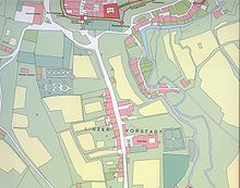
Cadastral map from 1827 in Austria (Franziszeischer Kataster [de])A modern cadastral map for Eastern England
A cadastre or cadaster is a comprehensive recording of the real estate or real property's metes-and-bounds of a country.[1][2]
Often it is represented graphically in a cadastral map.
In most countries, legal systems have developed around the original administrative systems and use the cadastre to define the dimensions and location of land parcels described in legal documentation.
A land parcel or cadastral parcel is defined as "a continuous area, or more appropriately volume, that is identified by a unique set of homogeneous property rights".[3]
Cadastral surveys document the boundaries of land ownership, by the production of documents, diagrams, sketches, plans (plats in the US), charts, and maps. They were originally used to ensure reliable facts for land valuation and taxation. An example from early England is the Domesday Book in 1086. Napoleon established a comprehensive cadastral system for France that is regarded as the forerunner of most modern versions.
Cadastral survey information is often a base element in Geographic Information Systems (GIS) or Land Information Systems (LIS) used to assess and manage land and built infrastructure. Such systems are also employed on a variety of other tasks, for example, to track long-term changes over time for geological or ecological studies, where land tenure is a significant part of the scenario.
The cadastre is a fundamental source of data in disputes and lawsuits between landowners.
Land registration and cadastre are both types of land recording and complement each other.[2]
Cadastral map of Bozen, Tirol, Brixner Kreis Nr 1, 1858
^Cite error: The named reference CTdata was invoked but never defined (see the help page).
^ abJo Henssen, Basic Principles of the Main Cadastral Systems in the World, [1]
^Dale, Peter; McLaughlin, John (2000). Land Administration. Oxford University Press. doi:10.1093/oso/9780198233909.001.0001. ISBN 9780198233909.
A cadastre or cadaster is a comprehensive recording of the real estate or real property's metes-and-bounds of a country. Often it is represented graphically...
The Federal Service for State Registration, Cadastre and Cartography (Rosreestr) (Russian: Федеральная служба государственной регистрации, кадастра и картографии...
OVO Sound (acronym of October's Very Own) is a Canadian independent record label, founded in 2012 by rapper Drake, producer 40, and manager Oliver El-Khatib...
agency, dealing with land surveying, geodesy, hydrographic surveying, cadastre and cartography. The current director is Johnny Welle. Its headquarters...
Agency (GST) (Danish: Geodatastyrelsen), (previously National Survey and Cadastre of Denmark (Danish: Kort & Matrikelstyrelsen, KMS)), is the Danish state...
France (IGN) 551,695 km2 (213,011 sq mi) (50th) • Metropolitan France (Cadastre) 543,940.9 km2 (210,016.8 sq mi) (50th) Population • January 2024 estimate...
In 1749 a large-scale census and statistical investigation was conducted in the Crown of Castile (15.000 castilian places; excluded the Basque provinces...
Nan Cadastre is a village in the Croix-des-Bouquets commune of the Croix-des-Bouquets Arrondissement, in the Ouest department of Haiti. Croix-des-Bouquets...
on September 15, 2023. The song was produced by Drake himself and Noel Cadastre and co-produced by 40, Bnyx, and Dalton Tennant. It debuted at number one...
September 15, 2023. The R&B song was produced by Drake himself and Noel Cadastre and co-produced by 40, Bnyx, and Dalton Tennant, and written by the five...
record producers, including Boi-1da, London on da Track, Nineteen85, Noel Cadastre and Popcaan himself. It features guest appearances from Drake, Dane Ray...
more equitably, by assessing the overall revenues of each parish. This cadastre was not yet drawn up by parcel, but by large masses of crops within each...
James; the song is Roxx's first production credit. Drake's engineer Noel Cadastre, a member of Drake's OVO crew, produced "Chicago Freestyle" and "Not You...
task of producing logarithmic and trigonometric tables for the French Cadastre (geographic survey). The effort was sanctioned by the French National Assembly...
nondisclosure agreement, and user guide Geography and planning: topographic map, cadastre, legend, and architectural plan Such standard documents can be drafted...
Wiktionary, the free dictionary. A defter was a type of tax register and land cadastre in the Ottoman Empire. The term is derived from Greek diphthera διφθέρα...
Cadastral surveying is the sub-field of cadastre and surveying that specialises in the establishment and re-establishment of real property boundaries....
set up to continue, by adopting the procedures instituted in Europe, the cadastre work inaugurated under Muhammad Ali. This Commission suggested to Viceroy...
и бројевима". hramsvetogsave.rs. Retrieved 23 November 2019. Official cadastre, parcel 18919/2 Church of Saint Sava "Организација унутрашњег простора...
 Global Information