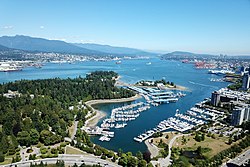
Burrard Inlet (Halkomelem: səl̓ilw̓ət) is a shallow-sided fjord in the northwestern Lower Mainland, British Columbia, Canada.[1][2] Formed during the last Ice Age, it separates the City of Vancouver and the rest of the lowland Burrard Peninsula to the south from the coastal slopes of the North Shore Mountains, which span West Vancouver and the City and District of North Vancouver to the north.
Burrard Inlet opens west into the Strait of Georgia between Point Atkinson and Point Grey. Vancouver's Downtown Peninsula protrudes northwesterly into the inlet, separating it into the wide outer Burrard Inlet to the west and the elongated inner Burrard Inlet to the east. The southeastern portion of the outer inlet is an open bay known as English Bay, which has a narrow eastern inlet called False Creek. The 400-metre-wide (1,300 ft) strait between Prospect Point and the sandbanks just east of the Capilano River mouth, which connects the inlet's outer and inner sections, is known as the First Narrows, traversed by the Lions Gate Bridge. The inner inlet then widens into Vancouver Harbour, which hosts the Port of Vancouver, Canada's largest port.
At the eastern end of the harbour, Burrard Inlet narrows again into a 350-metre-wide (1,150 ft) strait between Burnaby Heights and the mouth of the Seymour River, known as the Second Narrows, which is traversed by the Ironworkers Memorial Bridge and the Second Narrows Rail Bridge. After the Second Narrows, it widens again and continues east until the headland near Dollarton, where it splits into two arms. The longer arm, known as Indian Arm, extends northerly between Mount Seymour and Eagle Mountain until it meets the deltas of Indian River mouth. The shorter arm, known as Port Moody Arm or Moody Inlet, courses further east for another 6 kilometres (3.7 mi) past a 320-metre-wide (1,050 ft) strait (traversed only by overhead powerlines) between Burnaby Mountain and the bluffs of Belcarra Regional Park. Port Moody Arm is almost completely encompassed by the City of Port Moody.
^"səl̓ilw̓ət (Sleilwaut) - Burrard Inlet/Indian Arm (Tsleil-Waututh) - The Bill Reid Centre - Simon Fraser University". www.sfu.ca. Retrieved 12 June 2021.
BurrardInlet (Halkomelem: səl̓ilw̓ət) is a shallow-sided fjord in the northwestern Lower Mainland, British Columbia, Canada. Formed during the last Ice...
following the exhibition, the derelict McBarge was anchored empty in BurrardInlet from 1991, amid industrial barges and an oil refinery, until it was...
ferry service in Metro Vancouver, British Columbia, Canada. It crosses BurrardInlet to connect the cities of Vancouver (at Waterfront station) and North...
Columbia. Formed during the last Ice Age, it extends due north from BurrardInlet, between the communities of Belcarra (to the east) and the District...
The Burrard Peninsula (Squamish: Ulksen) is a peninsula in the Lower Mainland region of British Columbia, Canada, bounded by the BurrardInlet to the north...
site. Gastown then formally registered as a townsite dubbed Granville, BurrardInlet. The city was renamed "Vancouver" in 1886 through a deal with the Canadian...
Vancouver and North Vancouver (district municipality) and empties into BurrardInlet, opposite Stanley Park. The river is one of three primary sources of...
the Burrard Peninsula, it neighbours the City of Vancouver to the west, the District of North Vancouver across the confluence of the BurrardInlet with...
needed] The street is named for BurrardInlet, located at its northern terminus, which in turn is named for Sir Harry Burrard-Neale. The street starts at...
side of the BurrardInlet, Richards thought he was traversing a creek; upon discovering his error, he gave the inlet its current name. The inlet opens into...
Narrows Rail Bridge is a vertical-lift railway bridge that crosses the BurrardInlet and connects Vancouver with the North Shore. The bridge's south end...
BurrardInlet in Vancouver, British Columbia, Canada. Originally named the Second Narrows Bridge, it connects Vancouver to the North Shore of Burrard...
exact numbers are unknown). Most residents escaped by fleeing to the BurrardInlet shore or the False Creek shore. Following the recovery efforts, the...
northwest of Vancouver, and the third of such inlets north of the 49th parallel, the first of which is BurrardInlet, Vancouver's harbour. It stretches 89 km...
March 4, 2024, Ross dared a 19-year-old man to drive his car into the BurrardInlet at Rocky Point Park in Port Moody, British Columbia, Canada. After the...
around Howe Sound only, but were invited to BurrardInlet by the Tsleil-waututh around 1800 to share that inlet after depopulation of the Tsleil-waututh...
Vancouver city decisions. Retrieved February 16, 2017. "New Burrard Otter makes a splash in BurrardInlet". TransLink. December 1, 2014. Retrieved May 16, 2017...
Rocky Point Park, also known as Rocky Point, is situated along BurrardInlet in Port Moody, British Columbia, next to the PoMo Museum. It is 3.8 hectares...
Tsleil-Waututh Nation, a Coast Salish band whose Indian reserve is located on BurrardInlet in the southeast area of the District of North Vancouver, British Columbia...
Burrard Neale died without issue at age 74 in 1840, and was buried at Lymington parish church. He was succeeded by his brother George. BurrardInlet was...
shore of the Burrard Peninsula in the Lower Mainland region of British Columbia. It occupies most of the north shore of the False Creek inlet, which cuts...
Belcarra is a village on the shore of Indian Arm, a side inlet of BurrardInlet, and is part of Metro Vancouver. It lies northwest of Port Moody and immediately...
Coal Harbour is a section of BurrardInlet lying between Vancouver's Downtown Peninsula and the Brockton Point of Stanley Park. It has also now become...
the proper name and postal address of which was Granville, B.I. ("BurrardInlet"). The official boundary does not include most of Hastings Street except...
 Global Information