Burgh and Tuttington is a civil parish in the English county of Norfolk.
It covers an area of 6.70 km2 (2.59 sq mi) and had a population of 255 in 115 households at the 2001 census,[2] increasing to a population of 322 in 140 households at the 2011 Census.
For the purposes of local government, it falls within the district of Broadland. The parish includes Burgh next Aylsham and Tuttington.
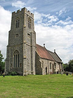
Burgh next Aylsham has a grade I listed church dedicated to Mary, which features a notable fifteenth-century baptismal font.[3] The church was restored in the late nineteenth century by Richard Phipson.
Tuttington church of SS Peter and Paul is a grade II* listed building.[4]
^"Civil Parish population 2011". Neighbourhood Statistics. Office for National Statistics. Retrieved 31 July 2016.
^Census population and household counts for unparished urban areas and all parishes. Office for National Statistics & Norfolk County Council (2001). Retrieved 20 June 2009.
^Knott, Simon (May 2005). "St Mary, Burgh-next-Aylsham". Norfolk Churches. Retrieved 29 April 2011.
^Historic England. "CHURCH OF ST PETER AND PAUL (1050931)". National Heritage List for England. Retrieved 12 March 2014.
and 26 Related for: Burgh and Tuttington information
BurghandTuttington is a civil parish in the English county of Norfolk. It covers an area of 6.70 km2 (2.59 sq mi) and had a population of 255 in 115...
Tuttington is a village and former civil parish, now in the parish of BurghandTuttington, in the Broadland district, in the county of Norfolk, England...
Cromer (/ˈkroʊmər/ KROH-mər) is a coastal town and civil parish on the north coast of the English county of Norfolk. It is 23 miles (37 kilometres) north...
surnamed Burke or Bourke) in Ireland and elder brother of Hubert de Burgh, 1st Earl of Kent and Geoffrey de Burgh, Bishop of Ely. William is often given...
Sheringham (/ˈʃɛrɪŋəm/; population 7,367) is a seaside town and civil parish in the county of Norfolk, England. The motto of the town, granted in 1953...
Potter Heigham is a village and civil parish on the River Thurne in the English county of Norfolk. It is situated 12 mi (19 km) north-east of the city...
over 0.2 km2 (50 acres) in the 20th century by the erosion of its beaches and low cliffs. The rate of erosion is the same as it has been for the past 5...
located halfway between Norwich and Great Yarmouth. It has the only bridge across the River Bure between Wroxham and Great Yarmouth. The civil parish...
of Burgh Parva, notable for its ruined church and tin tabernacle replacement. Census population and household counts for unparished urban areas and all...
based in Cromer, and the largest town is North Walsham. The district also includes the towns of Fakenham, Holt, Sheringham, Stalham and Wells-next-the-Sea...
includes Little Walsingham and Great Walsingham, together with Egmere (a depopulated medieval village at grid reference TF 897 374), and has an area of 18.98 km2...
Hoveton /ˈhɒftən/ is a village and civil parish in the English county of Norfolk. It is located within the Norfolk Broads, and immediately across the River...
town and civil parish in the Broadland district of Norfolk, England. It is situated on the River Yare, two miles east of the centre of Norwich, and is outside...
between Hoveton and Coltishall or from the river. It contains no pubs or shops. The main civic features are the church of St Peter, Belaugh and the Old School...
Fakenham is a market town and civil parish in Norfolk, England. It is situated on the River Wensum, about 25 miles (40 kilometres) north-west of Norwich...
Holkham is a small village and civil parish in north Norfolk, England, which includes a stately home and estate, Holkham Hall, and a beach, Holkham Gap, at...
Brundall is a village and civil parish in the Broadland district, in the county of Norfolk, England. It is located on the north bank of the River Yare...
miles north of Norwich, England which is surrounded by the Horsford Forest and is named after the dried up section of the River Hor. Its population has...
/ˈklaɪ/) is a village and civil parish on the River Glaven in English county of Norfolk, 4 mi (6 km) north-west of Holt and east of Blakeney. The main...
/ˈspraʊstən/) is a town and civil parish in the Broadland district of Norfolk, England. It is bounded by Heartsease to the east, Mousehold Heath and the suburb of...
Salhouse is a village and civil parish in the Broads in the English county of Norfolk. It lies south of the River Bure and Salhouse Broad, about 10 kilometres...
Mundesley /ˈmʌn.dzli/ is a coastal village and a civil parish in the English county of Norfolk. The village is 20.3 miles (32.7 km) north-north east of...
market town and civil parish in Norfolk, England, within the North Norfolk district. The town is located 8 mi (13 km) south of Cromer and Norwich is 15 mi...
is a village and civil parish in the English county of Norfolk. The civil parish of Wroxham has an area of 6.21 square kilometres, and in 2001, had a...
Barton Turf is a village and civil parish in the English county of Norfolk. It is 20 km north-east of the city of Norwich, on the northwestern edge of...
 Global Information