You can help expand this article with text translated from the corresponding article in Dutch. Click [show] for important translation instructions.
Machine translation, like DeepL or Google Translate, is a useful starting point for translations, but translators must revise errors as necessary and confirm that the translation is accurate, rather than simply copy-pasting machine-translated text into the English Wikipedia.
Do not translate text that appears unreliable or low-quality. If possible, verify the text with references provided in the foreign-language article.
You must provide copyright attribution in the edit summary accompanying your translation by providing an interlanguage link to the source of your translation. A model attribution edit summary is Content in this edit is translated from the existing Dutch Wikipedia article at [[:nl:R0 (België)]]; see its history for attribution.
You may also add the template {{Translated|nl|R0 (België)}} to the talk page.
For more guidance, see Wikipedia:Translation.
Ring R0
Brussels Ring
Route information
Length
76 km (47 mi)
Location
Country
Belgium
Highway system
Highways of Belgium
Motorways
National Roads
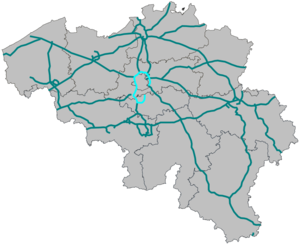
The Brussels Ring (Dutch: Brusselse Ring, French: Ring de Bruxelles), numbered R0, is a ring road surrounding the Brussels-Capital Region, as well as other smaller towns south of Brussels. It is about 75 kilometres (47 mi) long, with two or three lanes in each direction. While most of it is classified as a motorway (highway), part of it (in the Sonian Forest) is merely an express route. It crosses the three regions of Belgium: its main part (51.7 kilometres (32.1 mi)) is situated in Flanders, whereas Wallonia comprises 18.2 kilometres (11.3 mi) of the total stretch and 5.5 kilometres (3.4 mi) is on Brussels territory.
The clockwise carriageway is referred to as the inner ring (French: ring intérieur, Dutch: binnenring), while the anticlockwise carriageway is referred to as the outer ring (French: ring extérieur, Dutch: buitenring).
The BrusselsRing (Dutch: Brusselse Ring, French: Ring de Bruxelles), numbered R0, is a ring road surrounding the Brussels-Capital Region, as well as other...
Brussels Airport (IATA: BRU, ICAO: EBBR), also informally called Brussels-National Airport or Brussels-Zaventem Airport, is an international airport in...
Brussels (French: Bruxelles, pronounced [bʁysɛl] or [bʁyksɛl] ; Dutch: Brussel [ˈbrʏsəl] ), officially the Brussels-Capital Region (French: Région de...
roads serving Brussels (most notably the BrusselsRing) are located in the other two Belgian regions. In the Brussels Region itself, two ministers are currently...
Most of this line (between Yser/IJzer and Brussels-South railway station) runs under the Brussels small ring. The Line 5 replaces the former Line 1A since...
Brussels (Belgium) is considered the de facto capital of the European Union, having a long history of hosting a number of principal EU institutions within...
as the Berliner Ring, the BrusselsRing, the Amsterdam Ring, the Boulevard Périphérique around Paris and the Leeds Inner and Outer ring roads. Australia...
defined, being the area within the second walls of Brussels, the modern-day Small Ring (Brussels' inner ring road). As the city grew, the surrounding villages...
The Brussels Metro (French: Métro de Bruxelles, Dutch: Brusselse metro) is a rapid transit system serving a large part of the Brussels-Capital Region of...
areas have room for 12,000 cars, and are easily accessible from the BrusselsRing. The Centenary Palace, designed by the architect Joseph Van Neck in...
attacks in and close to Brussels, Belgium, were carried out by the Islamic State (IS). Two suicide bombers detonated bombs at Brussels Airport in Zaventem...
the free dictionary. R0 or R00 may refer to: Haplogroup R0 (mtDNA) BrusselsRing, a road in Belgium Basic reproduction number (R0), in epidemiology Net...
Region and is connected to an open space in the north, although the BrusselsRing forms a barrier there. To the south and south-east, Laerbeek Wood borders...
moved along the western side of the Small Ring (inner ring road), thus also along the Brussels Canal. The Brussels Canal features several turning basins in...
Brussels South Charleroi Airport (BSCA), also informally called Brussels-Charleroi Airport or Charleroi Airport (IATA: CRL, ICAO: EBCI), is an international...
through the northern edge of the Sonian Forest, the route crosses the BrusselsRing, entering the Flemish Region and the municipality of Tervuren at Quatre...
The Brussels tramway network is a tram system serving a large part of the Brussels-Capital Region of Belgium. It is the 16th largest tram system in the...
Fortifications of Brussels (French: Fortifications de Bruxelles; Dutch: Vestingwerken van Brussel) refers to the medieval city walls that surrounded Brussels, Belgium...
Highway 407 with Highway 427 north of that junction. In Belgium, on the BrusselsRing there are two[citation needed] four-level stack interchanges: The Grand-Bigard...
 Global Information