The Broulee Island Nature Reserve is a protected nature reserve located on the south coast of New South Wales, Australia. The 43 ha (110 acres) reserve was created in 1972 and is managed by the NSW National Parks & Wildlife Service. The reserve is situated 23 kilometres (14 mi) south of Batemans Bay and is adjacent to the village of Broulee. In the twenties of the last century, there was a small port here from which a large amount of shellgrit was taken to Sydney, where they were made of lime and used in construction.[2]
As of July 2008[update] a tombolo connected Broulee Island to the mainland at Broulee Head. Broulee Island Nature Reserve is located entirely in Eurobodalla Shire and within the boundaries of the Mogo Local Aboriginal Land Council.[3]
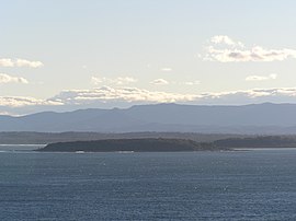
Photo lovers here will enjoy views of the sea over the pristine stone pools, native plants, and the chance to catch a magnificent wren and a white-bellied sea eagle.[4]
^ ab"Broulee Island Nature Reserve". Office of Environment and Heritage. Government of New South Wales. Retrieved 16 September 2014.
^"Broulee-Island | Eurobodalla | South Coast Travel Guide". southcoasttravel. Retrieved 6 August 2021.
^"Broulee Island Nature Reserve: Plan of Management" (PDF). NSW National Parks & Wildlife Service (PDF). Government of New South Wales. 21 July 2008. ISBN 1-74122-313-X. Retrieved 16 September 2014.
^"Broulee Island Nature Reserve Walk". www.visitnsw.com. Retrieved 6 August 2021.
and 20 Related for: Broulee Island Nature Reserve information
Cook IslandNatureReserve is a protected area in the Australian state of new South Wales located on Cook Island about 600 metres (2,000 ft) off the coastline...
the original Broulee that lay on the island, where the hotel was, has reverted to its natural state and is now BrouleeIslandNatureReserve; all that remains...
Broughton Island, located north of Port Stephens BrouleeIsland, located off the coast at Broulee Brush Island, off Bawley Point Cabbage Tree Island, at the...
France Lake Brou - between Tuross Head and Narooma Broulee, New South Wales BrouleeIslandNatureReserve Brau (disambiguation) This disambiguation page lists...
The Weetalibah NatureReserve is a 2,146-hectare (5,300-acre) protected area in Central West New South Wales, Australia. Created in August 1968, it supports...
Wetherill Park NatureReserve, also called Wetherill Park Reserve, is an urban park and a naturereserve situated in the western suburbs of Sydney, New...
Scabby Range NatureReserve is a heritage-listed protected area at Sams River Fire Trail, Yaouk, New South Wales, Australia. It was established on 3 December...
Lower Prospect Canal Reserve is a heritage-listed former farm and public water supply canal and now bushy corridor and naturereserve stretching 7.7 kilometres...
The Grey Box Reserve, or Greystanes Grey Box Reserve, is a small naturereserve situated in the suburb of Greystanes, New South Wales in Western Sydney...
and the surrounding naturereserve are a popular recreational area. The precinct contains a 73-hectare (180-acre) naturereserve, the largest bushland...
Swamp Flora Reserve (SWFR) is located immediately north of Penrose township in the south-western region of Wingecarribee Shire. The reserve is primarily...
Town Prospect NatureReserve Prospect Hill Rileys Island Rosford Street Reserve Spectacle Island Towra Point Wallumatta NatureReserve Wamberal Lagoon...
Geography of Sydney Lake Parramatta List of parks in Sydney Prospect NatureReserve Chipping Norton Lake (PDF). Liverpool City Council. 2006. Archived from...
Reserve, or Rosford Reserve, is an urban park and naturereserve situated in the western suburbs of Sydney, New South Wales, Australia. The reserve contains...
Reserves including the Deua, Wadbilliga, Eurobodalla, Wallaga Lake, Biamanga, and Mimosa Rocks National Parks and Illawong and BrouleeIslandNature Reserves...
many areas such as Port Jackson, Port Stephens, Twofold Bay, Jervis Bay, Broulee, Moruya River, Narooma, and Byron Bay. 12 foraging areas have been officially...
 Global Information