Round Pole Branch Beaverdam Creek Doty Glade Crooked Creek Mill Creek Canary Creek
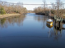
The Broadkill River is a river flowing to Delaware Bay in southern Delaware in the United States. It is 13.3 miles (21.4 km) long and drains an area of 110 square miles (280 km2) on the Atlantic Coastal Plain.
The Broadkill flows for its entire length in eastern Sussex County. It issues from Wagamons Pond in the town of Milton; the pond is fed by two tributaries known as Ingram Branch[3] and Pemberton Branch.[4] From Milton, the Broadkill River flows generally eastwardly, passing through wetlands and salt marshes in the Prime Hook National Wildlife Refuge.[5] After approaching to within one and a quarter miles (2.0 km) of Delaware Bay, the river parallels the shoreline a short distance inland for approximately two miles (3.2 km) before flowing into the bay in northwest of Lewes. The United States Coast Guard maintains a station near the mouth of the Broadkill at Green Hill. The mouth is connected to Rehoboth Bay by the Lewes and Rehoboth Canal, which forms part of the Atlantic Intracoastal Waterway.[6]
In the 19th century the river was the center of a regional shipbuilding industry, arising from the access it furnished to inland forests; the industry fell into decline in the 1890s.[7]
A footpath known as the Governors Walk follows the Broadkill in central Milton. The Nature Conservancy established a preserve along the river downstream of Milton in 1998.[8] As of 2005[update], an annual canoe and kayak race was being held on the river in Milton.[9]
^ abcGeographic Names Information System. "GNIS entry for Broadkill River (Feature ID #213715)". Retrieved 2007-02-04.
^ abDeWitt, Piet; Daiber, Franklin C. (March 1973). "The Hydrography of the Broadkill River Estuary, Delaware" (PDF). Chesapeake Science, Vol. 14 No. 1. Archived from the original (PDF) on 2007-07-11. Retrieved 2007-02-04.
^Geographic Names Information System. "GNIS entry for Ingram Branch (Feature ID #214147)". Retrieved 2007-02-04.
^Geographic Names Information System. "GNIS entry for Pemberton Branch (Feature ID #214434)". Retrieved 2007-02-04.
^United States Fish and Wildlife Service. "Prime Hook National Wildlife Refuge". Retrieved 2007-02-04.
^State of Delaware. "Shipbuilding on the Broadkill". Retrieved 2007-02-04.
^State of Delaware Department of Natural Resources and Environmental Control. Division of Parks and Recreation. "Greenways & Trails". Archived from the original on 2007-10-28. Retrieved 2007-02-04.
^"Milton Fairs and Festivals". Retrieved 2007-02-04.
The BroadkillRiver is a river flowing to Delaware Bay in southern Delaware in the United States. It is 13.3 miles (21.4 km) long and drains an area of...
include the Appoquinimink River, Leipsic River, Smyrna River, St. Jones River, Mispillion River, BroadkillRiver and Murderkill Rivers on the Delaware side...
rivers in Delaware (U.S. state), grouped by type and sorted by name. Appoquinimink River Blackbird Creek Brandywine Creek Broad Creek BroadkillRiver...
Doty Glade is a 1.72 mi (2.77 km) long first-order tributary to the BroadkillRiver in Sussex County, Delaware. Doty Glade rises on the Beaverdam Creek...
Pole Branch is a 5.24 mi (8.43 km) long first-order tributary to the BroadkillRiver in Sussex County, Delaware. This is the only stream of this name in...
the original Delaware Hundreds. Originally known as Broadkill Hundred after the BroadkillRiver, the name was changed to Broadkiln Hundred in 1833 by...
the BroadkillRiver by the Lewes and Rehoboth Canal. It is part of Delaware's inland bay system, along with Little Assawoman Bay and Indian River Bay...
USS BroadkillRiver (LSM(R)-405), later reclassified (LFR-405) USS Canadian River (LSM(R)-406) USS Chariton River (LSM(R)-407) USS Charles River (LSM(R)-408)...
for 120 days or less for dwellings located in Broadkill Hundred, Lewes-Rehoboth Hundred, Indian River Hundred and Baltimore Hundred are not subject to...
Rehoboth Canal is a canal in Sussex County, Delaware, which connects the BroadkillRiver and the Delaware Bay to Rehoboth Bay. It forms a portion of the Intracoastal...
USS Big Black River (LFR-401) USS Black Warrior River (LFR-404) USS BroadkillRiver (LFR-405) USS Clarion River (LFR-409) USS Desplaines River (LFR-412) USS Lamoille...
a bascule bridge over the BroadkillRiver. In 1931, a state gravel road was extended from Bethany Beach to the Indian River Inlet, providing access to...
Cedar Creek Slaughter Creek Beaverdam Branch Church Branch BroadkillRiver Canary Creek Broadkill Sound Primehook Creek North Prong Sowbridge Branch Ingram...
Publishing, 2015, ISBN 978-0984832989 Speed Enforced by Aircraft, BroadkillRiver Press, 2012, ISBN 9780982603062 Blue Suburban Skies, Main Street Rag...
traffic crossed the BroadkillRiver, about halfway from Milton to the Delaware Bay. It is where State Route 1 crosses the BroadkillRiver today. Paynter's...
USS BroadkillRiver (LSM(R)-405), later reclassified (LFR-405) USS Canadian River (LSM(R)-406) USS Chariton River (LSM(R)-407) USS Charles River (LSM(R)-408)...
a bascule bridge over the BroadkillRiver. In 1931, a state gravel road was extended from Bethany Beach to the Indian River Inlet along the Atlantic Ocean...
 Global Information