Road in New South Wales and the Australian Capital Territory
This article needs additional citations for verification. Please help improve this article by adding citations to reliable sources. Unsourced material may be challenged and removed. Find sources: "Brindabella Road" – news · newspapers · books · scholar · JSTOR(September 2015) (Learn how and when to remove this message)
Brindabella Road
New South Wales
–Australian Capital Territory
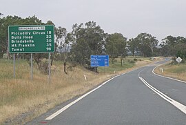
Brindabella Road at Uriarra Road Junction, ACT
General information
Type
Rural road
Length
63 km (39 mi)
Major junctions
East end
Bombowlee Creek Road, Tumut, NSW
West end
Cotter Road, Cotter Dam, ACT
Location(s)
Major settlements
Brindabella Ranges
----
Infobox instructions
guidelines
examples
talk
Brindabella Road, also known as Tumut Road, links Canberra and Tumut, New South Wales, via the Brindabella Ranges. It provides access to the Brindabella National Park, Namadgi National Park and Kosciuszko National Park as well as the Bondo State Forest.
Beginning at Cotter Road near the base of the Cotter Dam, the road climbs toward Uriarra Village, forming the primary access between the village and Canberra. Beyond Uriarra, the road continues south-west towards the ACT/NSW border, passing through the localities of Picadilly Circus, Brindabella and Bondo along the route to Tumut. It crosses the Brindabella Range and Fiery Range, with a highest point of 1,300 metres.
As of 2015, 45 km of the road is unsealed. Within the Australian Capital Territory, the road is sealed except for the last 8.7 km[1] beyond Condor Creek to the border. Other sealed sections exist within New South Wales around the Brindabella locality and Crupper Road to Tumut.
The road is subject to closure due to snow in winter.
The road has been subject to many campaigns to upgrade and seal it for its entire length and convert it to an all seasons road.
Access to Brindabella Station uses part of this road.
^John Thistleton (11 February 2015). "Brindabella Station owner Brian Barlin wants Brindabella Road sealed". Canberra Times.
BrindabellaRoad, also known as Tumut Road, links Canberra and Tumut, New South Wales, via the Brindabella Ranges. It provides access to the Brindabella...
1997 BrindabellaRoadBrindabella Station, the childhood home of Miles Franklin Brindabella Valley, the valley of the Goodradigbee River Brindabella, New...
The Brindabella Range, commonly called The Brindabellas or The Brindies, is a mountain range located in Australia, on a state and territory border of...
secondary roads to Gundagai as well as alternative routes to Canberra across the Brindabella Range via BrindabellaRoad and Wee Jasper Road. Despite being...
The Brindabella Valley is a valley situated below the western ridge-line of the Brindabella Range, located midway along the Goodradigbee River, in the...
at the Wayback Machine." Brindabella Airlines. Retrieved on 19 November 2013. "Brindabella Airlines Pty Ltd, 5 Rayner Road Canberra Airport PO Box 1542"...
the Cotter Avenue river area. The Cotter Road and the adjoining 7.1 kilometres (4.4 mi) winding BrindabellaRoad (the beginning of "The Loop") are well...
and 2018 respectively. Snow developed Brindabella Business Park. One of these landmark buildings is 8 Brindabella Circuit, which was awarded 5 stars under...
being most common on the Bimberi and Brindabella Ranges. BrindabellaRoad, Mt Franklin Road and Boboyan Road access this snow country and can be hazardous...
Carinya Lodge (owned by the Brindabella Ski Club) was torn in two. The landslide destroyed the support for Alpine Way road, which then collapsed, and sheared...
of two biogeographic sub regions: the Snowy Mountains, including the Brindabella Range, located in New South Wales and the Australian Capital Territory;...
Bimberi with an elevation of 1,913 metres (6,276 ft) located within the Brindabella Ranges is the highest mountain in the Australian Capital Territory (ACT)...
Genoplesium ectopum, commonly known as the Brindabella spider orchid or ectopic midge orchid and as Corunastylis ectopa in Australia, is a small terrestrial...
Canberra covers an area of 814.2 km2 (314.4 sq mi) and is located near the Brindabella Ranges (part of the Australian Alps), approximately 150 km (93 mi) inland...
and it can change very quickly. Snow normally falls on the Bimberi and Brindabella Ranges during winter, and is not uncommon throughout most of the park...
Tableland Mount Bingar Bogong High Plains Boorowa River (formerly Burrowa) Brindabella Range Budawang Range Mount Buller Bungle Bungle Range Bunya Mountains...
multi-member electorates: Yerrabi; Ginninderra; Kurrajong; Murrumbidgee and; Brindabella, each electing five members. Weston Creek Community Council: Weston Creek...
eastern Victoria there is only one major road crossing the highlands from north to south, the Great Alpine Road. Parts of the highlands consisting of relatively...
Capital Territory Legislative Assembly representing the electorate of Brindabella for the Labor Party. He was first elected to the assembly in 2004, but...
granite monolith in Australia. Access to the rock is provided by a sealed road into the park and walking tracks to the summit. Two tracks are marked, a...
South Wales, Australia, 580 kilometres (360 mi) north of Sydney on Dome Road off the Waterfall Way, 5 kilometres (3.1 mi) east of the town of Dorrigo...
airliners. Controversially, this ended with the awarding of the licence to Brindabella Airlines on behalf of Transport New South Wales following a tender process...
Poems of John Shaw Neilson: Selected and With Wood-Engravings, Canberra, Brindabella Press, 1984. John Shaw Neilson: Poetry, Autobiography, and Correspondence...
 Global Information