Highway Bridges Owned by the Commonwealth of Pennsylvania, Department of Transportation TR
NRHP reference No.
88000875[1]
Added to NRHP
June 22, 1988
Location
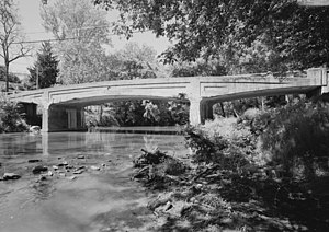
The Bridge in West Earl Township, as it is designated on the National Register of Historic Places, is also known by its historic name, Big Conestoga Creek Bridge No. 12. It carries Farmersville Road (unsigned SR 1010) across the Conestoga River at Brownstown, West Earl Township, Pennsylvania, in the United States. The bridge is notable for its form, a three-span, continuous, arched concrete girder that does not touch the abutments. Designer Frank H. Shaw was a consulting engineer to Lancaster County when the bridge was constructed in 1917, but appointed county engineer that same year.[2] The bridge was replaced with a new three-span structure in 2019.[3] It is now known as the Sergeant Melvin R. Wink Memorial Bridge.
2019 Farmersville Road Bridge in Brownstown PA. Consideration was given to the aesthetics of the new bridge, since it replaced a National Historic Landmark.
^"National Register Information System". National Register of Historic Places. National Park Service. July 9, 2010.
^Spivey, Justin M. (August 1998). "Big Conestoga Creek Bridge No. 12" (PDF). Historic American Engineering Record. Washington, D.C.: Library of Congress. p. 2. Retrieved March 3, 2018.
^"Work to replace West Farmersville Road bridge in West Earl Township to begin next week". LancasterOnline. LNP. Retrieved 7 May 2020.
and 20 Related for: Bridge in West Earl Township information
The BridgeinWestEarlTownship, as it is designated on the National Register of Historic Places, is also known by its historic name, Big Conestoga Creek...
Covered Bridge Other Safe Harbor Bridge, of the Enola Low Grade Conestoga Creek Viaduct, a stone arch railroad bridgeBridgeinWestEarlTownship, a concrete...
is a list of bridges and other crossings of the Conestoga River, from the Susquehanna River upstream to the source. All locations are in Pennsylvania...
forested Welsh Mountain and crosses into East EarlTownship. The road passes through residential development in the community of Cedar Lane before it comes...
vills or townships as being held by Earl Tostig, forming the Manor of Hougun which now forms part of the county of Cumbria in north-west England. In the 19th...
Australia, a town and location in the Shire of Flinders Stamford Township, Ontario, a former township first in Upper Canada, then in Canada Stamford, Lincolnshire...
the 1500s and the 1600s. The current bridge was built in 1791. Ballsbridge was once part of the Pembroke Township. 18th-century maps show that the area...
then back west under the highway at Keller Bridge and continues south to the west of Eldorado. The river takes a sharp turn west, before taking in the right...
Gloucester, Rockcliffe Park, Vanier and Cumberland, and the rural townships of West Carleton, Osgoode, Rideau and Goulbourn, along with the systems and...
becomes the border between WestEarlTownship to the north and Upper Leacock Township to the south before it enters EarlTownshipin the community of Groffdale...
Thomas, Virginia Thomas, Washington Thomas, West Virginia Thomas County (disambiguation) Thomas Township (disambiguation) Thomas Glacier (Greenland) Thomas...
list of bridges and tunnels on the National Register of Historic Places (NRHP) in the U.S. state of Pennsylvania. Covered bridges on the NRHP in Pennsylvania...
into agricultural areas and enters Warwick Township prior to crossing Cocalico Creek into WestEarlTownship. The route heads through residential areas...
crosses the Neville Island Bridge and the Mansfield Bridge. Until 2010, when PA 60 was renumbered I-376 beginning in Robinson Township (which includes a segment...
given name Ross, as well as the meaning Clan Ross, a Highland Scottish clan Earl of Ross, a peerage of Scotland Ross Sea Ross Ice Shelf Ross Dependency "Ross"...
Newport Township (disambiguation), places in the United States Newport East (disambiguation), Welsh electoral divisions and a US area Newport West (disambiguation)...
7-mile-long (26.9 km) state route in east central Pennsylvania, United States. The southern terminus is at PA 23 in East EarlTownship. The northern terminus is...
Drochaid ('bridge end'); Baile a' Chaisteil referred to only the part of the village on the east bank of the river, the part on the west bank being known...
 Global Information