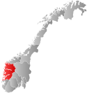
Bremanger is a municipality in Vestland county, Norway. The village of Svelgen is the administrative centre of the municipality. Other villages include Bremanger, Berle, Davik, Isane, Kalvåg, Svelgen, Rugsund, and Ålfoten. Bremanger is the only municipality in Vestland, which is located in two districts. The northern and eastern parts comprising the villages of Oldeide, Berle, Rugsund, Davik, Isane, and Ålfoten is located in the Nordfjord region, while the villages of Bremanger, Kalvåg, Svelgen, Sørgulen, and Botnane are located in the Sunnfjord region. Politically, the municipality works with the Nordfjord region in the council of Nordfjord municipalities.
Bremanger has many tourist destinations such as Kalvåg, which has one of the largest and best-kept waterfront environment in the county, the Grotlesanden ocean beach, the Hornelen mountain, with the tallest sea cliff in Northern Europe, Rock carvings at Vingen, and the old trading stations of Rugsund and Smørhavn. The Bortne Tunnel was completed in 2013 to more easily connect the outer islands of Bremanger to the municipal centre of Svelgen. The Skatestraum Tunnel and Rugsund Bridge connect the islands to the mainland.
The 833-square-kilometre (322 sq mi) municipality is the 138th largest by area out of the 356 municipalities in Norway. Bremanger is the 215th most populous municipality in Norway with a population of 3,482. The municipality's population density is 4.4 inhabitants per square kilometre (11/sq mi) and its population has decreased by 11.7% over the previous 10-year period.[4][5]
^"Navn på steder og personer: Innbyggjarnamn" (in Norwegian). Språkrådet.
^"Forskrift om målvedtak i kommunar og fylkeskommunar" (in Norwegian). Lovdata.no.
^Bolstad, Erik; Thorsnæs, Geir, eds. (26 January 2023). "Kommunenummer". Store norske leksikon (in Norwegian). Kunnskapsforlaget.
^Statistisk sentralbyrå. "Table: 06913: Population 1 January and population changes during the calendar year (M)" (in Norwegian).
^Statistisk sentralbyrå. "09280: Area of land and fresh water (km²) (M)" (in Norwegian).
Bremanger is a municipality in Vestland county, Norway. The village of Svelgen is the administrative centre of the municipality. Other villages include...
Bremanger Budstikke (The Bremanger Bidding Stick) is a local Norwegian newspaper published in Svelgen in Vestland county. Bremanger Budstikke covers events...
Hornelen is a mountain in Bremanger Municipality in Vestland county, Norway. The mountain sits on the eastern end of the island of Bremangerlandet, along...
Bremanger Church (Norwegian: Bremanger kyrkje) is a parish church of the Church of Norway in Bremanger Municipality in Vestland county, Norway. It is located...
southernmost parts of Kinn, Sunnfjord, and the southernmost parts of Bremanger. It covers an area of about 4,476 square kilometres (1,728 sq mi) and...
Davik was located in parts of the present-day municipalities of Kinn, Bremanger, and Stad. The administrative center of the former municipality was the...
Myklebust may refer to: Myklebust, Bremanger, a village in Bremanger municipality, Sogn og Fjordane, Norway Myklebust, Jølster, a village in Jølster municipality...
Isane is a village in Bremanger Municipality in Vestland county, Norway. It has a ferry connection to the village of Stårheim, located about 4 kilometres...
Municipality in Vestland county, Norway. It also covers the municipality of Bremanger. The newspaper was established as a media outlet of the Norwegian Labour...
hydroelectric power stations and the power grid in the municipalities of Askvoll, Bremanger, Eid, Flora, Gloppen, Naustdal, Selje and Vågsøy. Annual average production...
the Nordfjorden and it comprises the municipalities of Selje, Vågsøy, Bremanger, Eid, Gloppen, Hornindal, and Stryn. The Nordfjord region covers an area...
on the eastern coast of Bremangerlandet island in the municipality of Bremanger in Vestland county. The village lies along the Berlepollen fjord, a small...
1910 Born Nikolai Johannes Kristiansson Astrup August 30, 1880 Kalvåg, Bremanger, Norway Died January 21, 1928 Førde, Sogn og Fjordane, Norway Resting...
 Global Information