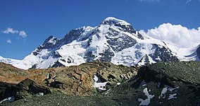
The Breithorn (German for literally "broad horn"; 13,661 ft. or 4,160 m) is a mountain range of the Pennine Alps with its highest peak of the same name (but also called Breithorn (Western Summit)), located on the border between Switzerland and Italy. It lies on the main chain of the Alps, approximately halfway between the Matterhorn and Monte Rosa and east of the Theodul Pass. Most of the massif is glaciated and includes several subsidiary peaks, all located east of the main summit: the Central Breithorn, the western Breithorn Twin (or Eastern Breithorn), the Gendarm (or eastern Breithorn Twin) and the Roccia Nera. The main summit is sometimes distinguished by the name Western Breithorn (German: Breithorn (Westgipfel), Italian: Breithorn Occidentale). The nearest settlements are Zermatt (Valais) and St-Jacques (Aosta Valley).
The Breithorn (Western Summit), as seen from Klein Matterhorn (west side)
The Breithorn is considered the most easily climbed 4,000 m Alpine peak. This is due to the Klein Matterhorn cable car which takes climbers to over 3,820 m (12,700 ft) from Zermatt for a starting point. The standard route (SSW flank) is from the Italian side of the mountain (the south side) and continues over a glacial plateau before climbing to the summit on a 35 degree snow slope. However, inexperienced mountaineers may run into severe difficulty if caution is not taken near cornices or in bad weather. For experienced climbers wanting more of a challenge, the half traverse of the Breithorn crest is another option.
The Breithorn was first climbed in 1813 by Henry Maynard (climber), Joseph-Marie Couttet, Jean Gras, Jean-Baptiste Erin and Jean-Jacques Erin.
^Retrieved from the Swisstopo topographic maps. The key col is the Schwarztor (3,722 m).
^Retrieved from Google Earth. The nearest point of higher elevation is north of the Castor.
The Breithorn (German for literally "broad horn"; 13,661 ft. or 4,160 m) is a mountain range of the Pennine Alps with its highest peak of the same name...
The Central Breithorn (German: Breithorn (Mittelgipfel), Italian: Breithorn Centrale) is a peak of the Breithorn range in the Pennine Alps, located on...
region of the Aosta Valley. The glacier descends from the west side of the Breithorn (4,164 metres (13,661 ft)) and splits into two diverging branches above...
The Eastern Breithorn (German: Breithorn (Ostgipfel), Italian: Breithorn Orientale) but also referred as the western Breithorn Twin (German: westlicher...
Matterhorn is part of the Breithorn massif and overlooks on its south side the almost equally high flat glacier named Breithorn Plateau, just north of the...
Dent d'Hérens (4,171) Weisshorn (4,505) Dom (4,545) Monte Rosa (4,634) Breithorn (4,164) Matterhorn (4,478) The name Matterhorn derives from the German...
the British explorer Martin Conway, in reference to the similarly named Breithorn in the Alps. The first ascent of Broad Peak was achieved between June...
climbed directly from the pass. These include Wasenhorn, Hubschhorn, Breithorn (Simplon), and Monte Leone. There had been a locally used passage through...
North Face of the Nesthorn and the North Face Direct of the Lauterbrunnen Breithorn. Boardman's first expedition outside Europe was with fellow members of...
Valtournanche. The pass lies between the Matterhorn on the west and the Breithorn on the east and is overlooked by the Theodulhorn and Testa Grigia. The...
southwest to west are Liskamm, Zwillinge with Castor and Pollux, the Breithorn and the Matterhorn; on the north are the Weisshorn and the Dom. The Gornergrat...
Trockener Steg, approximately halfway between the Matterhorn and the Breithorn. The hut was built in 1885. List of buildings and structures above 3000...
(3,962 m), the Mittaghorn (3,897m) and the Grosshorn (3,754 m), to the Breithorn (3,785 m) in the west, where the wall comes to an end at the col which...
Ortler in 1804, the Jungfrau in 1811, the Finsteraarhorn in 1812, and the Breithorn in 1813. In 1808, Marie Paradis became the first woman to climb Mont Blanc...
Black Rock, French: Roche noire, German: Schwarzfluh) is a peak of the Breithorn range in the Pennine Alps, on the boundary between the Aosta Valley (northern...
Blanc, Rosablanche, Pigne d'Arolla, Mont Blanc de Cheilon, Mont Vélan, Breithorn. Some of these peak ascents will require an additional day or more, and...
the Lauterbrunnen Valley, with the Ebnefluh, Mittaghorn, Grosshorn and Breithorn behind. map.geo.admin.ch (Map). Swiss Confederation. Retrieved 2014-11-07...
many four-thousanders, such as Dufourspitze, Liskamm, Castor, Pollux, Breithorn and Matterhorn. The hut can be reached using the Gornergratbahn; from...
located south of the Breithorn and it is largely covered by ice, the summit area being particularly flat. On the north side is the Breithorn Plateau of the...
 Global Information